METAR & TAF 30M
30M does not publish a METAR.
Showing the nearest reporting station: KUTA (TUNICA MUNI) · 2.1 NM away. Conditions at 30M may differ.
METAR · KUTA
Observed 13:35Z
KUTA 271335Z AUTO 12006KT 10SM SCT070 29/28 A2997 RMK AO2 T02880278 $
- Wind
- 120° @ 6 kt
- Visibility
- 10 SM
- Temp / Dew
- 29°C / 28°C
- Altimeter
- 29.97 inHg
- Clouds
- SCT
- Density alt
- 1,860 ft
- Ceiling
- Unlimited
- Rules
- VFR
Airport info & contacts
Manager on record, flight service, ARTCC, attendance schedule and pattern altitude — published by the FAA and refreshed every 28 days.
Location
- From city
- 2 NM S
- VFR sectional
- MEMPHIS
- ARTCC
- ZME · MEMPHIS
- NOTAM facility
- GWO (NOTAM-D)
Airport manager
- Name
- KEVIN JONES
- Phone
- 662-363-1461
- Address
- PO BOX 2310, TUNICA MS 38676
Flight service · Hours
- FSS GWO
- GREENWOOD1-800-WX-BRIEF
- Attendance
- MAR-OCT · DALGT
- NOV-FEB · M-F · IREG
Frequencies
Tap any row to copy the frequency to your clipboard.
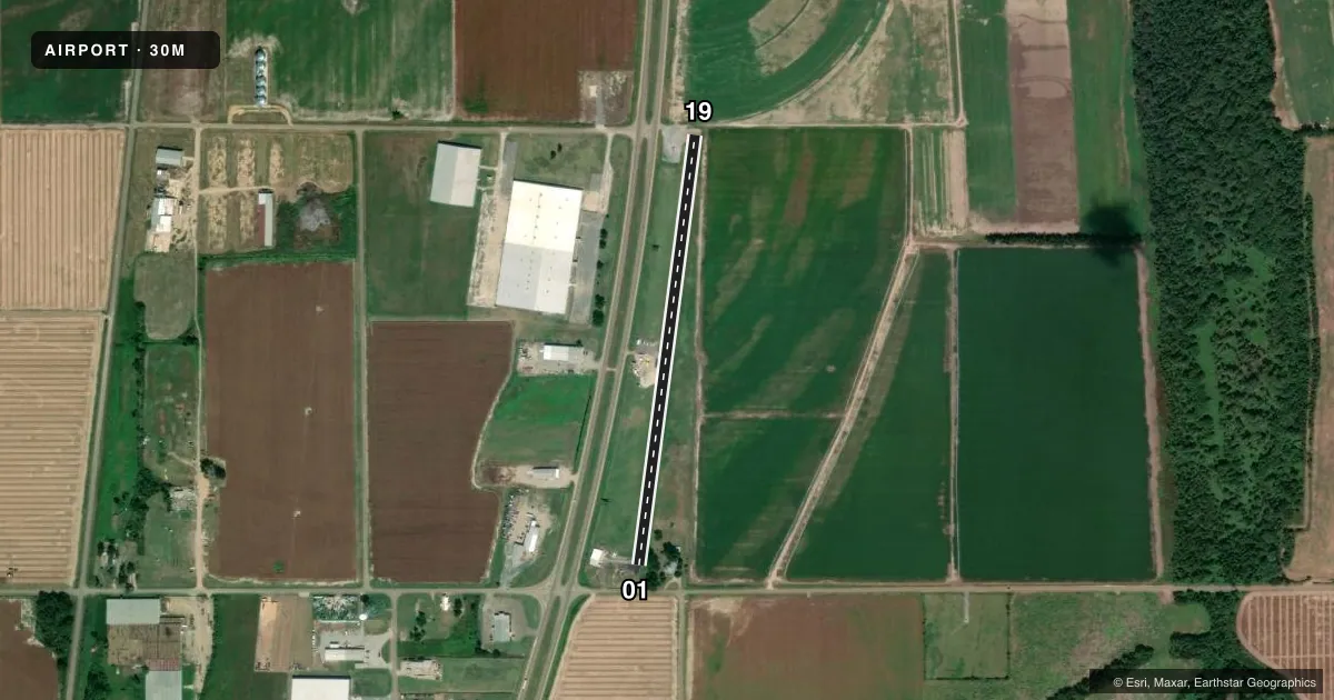
Runways & pattern
Full pagePattern entry · RWY 19
LEFT TRAFFICAirport sketch
Runways drawn to scale from FAA survey coordinates, rendered over satellite imagery. Not for navigation.
Approaches & charts
Services on the field
Fuel grades, oxygen, maintenance, ramp storage and lighting — as declared to the FAA by the airport operator.
Fuel & services
- Fuel
- Not available
- Other services
- AGRI
Ramp & ground
- Transient storage
- Tie-down
- Hangar
- Landing fee
- No fee published
- Wind indicator
- Yes
- Segmented circle
- No
Fuel & FBOs
Cheapest 100LL and Jet A on the field and nearby. Always confirm with the FBO before taxi.
Airport notes
Surface conditions, obstructions, local procedures, lighting outages and other notes published with each FAA cycle.
General notes
- RWY 01/19 80 FT TREES E SIDE S OF RWY VIOLATE 7:1 TRSN SLP.
- FOR CD CTC MEMPHIS APCH AT 901-842-8457.
Runway surface & condition
- 01/19RWY 1 IS 14 FT WID BY 1800 FT LONG; RWY 19 IS 18 FT WID BY 708 FT LONG.
Approach & departure obstructions
- 01ROAD 140 FT FM THR.
Other notes
- EXISTED PRIOR TO 1959.
- CALL AHD TO RES.
- 3CALL MGR.
- MANAGERAFT HRS CALL 662-292-7541.
VFR map & nearby airports
VFR sectional. Tap any ICAO chip to open that airport.
Key facts · 30M
Answer card- ICAO
- 30M
- Name
- RALPH M SHARPE
- Location
- TUNICA, MISSISSIPPI
- Elevation
- 195 ft MSL
- Traffic pattern altitude
- 1,195 ft MSL (1,000 AGL)
- Control tower
- Non-towered (use CTAF)
- Total runways
- 1
- Longest runway
- 01/19 · 2,508 ft
- Published ILS approaches
- 0
- Published frequencies
- 2
- Magnetic variation
- 3°
- Current flight rules
- VFR
- Current wind
- 120° at 6 kt
- Favored runway now
- RWY 19
Ralph M Sharpe Airport is in Tunica, Mississippi. Field elevation is 195 ft MSL. It has one runway, 01/19, which is 2,508 ft long and asphalt. There is no control tower. CTAF and UNICOM are both 122.8. No ILS approaches are published here.
Pattern altitude is not published. Use the standard 1,000 ft AGL pattern for light piston aircraft unless the current Chart Supplement says otherwise. The runway setup is short. Published remarks also call out trees on the east side south of the runway that break the 7 to 1 transition slope. There is also a road 140 ft from the threshold of runway 01. That makes a close look at the runway environment a good idea before arrival.
No on-field FBOs are listed. Call ahead to reserve. Call the manager if you need current field details. After hours, the published manager number is 662-292-7541. For clearance delivery, contact Memphis Approach at 901-842-8457. If you are planning a first visit, check the current Chart Supplement for any operational changes before you go. The airport is non-towered, so expect self-announced traffic on 122.8 and plan your arrival with the short runway and nearby obstructions in mind.