METAR & TAF MS9
MS9 does not publish a METAR.
Showing the nearest reporting station: KOLV (OLIVE BRANCH/TAYLOR FLD) · 12.6 NM away. Conditions at MS9 may differ.
METAR · KOLV
Observed 06:15Z
KOLV 270615Z AUTO 19004KT 10SM 27/27 A2992 RMK A01
- Wind
- 190° @ 4 kt
- Visibility
- 10 SM
- Temp / Dew
- 27°C / 27°C
- Altimeter
- 29.92 inHg
- Clouds
- Clear
- Density alt
- 1,765 ft
- Ceiling
- Unlimited
- Rules
- VFR
Airport info & contacts
Manager on record, flight service, ARTCC, attendance schedule and pattern altitude — published by the FAA and refreshed every 28 days.
Location
- From city
- 5 NM SE
- VFR sectional
- MEMPHIS
- ARTCC
- ZME · MEMPHIS
- NOTAM facility
- GWO (NOTAM-D)
Airport manager
- Name
- TOM FERGUSON
- Phone
- 901-438-5127
- Address
- 4332 MALONE RD, HERNANDO MS 38632
Flight service · Hours
- FSS GWO
- GREENWOOD1-800-WX-BRIEF
- Attendance
- Unattended
Frequencies
Tap any row to copy the frequency to your clipboard.
Runways & pattern
Full pagePattern entry · RWY 10
RIGHT TRAFFICRunway end performance
| End | TORA | TODA | ASDA | LDA | VGSI | Approach lights | Obstruction |
|---|---|---|---|---|---|---|---|
| 10 | — | — | — | — | — | — | 49', trees, 550' from thr, slope 7 |
| 28 | — | — | — | — | — | — | 25', trees, 700' from thr, slope 20 |
Declared distances in feet. TORA = takeoff run available, TODA = takeoff distance, ASDA = accelerate-stop, LDA = landing distance.
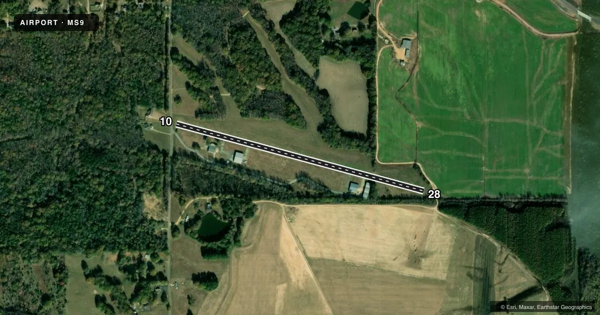
Airport sketch
Runways drawn to scale from FAA survey coordinates, rendered over satellite imagery. Not for navigation.
Approaches & charts
Services on the field
Fuel grades, oxygen, maintenance, ramp storage and lighting — as declared to the FAA by the airport operator.
Fuel & services
- Fuel
- 100
Ramp & ground
- Transient storage
- Hangar
- Segmented circle
- No
Fuel & FBOs
Cheapest 100LL and Jet A on the field and nearby. Always confirm with the FBO before taxi.
Airport notes
Surface conditions, obstructions, local procedures, lighting outages and other notes published with each FAA cycle.
General notes
- FUEL AVBL 24 HRS WITH CREDIT CARD, FOR SVC CALL 901-387-9890.
- MIGRATORY WATERFOWL AREA 0.2 NM SE OF ARPT.
- RCMD ALL ACFT LAND RWY 28, TKOF RWY 10.
- FOR CD CTC MEMPHIS ARTCC AT 901-368-8453/8449.
Approach & departure obstructions
- 10TWR 0.7 NM N 311 FT AGL. DTHR 922 FT, 2738 FT RMNG.
- 10MARKINGS BADLY FADED.
- 28MARKINGS BADLY FADED.
- 10SLP 30:1 TO DTHR.
Other notes
- CALL AHD TO RES.
VFR map & nearby airports
VFR sectional. Tap any ICAO chip to open that airport.
Key facts · MS9
Answer card- ICAO
- MS9
- Name
- EAGLES RIDGE
- Location
- HERNANDO, MISSISSIPPI
- Elevation
- 262 ft MSL
- Traffic pattern altitude
- 1,262 ft MSL (1,000 AGL)
- Control tower
- Non-towered (use CTAF)
- Total runways
- 1
- Longest runway
- 10/28 · 3,300 ft
- Published ILS approaches
- 0
- Published frequencies
- 1
- Magnetic variation
- 2°
- Current flight rules
- VFR
- Current wind
- 190° at 4 kt
- Favored runway now
- RWY 10
Eagles Ridge (MS9) sits in Hernando, Mississippi. Field elevation is 262 ft MSL. The airport has one runway, 10/28, which is 3,300 ft long and paved concrete. There is no control tower. CTAF is 122.9. No ILS approaches are published here.
Pattern altitude is not published. Use the standard 1,000 ft AGL pattern unless the current Chart Supplement says otherwise. The published remarks matter here. Runway 10 has a displaced threshold of 922 ft, with 2,738 ft remaining. There is also a 30 to 1 slope to that displaced threshold. Markings on both runway ends are reported as badly faded. The published recommendation is to land runway 28 and take off runway 10.
Fuel is available 24 hours with credit card. Call ahead to reserve. For service, call 901-387-9890. There are no on-field FBOs listed in the facts, so verify current support before you go. For clearance delivery, Memphis ARTCC is listed at 901-368-8453 or 901-368-8449. A migratory waterfowl area lies 0.2 NM southeast of the airport, so expect bird activity in the area.