METAR & TAF KPMU
Current METAR
Observed 03:35Z
KPMU 270335Z AUTO 00000KT 6SM BR CLR 27/26 A2993 RMK AO2
- Wind
- 000° @ 0 kt
- Visibility
- 6 SM
- Temp / Dew
- 27°C / 26°C
- Altimeter
- 29.93 inHg
- Clouds
- CLR
- Density alt
- 1,702 ft
- Ceiling
- Unlimited
- Rules
- VFR
Airport info & contacts
Manager on record, flight service, ARTCC, attendance schedule and pattern altitude — published by the FAA and refreshed every 28 days.
Location
- From city
- 4 NM NE
- VFR sectional
- MEMPHIS
- ARTCC
- ZME · MEMPHIS
- NOTAM facility
- GWO (NOTAM-D)
Airport manager
- Name
- AIRPORT MANAGEMENT SOLUTIONS, LLC
- Phone
- 662-563-4100
- Address
- 2 AIRPORT RD, BATESVILLE MS 38606
Flight service · Hours
- FSS GWO
- GREENWOOD1-800-WX-BRIEF
- Attendance
- MON-FRI · 0700-1700
- SAT-SUN · 0800-1700
Frequencies
Tap any row to copy the frequency to your clipboard.
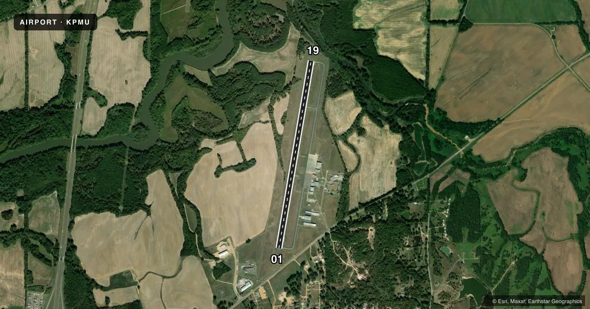
Runways & pattern
Full pagePattern entry · RWY 01
LEFT TRAFFICRunway end performance
| End | TORA | TODA | ASDA | LDA | VGSI | Approach lights | Obstruction |
|---|---|---|---|---|---|---|---|
| 01 | — | — | — | — | PAPI 2-box left(4°) | — | 97', trees, 2300' from thr, 0' R of cntrln, slope 21 |
| 19 | — | — | — | — | PAPI 2-box left(4°) | — | 33', trees, 920' from thr, 100' R of cntrln, slope 21 |
Declared distances in feet. TORA = takeoff run available, TODA = takeoff distance, ASDA = accelerate-stop, LDA = landing distance.
Airport sketch
Runways drawn to scale from FAA survey coordinates, rendered over satellite imagery. Not for navigation.
Approaches & charts
Services on the field
Fuel grades, oxygen, maintenance, ramp storage and lighting — as declared to the FAA by the airport operator.
Fuel & services
- Fuel
- 100LLA
- Oxygen (bottled)
- Not available
- Oxygen (bulk)
- Not available
- Airframe repair
- Major
- Power plant repair
- Major
- Other services
- INSTR
Ramp & ground
- Transient storage
- Tie-down
- Landing fee
- No fee published
- Customs
- Not available
- Lighting schedule
- SEE RMK
- Beacon schedule
- SS-SR
- Beacon
- White / Green (civil land)(WG)
- Wind indicator
- Lighted
- Segmented circle
- Yes
Fuel & FBOs
Cheapest 100LL and Jet A on the field and nearby. Always confirm with the FBO before taxi.
Airport notes
Surface conditions, obstructions, local procedures, lighting outages and other notes published with each FAA cycle.
General notes
- ULTRALIGHT ACT ON & INVOF ARPT.
- FOR CD CTC MEMPHIS ARTCC AT 901-368-8453/8449.
- CREW CAR AVBL; COML CAR RENTAL NEARBY.
Lighting notes
- MIRL RWY 01/19 OPR DUSK TO 2200, AFT 2200 - CTAF. PAPI RWY 01 & 19 OPR CONSLY.
Fuel notes
- 100LLSELF SVC WITH CREDIT CARD 24 HRS; FULL SVC AVBL.
Approach & departure obstructions
- 0129:1 GS TO DTHR.
Other notes
- 662-501-5559.
- 662-501-5559.
- PILOTS MUST PRVD THEIR OWN TIEDOWN ROPES.
VFR map & nearby airports
VFR sectional. Tap any ICAO chip to open that airport.
Key facts · KPMU
Answer card- ICAO
- KPMU
- Name
- PANOLA COUNTY
- Location
- BATESVILLE, MISSISSIPPI
- Elevation
- 221.1 ft MSL
- Traffic pattern altitude
- 1,221.1 ft MSL (1,000 AGL)
- Control tower
- Non-towered (use CTAF)
- Total runways
- 1
- Longest runway
- 01/19 · 5,001 ft
- Published ILS approaches
- 0
- Published frequencies
- 2
- Magnetic variation
- 1°
- Current flight rules
- VFR
- Current wind
- 000° at 0 kt
- Favored runway now
- –
Panola County Airport sits in Batesville, Mississippi. Field elevation is 221.1 ft MSL. The airport has one runway. Runway 01/19 is 5,001 ft long and asphalt. There is no control tower. CTAF and UNICOM are both 122.8. No ILS approaches are published. Pattern altitude is not published, so plan to verify the current traffic pattern in the FAA Chart Supplement before you go. For light piston traffic, the usual default is 1,000 ft AGL unless published otherwise.
Panola County Airport has one on-field FBO. Panola County Airport carries 100LL and Jet A. 100LL is self-serve with credit card 24 hours. Full service is also available. The field remarks also note ultralight activity on and near the airport. That matters for pattern work and taxi vigilance. Medium intensity runway lights on 01/19 operate from dusk to 2200 local. After 2200, use the CTAF. The PAPI on both runway ends operates continuously. There is also a displaced threshold on runway 01 with a published 29 to 1 glide slope note to that threshold. Pilots should bring their own tiedown ropes. Crew car service is available. Commercial car rental is nearby.