METAR & TAF 04M
04M does not publish a METAR.
Showing the nearest reporting station: KUOX (UNIVERSITY-OXFORD) · 28.9 NM away. Conditions at 04M may differ.
METAR · KUOX
Observed 07:55Z
KUOX 270755Z AUTO VRB03KT 10SM CLR 26/24 A2994 RMK AO2
- Wind
- VAR @ 3 kt
- Visibility
- 10 SM
- Temp / Dew
- 26°C / 24°C
- Altimeter
- 29.94 inHg
- Clouds
- CLR
- Density alt
- 1,775 ft
- Ceiling
- Unlimited
- Rules
- VFR
Airport info & contacts
Manager on record, flight service, ARTCC, attendance schedule and pattern altitude — published by the FAA and refreshed every 28 days.
Location
- From city
- 1 NM SW
- VFR sectional
- MEMPHIS
- ARTCC
- ZME · MEMPHIS
- NOTAM facility
- GWO (NOTAM-D)
Airport manager
- Name
- PARKER SCHMITZ
- Phone
- 662-544-3114
- Address
- PO BOX 8, PITTSBORO MS 38951
Flight service · Hours
- FSS GWO
- GREENWOOD1-800-WX-BRIEF
- Attendance
- Unattended
Frequencies
Tap any row to copy the frequency to your clipboard.
Runways & pattern
Full pagePattern entry · RWY 33
LEFT TRAFFICRunway end performance
| End | TORA | TODA | ASDA | LDA | VGSI | Approach lights | Obstruction |
|---|---|---|---|---|---|---|---|
| 15 | — | — | — | — | PAPI 4-box left(3°) | — | 71', trees, 1640' from thr, 0' R of cntrln, slope 20 |
| 33 | — | — | — | — | PAPI 4-box left(3°) | — | 32', trees, 900' from thr, 0' R of cntrln, slope 21 |
Declared distances in feet. TORA = takeoff run available, TODA = takeoff distance, ASDA = accelerate-stop, LDA = landing distance.
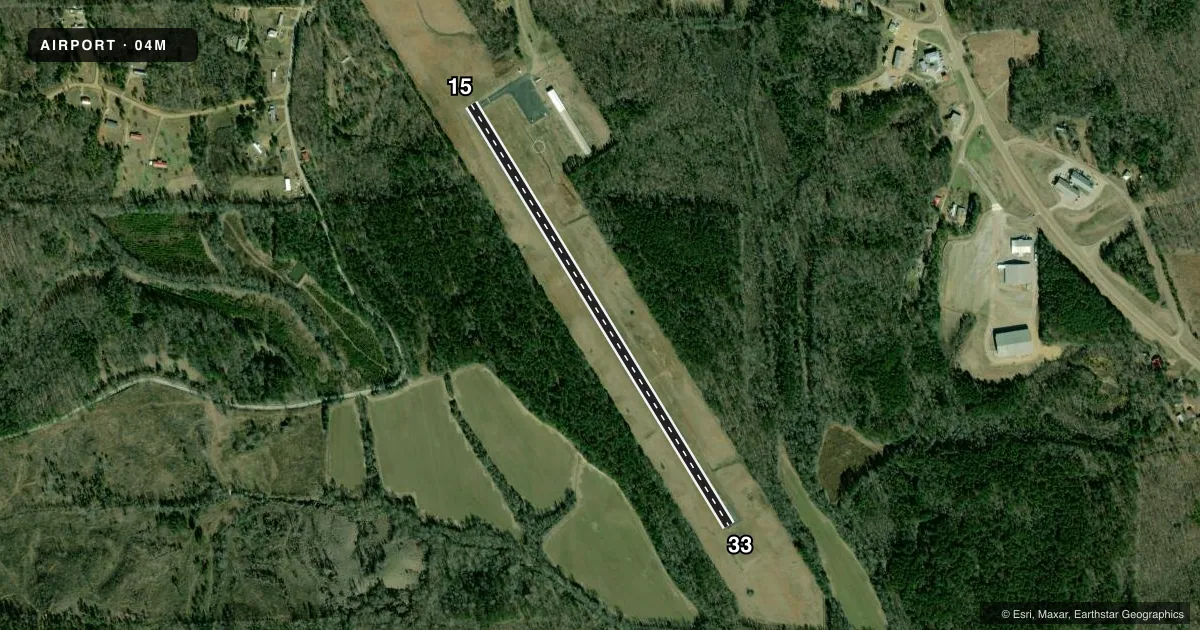
Airport sketch
Runways drawn to scale from FAA survey coordinates, rendered over satellite imagery. Not for navigation.
Approaches & charts
Services on the field
Fuel grades, oxygen, maintenance, ramp storage and lighting — as declared to the FAA by the airport operator.
Fuel & services
- Fuel
- 100LL
- Oxygen (bottled)
- Not available
- Oxygen (bulk)
- Not available
- Airframe repair
- Not available
- Power plant repair
- Not available
- Other services
- AGRI
Ramp & ground
- Transient storage
- Tie-down
- Landing fee
- No fee published
- Customs
- Not available
- Lighting schedule
- SEE RMK
- Beacon schedule
- SS-SR
- Beacon
- White / Green (civil land)(WG)
- Wind indicator
- Lighted
- Segmented circle
- Yes
Fuel & FBOs
Cheapest 100LL and Jet A on the field and nearby. Always confirm with the FBO before taxi.
Airport notes
Surface conditions, obstructions, local procedures, lighting outages and other notes published with each FAA cycle.
General notes
- FOR CD CTC MEMPHIS ARTCC AT 901-368-8453/8449.
Lighting notes
- ACTVT PAPI RWY 15 & 33 - CTAF; MIRL RWY 15/33 ON SS-SR.
Fuel notes
- 100LLFUEL 24 HR CREDIT CARD SVC AVBL.
Other notes
- PILOTS MUST PRVD THEIR OWN TIE ROPES.
- MANAGERALTN CTC: BARNEY WADE.
VFR map & nearby airports
VFR sectional. Tap any ICAO chip to open that airport.
Key facts · 04M
Answer card- ICAO
- 04M
- Name
- CALHOUN COUNTY
- Location
- PITTSBORO, MISSISSIPPI
- Elevation
- 387 ft MSL
- Traffic pattern altitude
- 1,387 ft MSL (1,000 AGL)
- Control tower
- Non-towered (use CTAF)
- Total runways
- 1
- Longest runway
- 15/33 · 3,200 ft
- Published ILS approaches
- 0
- Published frequencies
- 1
- Magnetic variation
- 2°
- Current flight rules
- VFR
- Current wind
- 000° at 3 kt
- Favored runway now
- RWY 33
Calhoun County Airport (04M) sits in Pittsboro, Mississippi. Field elevation is 387 ft MSL. The airport has one runway. Runway 15/33 is 3,200 ft long with an asphalt surface. There is no control tower. CTAF is 122.9.
No ILS approaches are published here. The pattern altitude is not published in the facts block. Use the standard 1,000 ft AGL for light piston traffic unless the current FAA Chart Supplement says otherwise. That puts the pattern at 1,387 ft MSL based on the listed field elevation. The airport carries 100LL through the on-field Calhoun County Airport FBO. Fuel is available 24 hours with credit card service. A courtesy car is available. Pilots need to bring their own tie ropes.
Runway lighting is useful to know before a night arrival. PAPI is activated on runways 15 and 33 through CTAF. Medium intensity runway lights on both ends operate from sunset to sunrise. For clearance delivery, Memphis ARTCC is the published contact. If you are planning IFR or want the latest local procedures, check the current FAA Chart Supplement before departure.