METAR & TAF M44
M44 does not publish a METAR.
Showing the nearest reporting station: KTUP (TUPELO RGNL) · 26.2 NM away. Conditions at M44 may differ.
METAR · KTUP
Observed 12:53Z
KTUP 271253Z 07005KT 10SM CLR 27/23 A2998 RMK AO2 SLP147 T02670233 $
- Wind
- 070° @ 5 kt
- Visibility
- 10 SM
- Temp / Dew
- 27°C / 23°C
- Altimeter
- 29.98 inHg
- Clouds
- CLR
- Density alt
- 1,784 ft
- Ceiling
- Unlimited
- Rules
- VFR
Airport info & contacts
Manager on record, flight service, ARTCC, attendance schedule and pattern altitude — published by the FAA and refreshed every 28 days.
Location
- From city
- 2 NM SW
- VFR sectional
- MEMPHIS
- ARTCC
- ZME · MEMPHIS
- NOTAM facility
- GWO (NOTAM-D)
Airport manager
- Name
- WILLIAM GIBSON
- Phone
- 662-456-2328
- Address
- CITY OF HOUSTON, PO BOX 548, HOUSTON MS 38851
Flight service · Hours
- FSS GWO
- GREENWOOD1-800-WX-BRIEF
- Attendance
- ALL
Frequencies
Tap any row to copy the frequency to your clipboard.
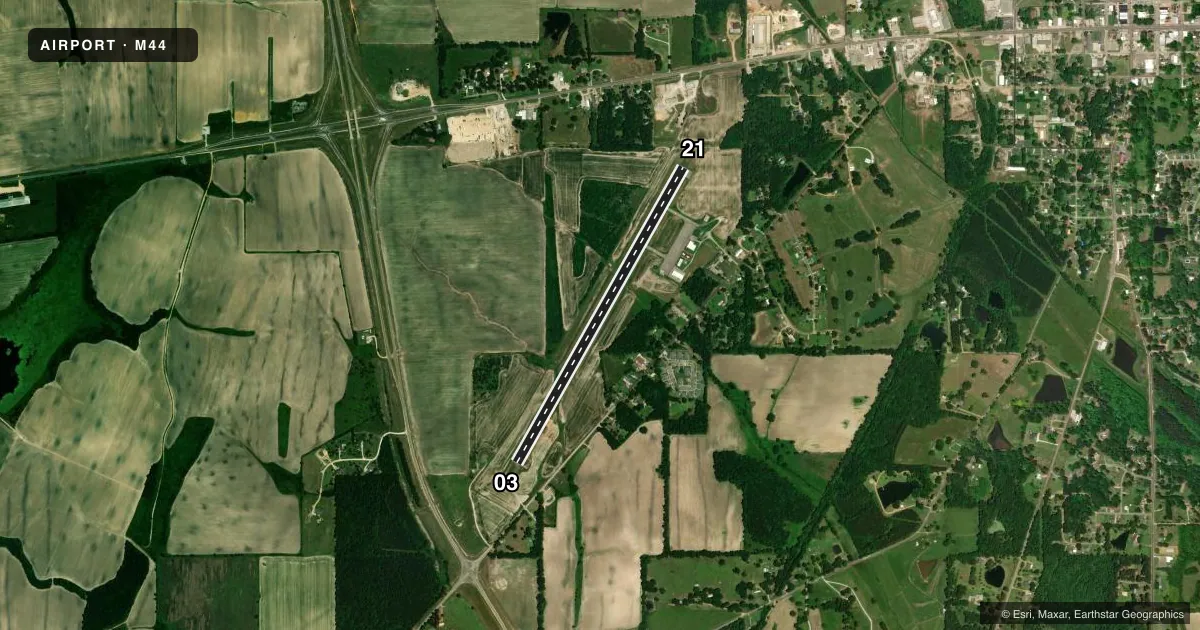
Runways & pattern
Full pagePattern entry · RWY 03
LEFT TRAFFICRunway end performance
| End | TORA | TODA | ASDA | LDA | VGSI | Approach lights | Obstruction |
|---|---|---|---|---|---|---|---|
| 03 | — | — | — | — | PAPI 2-box left(3°) | — | 65', trees, 1510' from thr, 0' R of cntrln, slope 20 |
| 21 | — | — | — | — | PAPI 2-box left(3°) | — | 48', trees, 1425' from thr, 200' R of cntrln, slope 25 |
Declared distances in feet. TORA = takeoff run available, TODA = takeoff distance, ASDA = accelerate-stop, LDA = landing distance.
Airport sketch
Runways drawn to scale from FAA survey coordinates, rendered over satellite imagery. Not for navigation.
Approaches & charts
Services on the field
Fuel grades, oxygen, maintenance, ramp storage and lighting — as declared to the FAA by the airport operator.
Fuel & services
- Fuel
- 100LL
- Oxygen (bottled)
- Not available
- Oxygen (bulk)
- Not available
- Airframe repair
- Minor
- Power plant repair
- Minor
- Other services
- AGRI
Ramp & ground
- Transient storage
- Tie-down
- Landing fee
- No fee published
- Customs
- Not available
- Lighting schedule
- SEE RMK
- Beacon schedule
- SS-SR
- Beacon
- White / Green (civil land)(WG)
- Wind indicator
- Lighted
- Segmented circle
- Yes
Fuel & FBOs
Cheapest 100LL and Jet A on the field and nearby. Always confirm with the FBO before taxi.
Airport notes
Surface conditions, obstructions, local procedures, lighting outages and other notes published with each FAA cycle.
General notes
- FOR CD CTC MEMPHIS ARTCC AT 901-368-8453/8449.
Lighting notes
- ACTVT MIRL 03/21 - CTAF. PAPI RWY 03 & 21 OPR CONSLY.
Fuel notes
- 100LLAVBL 24 HRS WITH CREDIT CARD.
Other notes
- PILOTS MUST PRVD TIEDOWN ROPES.
VFR map & nearby airports
VFR sectional. Tap any ICAO chip to open that airport.
Key facts · M44
Answer card- ICAO
- M44
- Name
- HOUSTON MUNI
- Location
- HOUSTON, MISSISSIPPI
- Elevation
- 337.2 ft MSL
- Traffic pattern altitude
- 1,337.2 ft MSL (1,000 AGL)
- Control tower
- Non-towered (use CTAF)
- Total runways
- 1
- Longest runway
- 03/21 · 4,400 ft
- Published ILS approaches
- 0
- Published frequencies
- 1
- Magnetic variation
- 2°
- Current flight rules
- VFR
- Current wind
- 070° at 5 kt
- Favored runway now
- RWY 03
Houston Muni is in Houston, Mississippi. The field elevation is 337.2 ft MSL. It has one runway, 03/21, which is 4,400 ft asphalt and the longest runway on the field. There is no control tower. CTAF is 122.9.
No ILS approaches are published here. The runway lighting is medium intensity on 03/21 and is controlled by CTAF. The PAPI on runways 03 and 21 operates continuously. 100LL is available 24 hours with a credit card. Pilots should also plan to bring tiedown ropes, since the Chart Supplement says they are required.
The pattern altitude is not published. Use the standard 1,000 ft AGL unless the current Chart Supplement says otherwise. Clearance delivery is handled through Memphis ARTCC, which is useful to have ready before departure if you need IFR service. This is a non-towered field, so expect self-announced traffic on CTAF and keep a close eye out in the pattern. Check the current Chart Supplement before flight for any updates to lighting, procedures, or local remarks.