METAR & TAF KSTF
Current METAR
Observed 13:35Z
KSTF 271335Z AUTO VRB06KT 10SM CLR 28/28 A2998 RMK AO2
- Wind
- VAR @ 6 kt
- Visibility
- 10 SM
- Temp / Dew
- 28°C / 28°C
- Altimeter
- 29.98 inHg
- Clouds
- CLR
- Density alt
- 1,898 ft
- Ceiling
- Unlimited
- Rules
- VFR
Airport info & contacts
Manager on record, flight service, ARTCC, attendance schedule and pattern altitude — published by the FAA and refreshed every 28 days.
Location
- From city
- 3 NM SW
- VFR sectional
- MEMPHIS
- ARTCC
- ZME · MEMPHIS
- NOTAM facility
- GWO (NOTAM-D)
Airport manager
- Name
- RODNEY LINCOLN
- Phone
- 662-418-5900
- Address
- PO BOX 1424, STARKVILLE MS 39760
Flight service · Hours
- FSS GWO
- GREENWOOD1-800-WX-BRIEF
- Attendance
- MON-SAT · 0800-1700
- SUN · 1300-1700
Frequencies
Tap any row to copy the frequency to your clipboard.
Runways & pattern
Full pagePattern entry · RWY 36
LEFT TRAFFICRunway end performance
| End | TORA | TODA | ASDA | LDA | VGSI | Approach lights | Obstruction |
|---|---|---|---|---|---|---|---|
| 18 | — | — | — | — | PAPI 2-box left(3°) | — | 32', sign, 900' from thr, 150' R of cntrln, slope 21 |
| 36 | — | — | — | — | PAPI 2-box left(3°) | — | — |
Declared distances in feet. TORA = takeoff run available, TODA = takeoff distance, ASDA = accelerate-stop, LDA = landing distance.
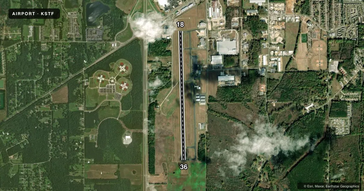
Airport sketch
Runways drawn to scale from FAA survey coordinates, rendered over satellite imagery. Not for navigation.
Approaches & charts
ILS · 1
Services on the field
Fuel grades, oxygen, maintenance, ramp storage and lighting — as declared to the FAA by the airport operator.
Fuel & services
- Fuel
- 100LLA
- Oxygen (bottled)
- Not available
- Oxygen (bulk)
- Not available
- Airframe repair
- Major
- Power plant repair
- Major
- Other services
- GLD,INSTR,RNTL,TOW
Ramp & ground
- Transient storage
- Tie-down
- Landing fee
- No fee published
- Customs
- Not available
- Lighting schedule
- SEE RMK
- Beacon schedule
- SS-SR
- Beacon
- White / Green (civil land)(WG)
- Wind indicator
- Lighted
- Segmented circle
- Yes
Fuel & FBOs
Cheapest 100LL and Jet A on the field and nearby. Always confirm with the FBO before taxi.
Airport notes
Surface conditions, obstructions, local procedures, lighting outages and other notes published with each FAA cycle.
General notes
- EXPERIMENTAL ACFT ON & INVOF ARPT.
- FOR CD CTC COLUMBUS APCH AT 662-434-3044.
- COURTESY CAR AVBL.
Lighting notes
- 0800-1630; AFT HR ACTVT REIL RWY 36; HIRL RWY 18/36 - CTAF. PAPI RWY 18 & 36 OPR CONSLY.
Fuel notes
- AFULL SVC AFT HRS - CTC AMGR. FUEL AVBL 24 HRS WITH CREDIT CARD.
Approach & departure obstructions
- 18APCH RATIO 49:1 FM DTHR.
Other notes
- PILOTS MUST PRVD TIEDOWN ROPES.
VFR map & nearby airports
VFR sectional. Tap any ICAO chip to open that airport.
Key facts · KSTF
Answer card- ICAO
- KSTF
- Name
- GEORGE M BRYAN
- Location
- STARKVILLE, MISSISSIPPI
- Elevation
- 332.6 ft MSL
- Traffic pattern altitude
- 1,332.6 ft MSL (1,000 AGL)
- Control tower
- Non-towered (use CTAF)
- Total runways
- 1
- Longest runway
- 18/36 · 5,550 ft
- Published ILS approaches
- 1
- Published frequencies
- 5
- Magnetic variation
- 1°
- Current flight rules
- VFR
- Current wind
- 000° at 6 kt
- Favored runway now
- RWY 36
George M Bryan Airport sits in Starkville, Mississippi. Field elevation is 332.6 ft MSL. It has one runway, 18/36, which is 5,550 ft long and paved asphalt-concrete. The airport is not towered. Pattern altitude is not published, so plan on the standard 1,000 ft AGL for light piston traffic unless the current Chart Supplement says otherwise. The field has one ILS approach to runway 36. Clearance delivery is handled through Columbus Approach.
Lighting is scheduled from 0800 to 1630. After hours, runway end identifier lights for runway 36 are active. The runway lights for 18 and 36 are high intensity and are controlled by CTAF. The PAPI for both runway ends operates continuously. A courtesy car is available. Experimental aircraft operate on and near the airport, so expect mixed traffic. There is also a published obstruction note for runway 18. The approach from the displaced threshold has a 49:1 slope, so brief your arrival carefully if you are using that end.
George M. Bryan Airport has one on-field FBO. George M. Bryan Airport carries 100LL and Jet A Prist. Fuel is available 24 hours with a credit card. After hours full service fuel is available by contacting the airport manager. Pilots must provide tiedown ropes.