METAR & TAF KLMS
Current METAR
Observed 12:35Z
KLMS 271235Z AUTO 34004KT 10SM CLR 27/24 A3003 RMK AO2
- Wind
- 340° @ 4 kt
- Visibility
- 10 SM
- Temp / Dew
- 27°C / 24°C
- Altimeter
- 30.03 inHg
- Clouds
- CLR
- Density alt
- 2,016 ft
- Ceiling
- Unlimited
- Rules
- VFR
Airport info & contacts
Manager on record, flight service, ARTCC, attendance schedule and pattern altitude — published by the FAA and refreshed every 28 days.
Location
- From city
- 1 NM N
- VFR sectional
- MEMPHIS
- ARTCC
- ZME · MEMPHIS
- NOTAM facility
- GWO (NOTAM-D)
Airport manager
- Name
- BOBBY SMITH
- Phone
- 662-705-4212
- Address
- PO BOX 1022, LOUISVILLE MS 39339
Flight service · Hours
- FSS GWO
- GREENWOOD1-800-WX-BRIEF
- Attendance
- Unattended
Frequencies
Tap any row to copy the frequency to your clipboard.
Runways & pattern
Full pagePattern entry · RWY 35
LEFT TRAFFICRunway end performance
| End | TORA | TODA | ASDA | LDA | VGSI | Approach lights | Obstruction |
|---|---|---|---|---|---|---|---|
| 17 | — | — | — | — | PAPI 2-box left(3.25°) | — | 41', trees, 1200' from thr, 0' R of cntrln, slope 24 |
| 35 | — | — | — | — | PAPI 2-box left(3°) | — | 50', trees, 1200' from thr, 200' R of cntrln, slope 20 |
Declared distances in feet. TORA = takeoff run available, TODA = takeoff distance, ASDA = accelerate-stop, LDA = landing distance.
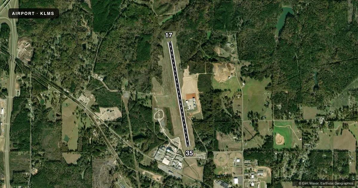
Airport sketch
Runways drawn to scale from FAA survey coordinates, rendered over satellite imagery. Not for navigation.
Approaches & charts
Services on the field
Fuel grades, oxygen, maintenance, ramp storage and lighting — as declared to the FAA by the airport operator.
Fuel & services
- Fuel
- 100LLA
- Oxygen (bottled)
- Not available
- Oxygen (bulk)
- Not available
- Other services
- AGRI,INSTR
Ramp & ground
- Transient storage
- Tie-down
- Landing fee
- No fee published
- Customs
- Not available
- Lighting schedule
- SEE RMK
- Beacon schedule
- SS-SR
- Beacon
- White / Green (civil land)(WG)
- Wind indicator
- Lighted
- Segmented circle
- Yes
Fuel & FBOs
Cheapest 100LL and Jet A on the field and nearby. Always confirm with the FBO before taxi.
Airport notes
Surface conditions, obstructions, local procedures, lighting outages and other notes published with each FAA cycle.
General notes
- FOR CD CTC MEMPHIS ARTCC AT 901-368-8453/8449.
- COURTESY CAR AVBL.
Lighting notes
- ACTVT MIRL RWY 17/35 - CTAF. PAPI RWY 17 & 35 OPR CONSLY.
Fuel notes
- 100LLFUEL AVBL 24 HRS WITH CREDIT CARD. ASSISTED SVC AVBL.
Other notes
- AUTOMATED UNICOM; 4 CLICKS WX ADZY.
- 1FOR SVC CTC AMGR.
VFR map & nearby airports
VFR sectional. Tap any ICAO chip to open that airport.
Key facts · KLMS
Answer card- ICAO
- KLMS
- Name
- LOUISVILLE/WINSTON COUNTY
- Location
- LOUISVILLE, MISSISSIPPI
- Elevation
- 574.5 ft MSL
- Traffic pattern altitude
- 1,574.5 ft MSL (1,000 AGL)
- Control tower
- Non-towered (use CTAF)
- Total runways
- 1
- Longest runway
- 17/35 · 4,669 ft
- Published ILS approaches
- 0
- Published frequencies
- 2
- Magnetic variation
- 0°
- Current flight rules
- VFR
- Current wind
- 340° at 4 kt
- Favored runway now
- RWY 35
Louisville/Winston County Airport sits in Louisville, Mississippi. The field elevation is 574.5 ft MSL. It has one runway, 17/35, which is 4,669 ft long with an asphalt surface. There is no control tower. CTAF and UNICOM are both 122.7. No ILS approaches are published.
The pattern altitude is not published. Use the standard 1,000 ft AGL pattern for light piston operations unless the current Chart Supplement says otherwise. The airport uses automated UNICOM. Four clicks get the weather advisory. Medium intensity runway lights on 17/35 are activated by CTAF. The PAPI on runways 17 and 35 operate continuously.
Louisville-Winston Co. Airport is the on-field FBO. It carries 100LL and Jet A. Fuel is available 24 hours with credit card. Assisted service is available. A courtesy car is available. For service contact the airport manager. For clearance delivery contact Memphis ARTCC. First-time pilots should plan for an uncontrolled field with local CTAF traffic flow. Check the current Chart Supplement for any published noise or curfew restrictions before flying in.