METAR & TAF KOSX
KOSX does not publish a METAR.
Showing the nearest reporting station: KLMS (LOUISVILLE/WINSTON COUNTY) · 24.3 NM away. Conditions at KOSX may differ.
METAR · KLMS
Observed 16:35Z
KLMS 271635Z AUTO 29007KT 270V340 10SM CLR 32/25 A2998 RMK AO2
- Wind
- 290° @ 7 kt
- Visibility
- 10 SM
- Temp / Dew
- 32°C / 25°C
- Altimeter
- 29.98 inHg
- Clouds
- CLR
- Density alt
- 2,579 ft
- Ceiling
- Unlimited
- Rules
- VFR
Airport info & contacts
Manager on record, flight service, ARTCC, attendance schedule and pattern altitude — published by the FAA and refreshed every 28 days.
Location
- From city
- 3 NM NE
- VFR sectional
- MEMPHIS
- ARTCC
- ZME · MEMPHIS
- NOTAM facility
- GWO (NOTAM-D)
Airport manager
- Name
- RICHIE ARMSTRONG
- Phone
- 662-289-1226
- Address
- 220 W WASHINGTON ST, KOSCIUSKO MS 39090
Flight service · Hours
- FSS GWO
- GREENWOOD1-800-WX-BRIEF
- Attendance
- Unattended
Frequencies
Tap any row to copy the frequency to your clipboard.
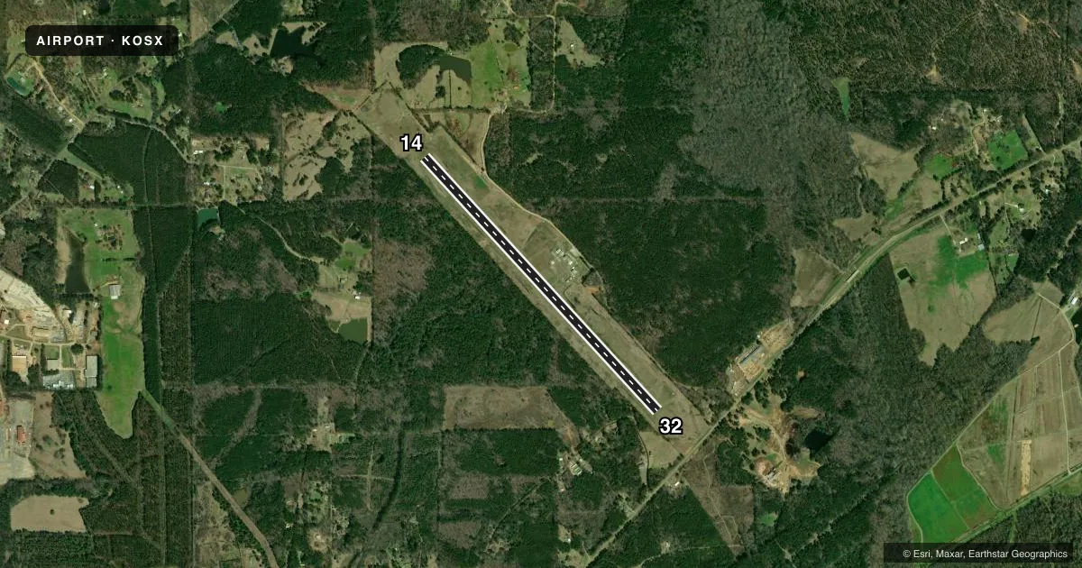
Runways & pattern
Full pagePattern entry · RWY 32
LEFT TRAFFICRunway end performance
| End | TORA | TODA | ASDA | LDA | VGSI | Approach lights | Obstruction |
|---|---|---|---|---|---|---|---|
| 14 | — | — | — | — | PAPI 2-box left(3.5°) | — | 56', trees, 1680' from thr, 0' R of cntrln, slope 26 |
| 32 | — | — | — | — | PAPI 2-box left(3.5°) | — | 46', trees, 1175' from thr, 40' R of cntrln, slope 21 |
Declared distances in feet. TORA = takeoff run available, TODA = takeoff distance, ASDA = accelerate-stop, LDA = landing distance.
Airport sketch
Runways drawn to scale from FAA survey coordinates, rendered over satellite imagery. Not for navigation.
Approaches & charts
Services on the field
Fuel grades, oxygen, maintenance, ramp storage and lighting — as declared to the FAA by the airport operator.
Fuel & services
- Fuel
- 100LLA
- Other services
- AGRI,INSTR
Ramp & ground
- Transient storage
- Tie-down
- Landing fee
- No fee published
- Customs
- Not available
- Lighting schedule
- SEE RMK
- Beacon schedule
- SS-SR
- Beacon
- White / Green (civil land)(WG)
- Wind indicator
- Lighted
- Segmented circle
- Yes
Fuel & FBOs
Cheapest 100LL and Jet A on the field and nearby. Always confirm with the FBO before taxi.
Airport notes
Surface conditions, obstructions, local procedures, lighting outages and other notes published with each FAA cycle.
General notes
- FOR CD CTC MEMPHIS ARTCC AT 901-368-8453/8449.
- COURTESY CAR AVBL.
Lighting notes
- ACTVT MIRL RWY 14/32 - CTAF. PAPI RWY 14 & 32 OPR CONSLY.
Fuel notes
- 100LLSELF SVC AVBL 24 HRS VIA CREDIT CARD.
Approach & departure obstructions
- 14RC MODEL AIRPLANE FLYING OFF RWY END.
VFR map & nearby airports
VFR sectional. Tap any ICAO chip to open that airport.
Key facts · KOSX
Answer card- ICAO
- KOSX
- Name
- KOSCIUSKO-ATTALA COUNTY
- Location
- KOSCIUSKO, MISSISSIPPI
- Elevation
- 494.4 ft MSL
- Traffic pattern altitude
- 1,494.4 ft MSL (1,000 AGL)
- Control tower
- Non-towered (use CTAF)
- Total runways
- 1
- Longest runway
- 14/32 · 5,009 ft
- Published ILS approaches
- 0
- Published frequencies
- 1
- Magnetic variation
- 0°
- Current flight rules
- VFR
- Current wind
- 290° at 7 kt
- Favored runway now
- RWY 32
Kosciusko-Attala County Airport (KOSX) sits in Kosciusko, Mississippi. Field elevation is 494.4 ft MSL. The airport has one runway, 14/32, which is 5,009 ft long on asphalt. There is no control tower. CTAF is 122.9.
No ILS approaches are published here. Pattern altitude is not published, so use the standard 1,000 ft AGL for light piston traffic unless the current Chart Supplement says otherwise. The published remarks matter here. Runway 14/32 medium intensity lights are pilot-controlled through the CTAF. The PAPI for both runway ends operates continuously. Self-service 100LL is available 24 hours by credit card. A courtesy car is also available.
There are no on-field FBOs listed in the facts. Contact the airport operator directly or call the field on CTAF for current services before you go. For clearance delivery, Memphis ARTCC is the published contact. One operational note for planning. Radio-controlled model airplanes are flown off the runway end at runway 14. Keep that in mind during taxi, takeoff and landing planning.