METAR & TAF KGNF
KGNF does not publish a METAR.
Showing the nearest reporting station: KGWO (GREENWOOD-LEFLORE) · 24.9 NM away. Conditions at KGNF may differ.
METAR · KGWO
Observed 12:53Z
KGWO 271253Z AUTO 00000KT 10SM CLR 27/24 A2998 RMK AO2 SLP148 T02670244
- Wind
- 000° @ 0 kt
- Visibility
- 10 SM
- Temp / Dew
- 27°C / 24°C
- Altimeter
- 29.98 inHg
- Clouds
- CLR
- Density alt
- 1,623 ft
- Ceiling
- Unlimited
- Rules
- VFR
Airport info & contacts
Manager on record, flight service, ARTCC, attendance schedule and pattern altitude — published by the FAA and refreshed every 28 days.
Location
- From city
- 3 NM N
- VFR sectional
- MEMPHIS
- ARTCC
- ZME · MEMPHIS
- NOTAM facility
- GWO (NOTAM-D)
Airport manager
- Name
- RANDY ADAMS
- Phone
- 662-227-8402
- Address
- PO BOX 310, GRENADA MS 38902
Flight service · Hours
- FSS GWO
- GREENWOOD1-800-WX-BRIEF
- Attendance
- MON-SAT · ON CALL
- SUN · 1300-1700
Frequencies
Tap any row to copy the frequency to your clipboard.
Runways & pattern
Full pagePattern entry · RWY 13
LEFT TRAFFIC| Runway | Heading (°M) | Length | Surface | Traffic |
|---|---|---|---|---|
| 13/31 | 131° / 311° | 7,000 ft | ASPH | Standard L |
| 04/22 | 51° / 231° | 4,998 ft | ASPH | Standard L |
Runway end performance
| End | TORA | TODA | ASDA | LDA | VGSI | Approach lights | Obstruction |
|---|---|---|---|---|---|---|---|
| 13 | — | — | — | — | VASI 4-box left(3°) | MALSR | — |
| 31 | — | — | — | — | VASI 4-box left(3°) | — | 76', trees, 2350' from thr, 0' R of cntrln, slope 27 |
| 04 | — | — | — | — | — | — | 59', trees, 1350' from thr, 0' R of cntrln, slope 19 |
| 22 | — | — | — | — | — | — | 15', road, 200' from thr, 225' R of cntrln, slope 0 |
Declared distances in feet. TORA = takeoff run available, TODA = takeoff distance, ASDA = accelerate-stop, LDA = landing distance.
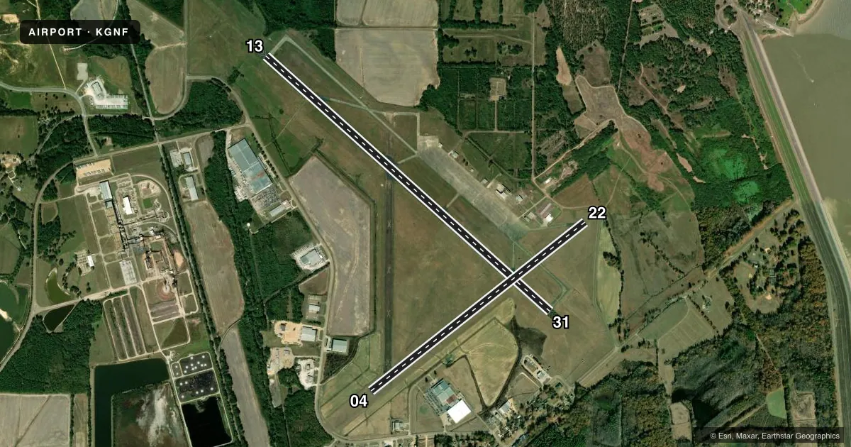
Airport sketch
Runways drawn to scale from FAA survey coordinates, rendered over satellite imagery. Not for navigation.
Approaches & charts
Services on the field
Fuel grades, oxygen, maintenance, ramp storage and lighting — as declared to the FAA by the airport operator.
Fuel & services
- Fuel
- 100LLA
- Oxygen (bottled)
- Not available
- Oxygen (bulk)
- Not available
- Other services
- AGRI
Ramp & ground
- Transient storage
- Tie-down
- Landing fee
- No fee published
- Customs
- Not available
- Lighting schedule
- SS-SR
- Beacon schedule
- SS-SR
- Beacon
- White / Green (civil land)(WG)
- Wind indicator
- Lighted
- Segmented circle
- Yes
Fuel & FBOs
Cheapest 100LL and Jet A on the field and nearby. Always confirm with the FBO before taxi.
Airport notes
Surface conditions, obstructions, local procedures, lighting outages and other notes published with each FAA cycle.
General notes
- EXTSV AGRICULTURE OPS INVOF ARPT SR-SS MAR-OCT.
- BIRDS & DEER INVOF ARPT.
- AEROBATIC ACFT DALGT HRS; 7000 FT & BLW WITHIN 3 NM OF ARPT.
- FOR CD CTC MEMPHIS ARTCC AT 901-368-8453/8449.
- ILS DCMSND.
Runway surface & condition
- 13/31200 FT BY 150 FT ASPH OVRN AVBL.
Approach & departure obstructions
- 22PAVED RD 200 FT FM RWY END 225 FT R & 167 FT L.
- 04FADED.
- 22FADED.
- 22APCH RATIO 28:1 TO DTHR.
Other notes
- THIS AIRPORT HAS BEEN SURVEYED BY THE NATIONAL GEODETIC SURVEY.
- PRIOR TO FAA ACT.
- PILOTS MUST PRVD THEIR OWN TIEDOWN ROPES.
- 1662-230-3646.
- 1FOR FUEL CALL 662-230-3646.
- 04/22ASPH CRACKED & HAS DEPRESSIONS.
VFR map & nearby airports
VFR sectional. Tap any ICAO chip to open that airport.
Key facts · KGNF
Answer card- ICAO
- KGNF
- Name
- GRENADA MUNI
- Location
- GRENADA, MISSISSIPPI
- Elevation
- 207.9 ft MSL
- Traffic pattern altitude
- 1,207.9 ft MSL (1,000 AGL)
- Control tower
- Non-towered (use CTAF)
- Total runways
- 2
- Longest runway
- 13/31 · 7,000 ft
- Published ILS approaches
- 0
- Published frequencies
- 2
- Magnetic variation
- 1°
- Current flight rules
- VFR
- Current wind
- 000° at 0 kt
- Favored runway now
- –
Grenada Muni is in Grenada, Mississippi. The field elevation is 207.9 ft MSL. It has two asphalt runways. The longest is runway 13/31 at 7,000 ft. There is no control tower, so expect non-towered traffic flow on CTAF 122.8. Pattern altitude is not published. Use the standard 1,000 ft AGL unless the current Chart Supplement says otherwise.
No ILS approaches are published here. The ILS is also decommissioned. For IFR planning, check the current Chart Supplement before you go. The on-field FBO is Grenada Municipal Airport. It carries 100LL, Jet A and Jet A Prist. The airport remarks also note that pilots must provide their own tiedown ropes.
A few field notes matter here. Runway 04/22 has cracked asphalt and depressions. Runway 22 has faded markings. There is a paved road close off the runway 22 end. Birds and deer are reported in the area. Agricultural activity is also common from sunrise to sunset March through October. Runway 13/31 has a 200-foot by 150-foot asphalt overrun. For clearance delivery, contact Memphis ARTCC. If you are new to the airport, brief the runway condition, wildlife and the non-towered pattern before arrival.