METAR & TAF 33M
33M does not publish a METAR.
Showing the nearest reporting station: KUOX (UNIVERSITY-OXFORD) · 14.9 NM away. Conditions at 33M may differ.
METAR · KUOX
Observed 13:35Z
KUOX 271335Z AUTO 09003KT 10SM SCT050 28/24 A3002 RMK AO2
- Wind
- 090° @ 3 kt
- Visibility
- 10 SM
- Temp / Dew
- 28°C / 24°C
- Altimeter
- 30.02 inHg
- Clouds
- SCT
- Density alt
- 1,771 ft
- Ceiling
- Unlimited
- Rules
- VFR
Airport info & contacts
Manager on record, flight service, ARTCC, attendance schedule and pattern altitude — published by the FAA and refreshed every 28 days.
Location
- From city
- 3 NM NW
- VFR sectional
- MEMPHIS
- ARTCC
- ZME · MEMPHIS
- NOTAM facility
- GWO (NOTAM-D)
Airport manager
- Name
- MICHAEL SCROGGINS
- Phone
- 662-473-7676
- Address
- CITY HALL BOX 888, WATER VALLEY MS 38965
Flight service · Hours
- FSS GWO
- GREENWOOD1-800-WX-BRIEF
- Attendance
- ON CALL
Frequencies
Tap any row to copy the frequency to your clipboard.
Runways & pattern
Full pagePattern entry · RWY 15
LEFT TRAFFICRunway end performance
| End | TORA | TODA | ASDA | LDA | VGSI | Approach lights | Obstruction |
|---|---|---|---|---|---|---|---|
| 15 | — | — | — | — | PAPI 2-box left(3°) | — | — |
| 33 | — | — | — | — | PAPI 2-box left(3°) | — | 35', tree, 1020' from thr, 200' R of cntrln, slope 23 |
Declared distances in feet. TORA = takeoff run available, TODA = takeoff distance, ASDA = accelerate-stop, LDA = landing distance.
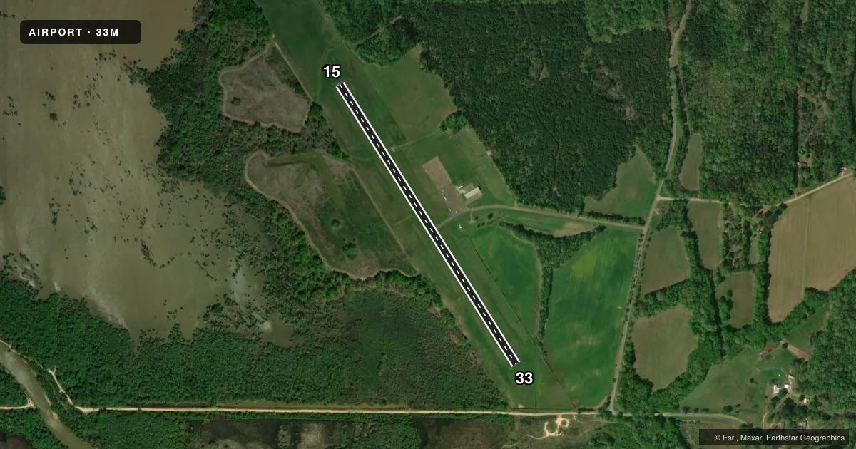
Airport sketch
Runways drawn to scale from FAA survey coordinates, rendered over satellite imagery. Not for navigation.
Approaches & charts
Services on the field
Fuel grades, oxygen, maintenance, ramp storage and lighting — as declared to the FAA by the airport operator.
Fuel & services
- Fuel
- 100LL
- Oxygen (bottled)
- Not available
- Oxygen (bulk)
- Not available
- Airframe repair
- Not available
- Power plant repair
- Not available
- Other services
- INSTR
Ramp & ground
- Transient storage
- Tie-down
- Landing fee
- No fee published
- Customs
- Not available
- Lighting schedule
- SEE RMK
- Beacon schedule
- SS-SR
- Beacon
- White / Green (civil land)(WG)
- Wind indicator
- Lighted
- Segmented circle
- No
Fuel & FBOs
Cheapest 100LL and Jet A on the field and nearby. Always confirm with the FBO before taxi.
Airport notes
Surface conditions, obstructions, local procedures, lighting outages and other notes published with each FAA cycle.
General notes
- LRG FLOCKS OF DUCKS OVR LAKE.
- FOR CD CTC MEMPHIS ARTCC AT 901-368-8453/8449.
Lighting notes
- LIRL RWY 15/33 PRESET LOW INTST; TO INCR - CTAF. PAPIS OPER CONSLY.
Fuel notes
- 100LLFUEL AVBL 24 HRS WITH CREDIT CARD.
Other notes
- PILOTS MUST PRVD THEIR OWN TIE ROPES.
- 1FOR PART TIME ATTENDANT CALL 662-473-7676.
- MANAGERAFT HRS CALL 662-473-7676.
- INSTRAVBL O/R.
VFR map & nearby airports
VFR sectional. Tap any ICAO chip to open that airport.
Key facts · 33M
Answer card- ICAO
- 33M
- Name
- WATER VALLEY MUNI
- Location
- WATER VALLEY, MISSISSIPPI
- Elevation
- 269.9 ft MSL
- Traffic pattern altitude
- 1,269.9 ft MSL (1,000 AGL)
- Control tower
- Non-towered (use CTAF)
- Total runways
- 1
- Longest runway
- 15/33 · 3,000 ft
- Published ILS approaches
- 0
- Published frequencies
- 1
- Magnetic variation
- 2°
- Current flight rules
- VFR
- Current wind
- 090° at 3 kt
- Favored runway now
- RWY 15
Water Valley Muni sits in Water Valley, Mississippi. Field elevation is 269.9 ft MSL. The airport has one runway. Runway 15/33 is 3,000 ft of asphalt with magnetic headings 148° and 328°. There is no control tower. CTAF is 122.9. No ILS approaches are published here.
Pattern altitude is not published. Use 1,000 ft AGL for light piston ops unless the current Chart Supplement says otherwise. That puts the traffic pattern at about 1,270 ft MSL based on the field elevation. The airport notes low intensity runway lights on 15/33. They are preset. Use CTAF to increase intensity. Precision approach path indicators operate continuously.
No on-field FBOs are listed in the facts. Fuel 100LL is available 24 hours with credit card. Tie ropes are not provided, so bring your own. Large flocks of ducks are reported over the lake. That is worth keeping in mind on departure and arrival. For clearance delivery, contact Memphis ARTCC. For part-time attendant or after-hours help, call the number in the Chart Supplement. This is a non-towered field, so plan your self-announce calls and check the current Chart Supplement for any local procedures before you go.