METAR & TAF KMMS
KMMS does not publish a METAR.
Showing the nearest reporting station: KCKM (FLETCHER FLD) · 11.8 NM away. Conditions at KMMS may differ.
METAR · KCKM
Observed 14:55Z
KCKM 161455Z AUTO RMK A01 PNO
- Wind
- Calm
- Visibility
- —
- Temp / Dew
- —
- Altimeter
- —
- Clouds
- Clear
- Density alt
- —
- Ceiling
- Unlimited
- Rules
- VFR
Airport info & contacts
Manager on record, flight service, ARTCC, attendance schedule and pattern altitude — published by the FAA and refreshed every 28 days.
Location
- From city
- 2 NM SW
- VFR sectional
- MEMPHIS
- ARTCC
- ZME · MEMPHIS
- NOTAM facility
- GWO (NOTAM-D)
Airport manager
- Name
- KEVIN RUSHING
- Phone
- 662-444-4736
- Address
- 733 AIRPORT RD, PO BOX 370, MARKS MS 38646
Flight service · Hours
- FSS GWO
- GREENWOOD1-800-WX-BRIEF
- Attendance
- MON-FRI · 0800-1700
- SAT-SUN · IRREG
Frequencies
Tap any row to copy the frequency to your clipboard.
Runways & pattern
Full pagePattern entry · RWY 02
LEFT TRAFFICRunway end performance
| End | TORA | TODA | ASDA | LDA | VGSI | Approach lights | Obstruction |
|---|---|---|---|---|---|---|---|
| 20 | — | — | — | — | — | — | 71', trees, 1750' from thr, 300' R of cntrln, slope 20 |
Declared distances in feet. TORA = takeoff run available, TODA = takeoff distance, ASDA = accelerate-stop, LDA = landing distance.
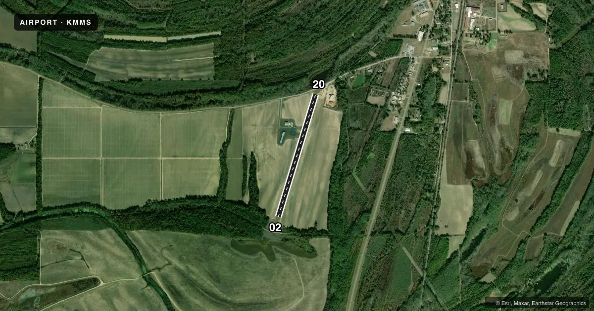
Airport sketch
Runways drawn to scale from FAA survey coordinates, rendered over satellite imagery. Not for navigation.
Approaches & charts
Services on the field
Fuel grades, oxygen, maintenance, ramp storage and lighting — as declared to the FAA by the airport operator.
Fuel & services
- Fuel
- Not available
- Oxygen (bottled)
- Not available
- Oxygen (bulk)
- Not available
- Airframe repair
- Major
- Power plant repair
- Major
- Other services
- AGRI
Ramp & ground
- Transient storage
- Tie-down
- Landing fee
- No fee published
- Lighting schedule
- SS-SR
- Wind indicator
- Yes
- Segmented circle
- No
Fuel & FBOs
Cheapest 100LL and Jet A on the field and nearby. Always confirm with the FBO before taxi.
Airport notes
Surface conditions, obstructions, local procedures, lighting outages and other notes published with each FAA cycle.
General notes
- FOR CD CTC MEMPHIS ARTCC AT 901-368-8453/8449.
Approach & departure obstructions
- 20PAVED RD 160 FT FM THR.
- 02MARKINGS BADLY FADED.
Other notes
- PILOTS MUST PRVD THEIR OWN TIEDOWN ROPES.
- 3FOR ATNDNC HRS SAT & SUN CALL 662-444-4736.
VFR map & nearby airports
VFR sectional. Tap any ICAO chip to open that airport.
Key facts · KMMS
Answer card- ICAO
- KMMS
- Name
- SELFS
- Location
- MARKS, MISSISSIPPI
- Elevation
- 161.7 ft MSL
- Traffic pattern altitude
- 1,161.7 ft MSL (1,000 AGL)
- Control tower
- Non-towered (use CTAF)
- Total runways
- 1
- Longest runway
- 02/20 · 3,346 ft
- Published ILS approaches
- 0
- Published frequencies
- 1
- Magnetic variation
- 1°
- Current flight rules
- VFR
- Current wind
- Calm / unavailable
- Favored runway now
- –
SELFS sits near Marks, Mississippi. Field elevation is 161.7 ft MSL. The airport has one runway, 02/20, which is 3,346 ft long and asphalt. There is no control tower. CTAF is 122.9.
No ILS approaches are published here. Pattern altitude is not published, so plan on the standard 1,000 ft AGL for light piston traffic unless the current Chart Supplement says otherwise. Runway 02 markings are badly faded, so give yourself extra time to confirm the threshold and centerline before you turn final. There is also a paved road about 160 ft from the runway 20 threshold. That is worth keeping in mind on short final.
There are no on-field FBOs listed. Pilots must provide their own tiedown ropes. For clearance delivery, contact Memphis ARTCC at 901-368-8453 or 901-368-8449. For attendance hours on Saturday and Sunday, call 662-444-4736. This is a small non-towered field, so expect local traffic discipline on CTAF and verify any current field notes with the airport operator before you go.