METAR & TAF KHEE
KHEE does not publish a METAR.
Showing the nearest reporting station: KUTA (TUNICA MUNI) · 17.5 NM away. Conditions at KHEE may differ.
METAR · KUTA
Observed 16:15Z
KUTA 271615Z AUTO 22004KT 10SM FEW380 33/27 A2994 RMK AO2 T03350270 $
- Wind
- 220° @ 4 kt
- Visibility
- 10 SM
- Temp / Dew
- 33°C / 27°C
- Altimeter
- 29.94 inHg
- Clouds
- FEW
- Density alt
- 2,435 ft
- Ceiling
- Unlimited
- Rules
- VFR
Airport info & contacts
Manager on record, flight service, ARTCC, attendance schedule and pattern altitude — published by the FAA and refreshed every 28 days.
Location
- From city
- 5 NM NW
- VFR sectional
- MEMPHIS
- Pattern altitude
- 960 ft AGL · 1,202 ft MSL
- ARTCC
- ZME · MEMPHIS
- NOTAM facility
- JBR (NOTAM-D)
Airport manager
- Name
- BILL BROTHERS
- Phone
- 870-714-1844
- Address
- PO BOX 2948, WEST HELENA AR 72390
Flight service · Hours
- FSS JBR
- JONESBORO1-800-WX-BRIEF
- Attendance
- MON-FRI · DALGT
- SAT · 0800-1200
Frequencies
Tap any row to copy the frequency to your clipboard.
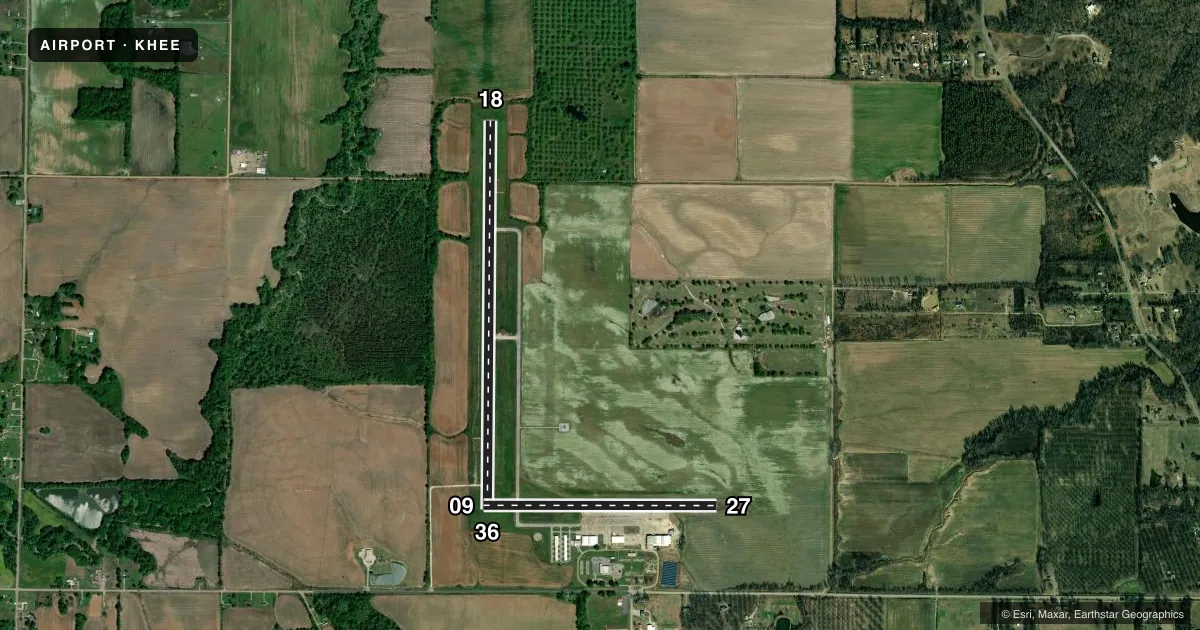
Runways & pattern
Full pagePattern entry · RWY 18
LEFT TRAFFIC| Runway | Heading (°M) | Length | Surface | Traffic |
|---|---|---|---|---|
| 18/36Favored | 179° / 359° | 5,001 ft | ASPH | Standard L |
| 09/27 | 89° / 269° | 3,011 ft | ASPH | Standard L |
Runway end performance
| End | TORA | TODA | ASDA | LDA | VGSI | Approach lights | Obstruction |
|---|---|---|---|---|---|---|---|
| 18 | — | — | — | — | PAPI 4-box left(3°) | — | — |
| 36 | — | — | — | — | PAPI 4-box left(3°) | — | — |
| 09 | — | — | — | — | — | — | 25', tree, 725' from thr, 115' R of cntrln, slope 20 |
Declared distances in feet. TORA = takeoff run available, TODA = takeoff distance, ASDA = accelerate-stop, LDA = landing distance.
Airport sketch
Runways drawn to scale from FAA survey coordinates, rendered over satellite imagery. Not for navigation.
Approaches & charts
Services on the field
Fuel grades, oxygen, maintenance, ramp storage and lighting — as declared to the FAA by the airport operator.
Fuel & services
- Fuel
- 100LLA
- Oxygen (bottled)
- Not available
- Oxygen (bulk)
- Not available
- Airframe repair
- Major
- Power plant repair
- Major
- Other services
- AGRI,INSTR,SALES
Ramp & ground
- Transient storage
- Tie-down
- Hangar
- Landing fee
- No fee published
- Customs
- Not available
- Lighting schedule
- SEE RMK
- Beacon schedule
- SS-SR
- Beacon
- White / Green (civil land)(WG)
- Wind indicator
- Lighted
- Segmented circle
- Yes
Fuel & FBOs
Cheapest 100LL and Jet A on the field and nearby. Always confirm with the FBO before taxi.
Airport notes
Surface conditions, obstructions, local procedures, lighting outages and other notes published with each FAA cycle.
General notes
- (E81) TWY EXIT & GUIDANCE SIGNS.
- NUMEROUS AGRICULTURE OPS FEB THRU OCT.
- FOR CD CTC MEMPHIS ARTCC AT 901-368-8453/8449.
Lighting notes
- ACTVT MIRL RWY 09/27 & 18/36 - CTAF. PAPI RWY 18 & 36 ON CONSLY.
VFR map & nearby airports
VFR sectional. Tap any ICAO chip to open that airport.
Key facts · KHEE
Answer card- ICAO
- KHEE
- Name
- THOMPSON-ROBBINS
- Location
- HELENA/WEST HELENA, ARKANSAS
- Elevation
- 241.7 ft MSL
- Traffic pattern altitude
- 1,201.7 ft MSL (960 AGL)
- Control tower
- Non-towered (use CTAF)
- Total runways
- 2
- Longest runway
- 18/36 · 5,001 ft
- Published ILS approaches
- 0
- Published frequencies
- 2
- Magnetic variation
- 1°
- Current flight rules
- VFR
- Current wind
- 220° at 4 kt
- Favored runway now
- RWY 18
Thompson-Robbins sits in Helena/West Helena, Arkansas. Field elevation is 241.7 ft MSL. The airport has two asphalt runways. The longest is 18/36 at 5,001 ft. There is no control tower. CTAF and UNICOM are both 122.8.
Pattern altitude is 960 ft AGL. That puts the traffic pattern at 1,201.7 ft MSL. No ILS approaches are published here, so plan your arrival with the current chart and your own situational awareness. South Delta Aviation is on the field. It carries 100LL and Jet A Prist. Their phone is (870) 572-9011.
Published remarks matter here. Medium intensity runway lights on 09/27 and 18/36 are activated by using the common traffic advisory frequency. Precision approach path indicators are on continuously for runways 18 and 36. Memphis ARTCC handles clearance delivery. The published numbers are 901-368-8453 and 901-368-8449. Expect a lot of agriculture traffic from February through October. Taxiway exit and guidance signs are present. For a first visit, treat this as a non-towered field with active local traffic, seasonal ag operations and a long enough primary runway for most general aviation arrivals. Check the current FAA Chart Supplement for any other operating notes before you go.