METAR & TAF KFCY
KFCY does not publish a METAR.
Showing the nearest reporting station: KDRP (DELTA RGNL) · 11.0 NM away. Conditions at KFCY may differ.
METAR · KDRP
Observed 13:35Z
KDRP 271335Z AUTO 06009KT 10SM FEW060 29/26 A2997 RMK AO2
- Wind
- 060° @ 9 kt
- Visibility
- 10 SM
- Temp / Dew
- 29°C / 26°C
- Altimeter
- 29.97 inHg
- Clouds
- FEW
- Density alt
- 1,927 ft
- Ceiling
- Unlimited
- Rules
- VFR
Airport info & contacts
Manager on record, flight service, ARTCC, attendance schedule and pattern altitude — published by the FAA and refreshed every 28 days.
Location
- From city
- 4 NM S
- VFR sectional
- MEMPHIS
- ARTCC
- ZME · MEMPHIS
- NOTAM facility
- JBR (NOTAM-D)
Airport manager
- Name
- GIL GILBREATH
- Phone
- 870-633-4511
- Address
- BOX 1296 HWY 980, FORREST CITY AR 72335
Flight service · Hours
- FSS JBR
- JONESBORO1-800-WX-BRIEF
- Attendance
- MON-FRI · 0800-1700
Frequencies
Tap any row to copy the frequency to your clipboard.
Runways & pattern
Full pagePattern entry · RWY 36
LEFT TRAFFICRunway end performance
| End | TORA | TODA | ASDA | LDA | VGSI | Approach lights | Obstruction |
|---|---|---|---|---|---|---|---|
| 18 | — | — | — | — | PAPI 2-box left(4°) | — | — |
| 36 | — | — | — | — | PAPI 2-box right(4°) | — | 30', trees, 1200' from thr, 225' R of cntrln, slope 33 |
Declared distances in feet. TORA = takeoff run available, TODA = takeoff distance, ASDA = accelerate-stop, LDA = landing distance.
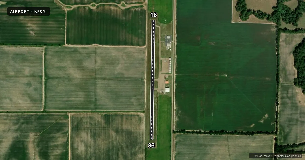
Airport sketch
Runways drawn to scale from FAA survey coordinates, rendered over satellite imagery. Not for navigation.
Approaches & charts
Services on the field
Fuel grades, oxygen, maintenance, ramp storage and lighting — as declared to the FAA by the airport operator.
Fuel & services
- Fuel
- A
- Airframe repair
- Major
- Power plant repair
- Major
- Other services
- AGRI
Ramp & ground
- Transient storage
- Tie-down
- Hangar
- Landing fee
- No fee published
- Customs
- Not available
- Lighting schedule
- SEE RMK
- Beacon schedule
- SS-SR
- Beacon
- White / Green (civil land)(WG)
- Wind indicator
- Lighted
- Segmented circle
- Yes
Fuel & FBOs
Cheapest 100LL and Jet A on the field and nearby. Always confirm with the FBO before taxi.
Airport notes
Surface conditions, obstructions, local procedures, lighting outages and other notes published with each FAA cycle.
General notes
- 494 FT LGTD TWR 3 MILES NORTH ON CNTRLN.
- RY 36 DITCH 201 FT FROM SOUTH END OF RY.
- FOR CD CTC MEMPHIS APCH AT 901-842-8457.
Lighting notes
- ROTG BCN OTS INDEFLY.
- DUSK-DAWN. ACTVT PAPI RWY 18 & 36; MIRL RWY 18/36 - CTAF.
Approach & departure obstructions
- 18REIL RWY 18/36 OTS INDEFLY.
- 18PAPI RWY 18/36 OTS INDEFLY.
Other notes
- THIS AIRPORT HAS BEEN SURVEYED BY THE NATIONAL GEODETIC SURVEY.
VFR map & nearby airports
VFR sectional. Tap any ICAO chip to open that airport.
Key facts · KFCY
Answer card- ICAO
- KFCY
- Name
- HUTFLY
- Location
- FORREST CITY, ARKANSAS
- Elevation
- 249.2 ft MSL
- Traffic pattern altitude
- 1,249.2 ft MSL (1,000 AGL)
- Control tower
- Non-towered (use CTAF)
- Total runways
- 1
- Longest runway
- 18/36 · 3,014 ft
- Published ILS approaches
- 0
- Published frequencies
- 2
- Magnetic variation
- 1°
- Current flight rules
- VFR
- Current wind
- 060° at 9 kt
- Favored runway now
- RWY 36
HUTFLY is in Forrest City, Arkansas. Field elevation is 249.2 ft MSL. The airport has one runway. Runway 18/36 is 3,014 ft long with asphalt surface. The field is non-towered. CTAF and UNICOM are both 122.8. No ILS approaches are published here.
Pattern altitude is not published. Use 1,000 ft AGL as the standard light piston pattern unless the current Chart Supplement says otherwise. The runway headings are 181° and 1° magnetic. That matters when you brief the wind and your entry.
Hutcherson Flying Service is on the field. It carries JET_A. Call (870) 633-4511 for current services before you go. Published remarks also note a few items that matter in the pattern. The PAPI on runways 18 and 36 is out of service indefinitely. The runway end identifier lights on both ends are also out of service indefinitely. Runway 36 has a ditch 201 ft from the south end. There is also a 494 ft lighted tower 3 miles north on the centerline. Lighting is available from dusk to dawn. Medium intensity runway lights are controlled by CTAF. For clearance delivery, contact Memphis Approach at 901-842-8457. This is a flat Arkansas field. Watch your arrival spacing. Keep the tower and ditch in mind on final.