METAR & TAF KDRP
Current METAR
Observed 15:15Z
KDRP 271515Z AUTO 00000KT 10SM CLR 32/25 A2995 RMK AO2
- Wind
- 000° @ 0 kt
- Visibility
- 10 SM
- Temp / Dew
- 32°C / 25°C
- Altimeter
- 29.95 inHg
- Clouds
- CLR
- Density alt
- 2,299 ft
- Ceiling
- Unlimited
- Rules
- VFR
Airport info & contacts
Manager on record, flight service, ARTCC, attendance schedule and pattern altitude — published by the FAA and refreshed every 28 days.
Location
- From city
- 1 NM SW
- VFR sectional
- MEMPHIS
- ARTCC
- ZME · MEMPHIS
- NOTAM facility
- JBR (NOTAM-D)
Airport manager
- Name
- SHANNON HOBBS
- Phone
- 870-633-6083
- Address
- P. O. BOX 267, COLT AR 72326
Flight service · Hours
- FSS JBR
- JONESBORO1-800-WX-BRIEF
- Attendance
- MON-FRI · 0700-1630
Frequencies
Tap any row to copy the frequency to your clipboard.
Runways & pattern
Full pagePattern entry · RWY 18
LEFT TRAFFICRunway end performance
| End | TORA | TODA | ASDA | LDA | VGSI | Approach lights | Obstruction |
|---|---|---|---|---|---|---|---|
| 18 | — | — | — | — | PAPI 2-box left(3°) | — | — |
| 36 | — | — | — | — | PAPI 2-box left(3°) | — | — |
Declared distances in feet. TORA = takeoff run available, TODA = takeoff distance, ASDA = accelerate-stop, LDA = landing distance.
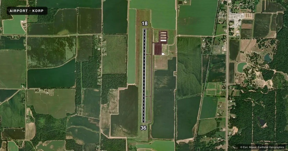
Airport sketch
Runways drawn to scale from FAA survey coordinates, rendered over satellite imagery. Not for navigation.
Approaches & charts
Services on the field
Fuel grades, oxygen, maintenance, ramp storage and lighting — as declared to the FAA by the airport operator.
Fuel & services
- Fuel
- 100LLA
Ramp & ground
- Transient storage
- Tie-down
- Lighting schedule
- SEE RMK
- Beacon schedule
- SS-SR
- Beacon
- White / Green (civil land)(WG)
- Wind indicator
- Lighted
- Segmented circle
- Yes
Fuel & FBOs
Cheapest 100LL and Jet A on the field and nearby. Always confirm with the FBO before taxi.
Airport notes
Surface conditions, obstructions, local procedures, lighting outages and other notes published with each FAA cycle.
General notes
- FOR CD CTC MEMPHIS ARTCC AT 901-368-8453/8449.
Lighting notes
- ACTVT REIL RWYS 18 & 36; HIRL RWY 18/36 - CTAF. PAPI RWYS 18 & 36 OPERS CONTINUOUSLY.
Fuel notes
- 100LLFUEL AVBL SELF SERVE AFT HRS WITH CREDIT CARD (100LL & JET A)
Other notes
- 1FOR SRVC AFT HRS CALL 901-490-5165
VFR map & nearby airports
VFR sectional. Tap any ICAO chip to open that airport.
Key facts · KDRP
Answer card- ICAO
- KDRP
- Name
- DELTA RGNL
- Location
- COLT, ARKANSAS
- Elevation
- 238.8 ft MSL
- Traffic pattern altitude
- 1,238.8 ft MSL (1,000 AGL)
- Control tower
- Non-towered (use CTAF)
- Total runways
- 1
- Longest runway
- 18/36 · 5,003 ft
- Published ILS approaches
- 0
- Published frequencies
- 2
- Magnetic variation
- 1°
- Current flight rules
- VFR
- Current wind
- 000° at 0 kt
- Favored runway now
- –
Delta Rgnl sits in Colt, Arkansas. Field elevation is 238.8 ft MSL. The airport has one runway. Runway 18/36 is 5,003 ft of asphalt, so plan around a single north-south strip with no published ILS approaches. There is no control tower. CTAF and UNICOM are both 123.0.
Pattern altitude is not published. For light piston work, use the standard 1,000 ft AGL unless the current Chart Supplement says otherwise. That puts the pattern at about 1,239 ft MSL based on the field elevation. Runway end identifier lights are active on 18 and 36. High intensity runway lights are on 18/36 and are controlled by CTAF. Precision approach path indicators on both ends operate continuously.
No on-field FBOs are listed. Fuel is available self-serve after hours with credit card for 100LL and Jet A. For clearance delivery, contact Memphis ARTCC at 901-368-8453 or 901-368-8449. If you need service after hours, call 901-490-5165. First-time arrivals should verify the current Chart Supplement before departure, especially if they need IFR planning, lighting details, or any local operating notes.