METAR & TAF M36
M36 does not publish a METAR.
Showing the nearest reporting station: KDRP (DELTA RGNL) · 22.4 NM away. Conditions at M36 may differ.
METAR · KDRP
Observed 12:15Z
KDRP 271215Z AUTO 00000KT 10SM FEW120 27/26 A2995 RMK AO2
- Wind
- 000° @ 0 kt
- Visibility
- 10 SM
- Temp / Dew
- 27°C / 26°C
- Altimeter
- 29.95 inHg
- Clouds
- FEW
- Density alt
- 1,645 ft
- Ceiling
- Unlimited
- Rules
- VFR
Airport info & contacts
Manager on record, flight service, ARTCC, attendance schedule and pattern altitude — published by the FAA and refreshed every 28 days.
Location
- From city
- 0 NM SE
- VFR sectional
- MEMPHIS
- ARTCC
- ZME · MEMPHIS
- NOTAM facility
- JBR (NOTAM-D)
Airport manager
- Name
- KAREN GIFFORD
- Phone
- 870-734-6066
- Address
- 233 WEST CEDAR, BRINKLEY AR 72021
Flight service · Hours
- FSS JBR
- JONESBORO1-800-WX-BRIEF
- Attendance
- MAR-SEP · MON-SAT · 0800-1200
- OCT-FEB · MON-FRI · DAYLIGHT
Frequencies
Tap any row to copy the frequency to your clipboard.
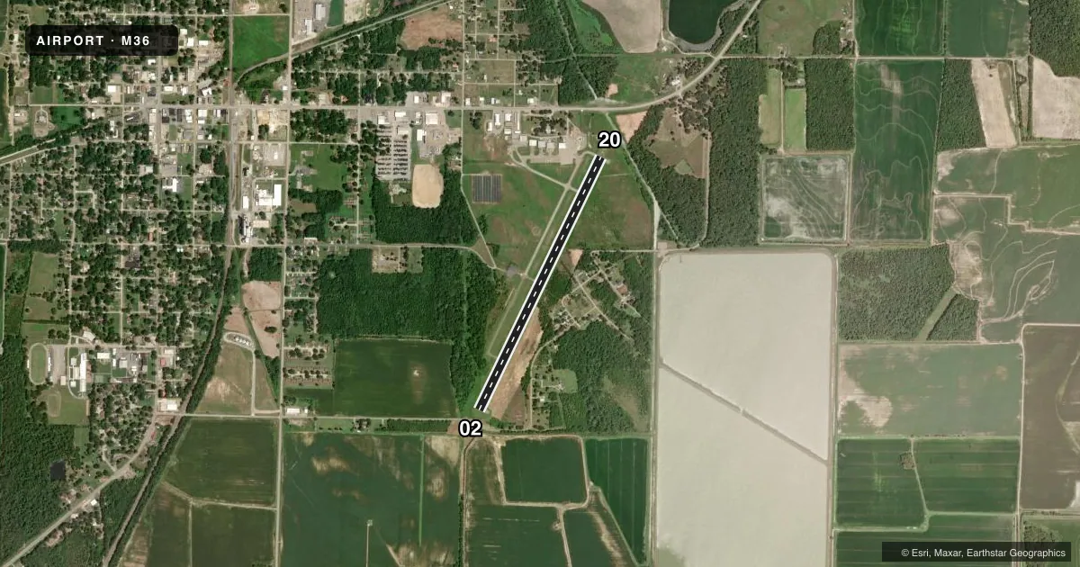
Runways & pattern
Full pagePattern entry · RWY 02
RIGHT TRAFFICRunway end performance
| End | TORA | TODA | ASDA | LDA | VGSI | Approach lights | Obstruction |
|---|---|---|---|---|---|---|---|
| 02 | — | — | — | — | PAPI 2-box left(3°) | — | 25', pole, 525' from thr, 200' R of cntrln, slope 13 |
| 20 | — | — | — | — | PAPI 2-box left(3°) | — | 50', tree, 1250' from thr, 130' R of cntrln, slope 21 |
Declared distances in feet. TORA = takeoff run available, TODA = takeoff distance, ASDA = accelerate-stop, LDA = landing distance.
Airport sketch
Runways drawn to scale from FAA survey coordinates, rendered over satellite imagery. Not for navigation.
Approaches & charts
Services on the field
Fuel grades, oxygen, maintenance, ramp storage and lighting — as declared to the FAA by the airport operator.
Fuel & services
- Fuel
- 100LL
- Airframe repair
- Major
- Power plant repair
- Major
- Other services
- AGRI
Ramp & ground
- Transient storage
- Tie-down
- Hangar
- Landing fee
- No fee published
- Customs
- Not available
- Lighting schedule
- SEE RMK
- Beacon schedule
- SS-SR
- Beacon
- White / Green (civil land)(WG)
- Wind indicator
- Lighted
- Segmented circle
- Yes
Fuel & FBOs
Cheapest 100LL and Jet A on the field and nearby. Always confirm with the FBO before taxi.
Airport notes
Surface conditions, obstructions, local procedures, lighting outages and other notes published with each FAA cycle.
General notes
- WATER-TANK NW.
- NMRS AGRICULTURAL ACFT OPNS FM FEB-NOV 500 FT AGL AND BLW.
- FOR CD CTC MEMPHIS ARTCC AT 901-368-8453/8449.
- MIGRATORY BIRDS ON & INVOF ARPT.
- DEER ON & INVOF ARPT.
Lighting notes
- ACTVT MIRL RWY 02/20 - CTAF.
Fuel notes
- 100LLFUEL AVBL 24 HRS SELF SVC WITH CREDIT CARD.
Approach & departure obstructions
- 02ROAD & BRIDGE SIGNS AT 180 FT FM THR XNG CNTRLN.
- 02PAPI UNUSBL BYD 5 DEGS LEFT OF CNTRLN.
- 20PAPI UNUSBL BYD 4 DEGS LEFT OF CNTRLN AND BYD 7 DEGS RIGHT OF CNTRLN.
- 02APCH SLOPE 30:1 TO DSPLCD THR.
- 20APCH SLOPE 32:1 TO DSPLCD THR.
VFR map & nearby airports
VFR sectional. Tap any ICAO chip to open that airport.
Key facts · M36
Answer card- ICAO
- M36
- Name
- FRANK FEDERER MEML
- Location
- BRINKLEY, ARKANSAS
- Elevation
- 195.3 ft MSL
- Traffic pattern altitude
- 1,195.3 ft MSL (1,000 AGL)
- Control tower
- Non-towered (use CTAF)
- Total runways
- 1
- Longest runway
- 02/20 · 4,002 ft
- Published ILS approaches
- 0
- Published frequencies
- 2
- Magnetic variation
- 2°
- Current flight rules
- VFR
- Current wind
- 000° at 0 kt
- Favored runway now
- –
Frank Federer Meml Airport (M36) sits in Brinkley, Arkansas. Field elevation is 195.3 ft MSL. The airport has one runway. Runway 02/20 is 4,002 ft of asphalt. There is no control tower. CTAF and UNICOM are both 122.8. No ILS approaches are published here.
The published pattern altitude is not listed, so use the standard 1,000 ft AGL for light piston traffic unless the current Chart Supplement says otherwise. The field has 24-hour self-serve 100LL with credit card. Medium intensity runway lights for 02/20 are activated by CTAF. That helps after dark. It also means you need to know the activation procedure before you get there.
A first-time pilot should pay attention to the published obstructions and traffic mix. The Chart Supplement notes birds and deer in the area. It also notes numerous agricultural aircraft operations from February through November at 500 ft AGL and below. The approach to 02 has road and bridge signs near the threshold area. The approach to 20 has a steeply protected slope to the displaced threshold. The PAPI has limited usable alignment on both ends. Clearance delivery is handled through Memphis ARTCC, not a local tower. Check the current FAA Chart Supplement before departure for any updated operational notes.