METAR & TAF KSGT
Current METAR
Observed 12:56Z
KSGT 271256Z AUTO 24004KT 10SM CLR 28/25 A2997 RMK AO2 SLP147 T02780250 $
- Wind
- 240° @ 4 kt
- Visibility
- 10 SM
- Temp / Dew
- 28°C / 25°C
- Altimeter
- 29.97 inHg
- Clouds
- CLR
- Density alt
- 1,776 ft
- Ceiling
- Unlimited
- Rules
- VFR
Airport info & contacts
Manager on record, flight service, ARTCC, attendance schedule and pattern altitude — published by the FAA and refreshed every 28 days.
Location
- From city
- 7 NM N
- VFR sectional
- MEMPHIS
- ARTCC
- ZME · MEMPHIS
- NOTAM facility
- SGT (NOTAM-D)
Airport manager
- Name
- ANTHONY TIBBETT
- Phone
- 870-673-2960
- Address
- 2000 AIRPORT RD TERMINAL BLD, STUTTGART AR 72160
Flight service · Hours
- FSS JBR
- JONESBORO1-800-WX-BRIEF
- Attendance
- NOV-JAN · 0800-2000
- FEB-OCT · MON-FRI · 0800-1600
Frequencies
Tap any row to copy the frequency to your clipboard.
Runways & pattern
Full pagePattern entry · RWY 27
LEFT TRAFFIC| Runway | Heading (°M) | Length | Surface | Traffic |
|---|---|---|---|---|
| 18/36 | 180° / 0° | 6,015 ft | ASPH | Standard L |
| 09/27Favored | 90° / 270° | 5,002 ft | CONC | Standard L |
Runway end performance
| End | TORA | TODA | ASDA | LDA | VGSI | Approach lights | Obstruction |
|---|---|---|---|---|---|---|---|
| 36 | — | — | — | — | — | MALSF | — |
| 09 | — | — | — | — | PAPI 2-box left(3°) | — | — |
| 27 | — | — | — | — | PAPI 2-box left(3°) | — | — |
Declared distances in feet. TORA = takeoff run available, TODA = takeoff distance, ASDA = accelerate-stop, LDA = landing distance.
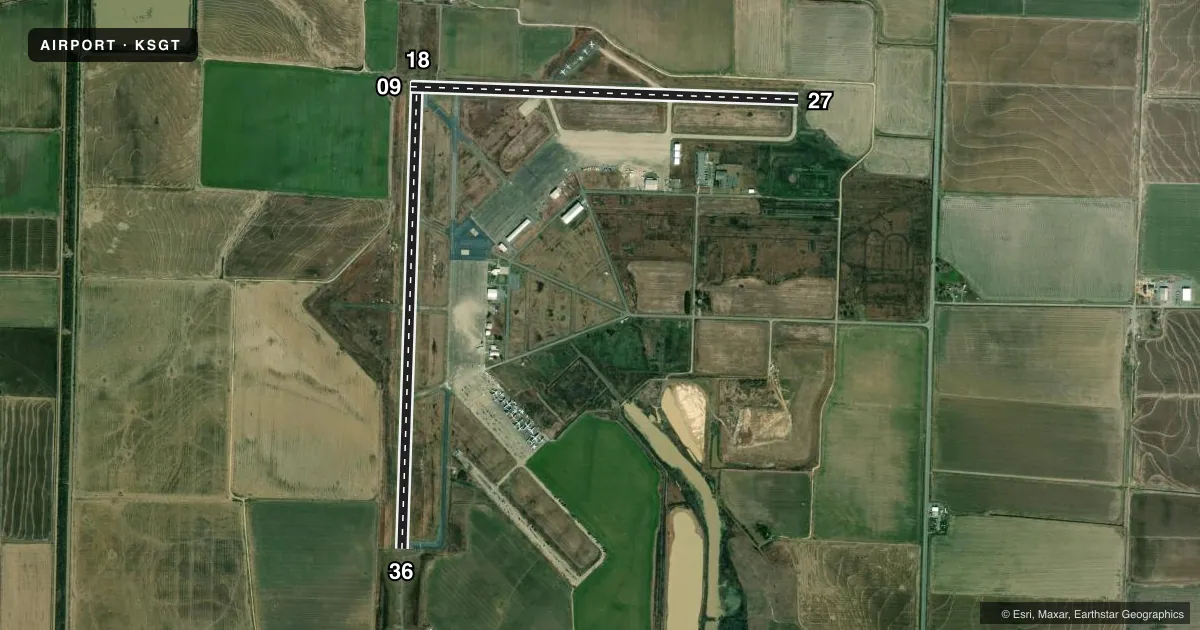
Airport sketch
Runways drawn to scale from FAA survey coordinates, rendered over satellite imagery. Not for navigation.
Approaches & charts
ILS · 1
Services on the field
Fuel grades, oxygen, maintenance, ramp storage and lighting — as declared to the FAA by the airport operator.
Fuel & services
- Fuel
- 100LLA
- Oxygen (bulk)
- Not available
- Airframe repair
- Not available
- Power plant repair
- Not available
- Other services
- AGRI
Ramp & ground
- Transient storage
- Tie-down
- Landing fee
- No fee published
- Customs
- Not available
- Lighting schedule
- SEE RMK
- Beacon schedule
- SS-SR
- Beacon
- White / Green (civil land)(WG)
- Wind indicator
- Yes
- Segmented circle
- Yes
Fuel & FBOs
Cheapest 100LL and Jet A on the field and nearby. Always confirm with the FBO before taxi.
Airport notes
Surface conditions, obstructions, local procedures, lighting outages and other notes published with each FAA cycle.
General notes
- MIGRATORY BIRDS ON & INVOF ARPT NOV-FEB.
- NMRS AGRICULTURAL ACFT OPNS FM FEB-SEP 500 FT AGL AND BLW.
- FOR CD WHEN UNA VIA FREQ CTC LITTLE ROCK APCH 501-379-2908 OR LITTLE ROCK ATCT 501-379-2911
- FOR SVC AFT HRS CALL 870-672-2005.
Lighting notes
- ACTVT MALSF RWY 36; REIL RWY 18 & 27; PAPI RWY 09 & 27; MIRL RWYS 09/27 & 18/36 - CTAF.
Fuel notes
- 100LL100LL AVBL 24 HRS SELF-SERVE WITH CREDIT CARD. FOR FUEL NGTS CALL 870-672-2005.
Approach & departure obstructions
- 09RWY NR FADED.
- 27RWY NR FADED.
Other notes
- MANAGERAIRPORTMANAGER@STUTTGARTAR.COM
VFR map & nearby airports
VFR sectional. Tap any ICAO chip to open that airport.
Key facts · KSGT
Answer card- ICAO
- KSGT
- Name
- STUTTGART MUNI CARL HUMPHREY FLD
- Location
- STUTTGART, ARKANSAS
- Elevation
- 224.4 ft MSL
- Traffic pattern altitude
- 1,224.4 ft MSL (1,000 AGL)
- Control tower
- Non-towered (use CTAF)
- Total runways
- 2
- Longest runway
- 18/36 · 6,015 ft
- Published ILS approaches
- 1
- Published frequencies
- 5
- Magnetic variation
- 2°
- Current flight rules
- VFR
- Current wind
- 240° at 4 kt
- Favored runway now
- RWY 27
Stuttgart Muni Carl Humphrey Fld (KSGT) sits in Stuttgart, Arkansas. Field elevation is 224.4 ft MSL. The airport has two runways. The longest is 18/36 at 6,015 ft. Runway 09/27 is 5,002 ft. There is no control tower, so use CTAF 122.8 for local traffic calls. The published pattern altitude is not listed in the facts. Use the standard 1,000 ft AGL pattern unless current local guidance says otherwise.
KSGT has one ILS approach to runway 36. That matters if the weather starts to come down. The runway lighting setup is useful at night. MALSR is activated on runway 36. Runway end identifier lights are on runways 18 and 27. Medium intensity runway lights are on both runways. The airport also notes that runway numbers are faded on 09 and 27, so confirm the runway before you line up.
Stuttgart Municipal Airport is the on-field FBO. It carries 100LL and Jet A Prist. 100LL is available 24 hours self-serve with credit card. For fuel at night, call the number in the remarks. First-time visitors should also plan for bird activity from November through February. Agricultural aircraft operations are common from February through September at 500 ft AGL and below. That makes vigilance on departure and arrival important.