METAR & TAF 5M1
5M1 does not publish a METAR.
Showing the nearest reporting station: KSGT (STUTTGART MUNI CARL HUMPHREY FLD) · 24.2 NM away. Conditions at 5M1 may differ.
METAR · KSGT
Observed 15:56Z
KSGT 271556Z AUTO 26005KT 10SM CLR 34/23 A2997 RMK AO2 SLP144 T03390233 $
- Wind
- 260° @ 5 kt
- Visibility
- 10 SM
- Temp / Dew
- 34°C / 23°C
- Altimeter
- 29.97 inHg
- Clouds
- CLR
- Density alt
- 2,452 ft
- Ceiling
- Unlimited
- Rules
- VFR
Airport info & contacts
Manager on record, flight service, ARTCC, attendance schedule and pattern altitude — published by the FAA and refreshed every 28 days.
Location
- From city
- 3 NM SE
- VFR sectional
- MEMPHIS
- ARTCC
- ZME · MEMPHIS
- NOTAM facility
- JBR (NOTAM-D)
Airport manager
- Name
- MATTHEW AUFDERHEIDE
- Phone
- 870-830-3091
- Address
- 821 W. 5TH, DEWITT AR 72042
Flight service · Hours
- FSS JBR
- JONESBORO1-800-WX-BRIEF
- Attendance
- MON-FRI · 0800-1700
- MAR-AUG · SAT · 0700-1200
Frequencies
Tap any row to copy the frequency to your clipboard.
Runways & pattern
Full pagePattern entry · RWY 18
LEFT TRAFFICRunway end performance
| End | TORA | TODA | ASDA | LDA | VGSI | Approach lights | Obstruction |
|---|---|---|---|---|---|---|---|
| 18 | — | — | — | — | PAPI 2-box left(3°) | — | 15', road, 450' from thr, 0' R of cntrln, slope 16 |
| 36 | — | — | — | — | PAPI 2-box left(3°) | — | — |
Declared distances in feet. TORA = takeoff run available, TODA = takeoff distance, ASDA = accelerate-stop, LDA = landing distance.
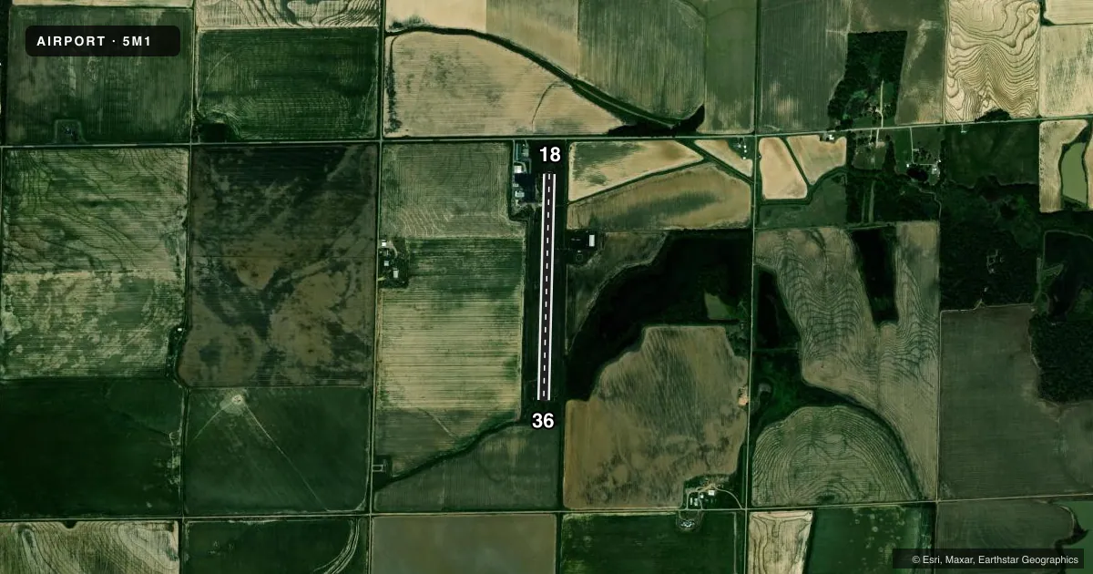
Airport sketch
Runways drawn to scale from FAA survey coordinates, rendered over satellite imagery. Not for navigation.
Approaches & charts
Services on the field
Fuel grades, oxygen, maintenance, ramp storage and lighting — as declared to the FAA by the airport operator.
Fuel & services
- Fuel
- 100LL
- Oxygen (bottled)
- Not available
- Oxygen (bulk)
- Not available
- Airframe repair
- Major
- Power plant repair
- Major
- Other services
- AGRI
Ramp & ground
- Transient storage
- Tie-down
- Landing fee
- No fee published
- Customs
- Not available
- Lighting schedule
- SEE RMK
- Beacon schedule
- SS-SR
- Beacon
- White / Green (civil land)(WG)
- Wind indicator
- Lighted
- Segmented circle
- Yes
Fuel & FBOs
Cheapest 100LL and Jet A on the field and nearby. Always confirm with the FBO before taxi.
Airport notes
Surface conditions, obstructions, local procedures, lighting outages and other notes published with each FAA cycle.
General notes
- FOR CD CTC MEMPHIS ARTCC AT 901-368-8453/8449.
Lighting notes
- ACTVT REIL RWY 18 & 36; PAPI RWY 18 & 36; MIRL RWY 18/36 - CTAF.
Fuel notes
- 100LLFUEL AVBL 24 HR SELF SERVE WITH CREDIT CARD.
Other notes
- 2FOR SVC AFT HRS CALL 870-830-3091 OR 870-946-1745
VFR map & nearby airports
VFR sectional. Tap any ICAO chip to open that airport.
Key facts · 5M1
Answer card- ICAO
- 5M1
- Name
- DEWITT MUNI/WHITCOMB FLD
- Location
- DE WITT, ARKANSAS
- Elevation
- 188.8 ft MSL
- Traffic pattern altitude
- 1,188.8 ft MSL (1,000 AGL)
- Control tower
- Non-towered (use CTAF)
- Total runways
- 1
- Longest runway
- 18/36 · 3,205 ft
- Published ILS approaches
- 0
- Published frequencies
- 1
- Magnetic variation
- 1°
- Current flight rules
- VFR
- Current wind
- 260° at 5 kt
- Favored runway now
- RWY 18
DeWitt Muni/Whitcomb Fld sits in De Witt, Arkansas. Field elevation is 188.8 ft MSL. The airport has one runway. Runway 18/36 is 3,205 ft of asphalt, with magnetic headings of 181° and 1°. There is no control tower, so use CTAF 122.9 for local traffic. No ILS approaches are published here.
Pattern altitude is not published. Use the standard 1,000 ft AGL unless the current Chart Supplement says otherwise. For a light piston, that puts the pattern near 1,189 ft MSL based on field elevation. The field has medium intensity runway lights on 18 and 36. They are CTAF controlled. Runway end identifier lights and PAPI are also installed on both ends, which helps on night arrivals.
DeWitt Municipal Airport is on the field. It carries 100LL. Fuel is available 24 hours self-serve with credit card. If you need service after hours, the published remarks list phone numbers for help. For clearance delivery, contact Memphis ARTCC before departure. This is a non-towered field with a single runway, so plan your arrival, monitor CTAF early and verify current notes in the Chart Supplement before you go.