METAR & TAF 4M8
4M8 does not publish a METAR.
Showing the nearest reporting station: KSGT (STUTTGART MUNI CARL HUMPHREY FLD) · 9.3 NM away. Conditions at 4M8 may differ.
METAR · KSGT
Observed 12:56Z
KSGT 271256Z AUTO 24004KT 10SM CLR 28/25 A2997 RMK AO2 SLP147 T02780250 $
- Wind
- 240° @ 4 kt
- Visibility
- 10 SM
- Temp / Dew
- 28°C / 25°C
- Altimeter
- 29.97 inHg
- Clouds
- CLR
- Density alt
- 1,762 ft
- Ceiling
- Unlimited
- Rules
- VFR
Airport info & contacts
Manager on record, flight service, ARTCC, attendance schedule and pattern altitude — published by the FAA and refreshed every 28 days.
Location
- From city
- 5 NM SW
- VFR sectional
- MEMPHIS
- ARTCC
- ZME · MEMPHIS
- NOTAM facility
- JBR (NOTAM-D)
Airport manager
- Name
- MICHAEL HUTCHINS
- Phone
- 870-241-3781
- Address
- PO BOX 227, ROE AR 72134
Flight service · Hours
- FSS JBR
- JONESBORO1-800-WX-BRIEF
- Attendance
- MON-FRI · 0800-1700
Frequencies
Tap any row to copy the frequency to your clipboard.
Runways & pattern
Full pagePattern entry · RWY 18
LEFT TRAFFICRunway end performance
| End | TORA | TODA | ASDA | LDA | VGSI | Approach lights | Obstruction |
|---|---|---|---|---|---|---|---|
| 18 | — | — | — | — | — | — | 15', road, 300' from thr, 0' R of cntrln, slope 6 |
Declared distances in feet. TORA = takeoff run available, TODA = takeoff distance, ASDA = accelerate-stop, LDA = landing distance.
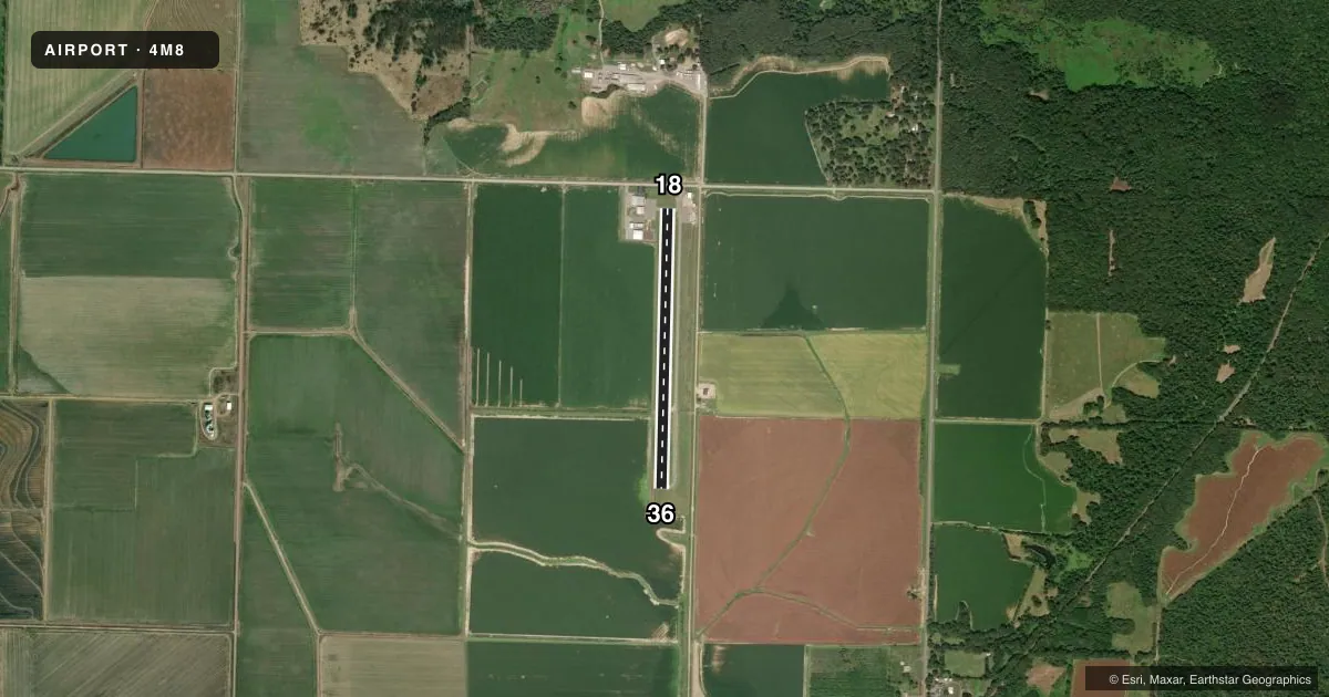
Airport sketch
Runways drawn to scale from FAA survey coordinates, rendered over satellite imagery. Not for navigation.
Approaches & charts
Services on the field
Fuel grades, oxygen, maintenance, ramp storage and lighting — as declared to the FAA by the airport operator.
Fuel & services
- Fuel
- 100LL
- Oxygen (bottled)
- Not available
- Oxygen (bulk)
- Not available
- Airframe repair
- Minor
- Power plant repair
- Minor
- Other services
- AGRI
Ramp & ground
- Transient storage
- Tie-down
- Landing fee
- No fee published
- Customs
- Not available
- Lighting schedule
- SEE RMK
- Beacon schedule
- SS-SR
- Beacon
- White / Green (civil land)(WG)
- Wind indicator
- Yes
- Segmented circle
- No
Fuel & FBOs
Cheapest 100LL and Jet A on the field and nearby. Always confirm with the FBO before taxi.
Airport notes
Surface conditions, obstructions, local procedures, lighting outages and other notes published with each FAA cycle.
General notes
- RY 18/36 AGRICULTURE ACFT USE TURF 2400 FT BY 100 FT AREA EAST SIDE OF PAVED RWY; SOFT WHEN WET.
- MIGRATORY BIRDS INVOF ARPT.
- FOR CD CTC MEMPHIS ARTCC AT 901-368-8453/8449.
Lighting notes
- ACTVT MIRL RWY 18/36 - 122.7.
Fuel notes
- 100LLFUEL AVBL 24 HRS SELF SERVE.
Approach & departure obstructions
- 18MARKINGS FADED.
- 36MARKINGS FADED.
Other notes
- PRE DATES THE ACT.
VFR map & nearby airports
VFR sectional. Tap any ICAO chip to open that airport.
Key facts · 4M8
Answer card- ICAO
- 4M8
- Name
- CLARENDON MUNI
- Location
- CLARENDON, ARKANSAS
- Elevation
- 213.1 ft MSL
- Traffic pattern altitude
- 1,213.1 ft MSL (1,000 AGL)
- Control tower
- Non-towered (use CTAF)
- Total runways
- 1
- Longest runway
- 18/36 · 3,256 ft
- Published ILS approaches
- 0
- Published frequencies
- 2
- Magnetic variation
- 3°
- Current flight rules
- VFR
- Current wind
- 240° at 4 kt
- Favored runway now
- RWY 18
Clarendon Muni sits in Clarendon, Arkansas at 213.1 ft MSL. It has one runway, 18/36, which is 3,256 ft long and paved with asphalt. The airport is non-towered. CTAF and UNICOM are both 122.8. No ILS approaches are published here, so plan with the current chart and weather in mind if you are arriving in lower visibility.
The pattern altitude is not published. For light piston work, use the standard 1,000 ft AGL unless the current Chart Supplement or local procedures say otherwise. Runway 18 and runway 36 both have faded markings. The runway lights on 18/36 are medium intensity and are activated on 122.7. Fuel is available 24 hours self-serve for 100LL.
There is no on-field FBO listed. A turf area for agriculture aircraft sits on the east side of the paved runway. It is 2,400 ft by 100 ft and can be soft when wet. Migratory birds are reported in the area, so keep a sharp scan on climbout and final. For clearance delivery, contact Memphis ARTCC at 901-368-8453 or 901-368-8449.