METAR & TAF 2A6
2A6 does not publish a METAR.
Showing the nearest reporting station: KSGT (STUTTGART MUNI CARL HUMPHREY FLD) · 20.3 NM away. Conditions at 2A6 may differ.
METAR · KSGT
Observed 15:56Z
KSGT 271556Z AUTO 26005KT 10SM CLR 34/23 A2997 RMK AO2 SLP144 T03390233 $
- Wind
- 260° @ 5 kt
- Visibility
- 10 SM
- Temp / Dew
- 34°C / 23°C
- Altimeter
- 29.97 inHg
- Clouds
- CLR
- Density alt
- 2,436 ft
- Ceiling
- Unlimited
- Rules
- VFR
Airport info & contacts
Manager on record, flight service, ARTCC, attendance schedule and pattern altitude — published by the FAA and refreshed every 28 days.
Location
- From city
- 1 NM SE
- VFR sectional
- MEMPHIS
- ARTCC
- ZME · MEMPHIS
- NOTAM facility
- JBR (NOTAM-D)
Airport manager
- Name
- MIKE RICHARDSON
- Phone
- 870-462-3675
- Address
- P.O. BOX 344, HOLLY GROVE AR 72069
Flight service · Hours
- FSS JBR
- JONESBORO1-800-WX-BRIEF
- Attendance
- MON-SAT · 0800-1700
Frequencies
Tap any row to copy the frequency to your clipboard.
Runways & pattern
Full pagePattern entry · RWY 33
LEFT TRAFFICRunway end performance
| End | TORA | TODA | ASDA | LDA | VGSI | Approach lights | Obstruction |
|---|---|---|---|---|---|---|---|
| 15 | — | — | — | — | TRIL(3°) | — | 25', tree, 750' from thr, 200' R of cntrln, slope 22 |
| 33 | — | — | — | — | TRIL(3°) | — | 10', fence, 201' from thr, 0' R of cntrln, slope 0 |
Declared distances in feet. TORA = takeoff run available, TODA = takeoff distance, ASDA = accelerate-stop, LDA = landing distance.
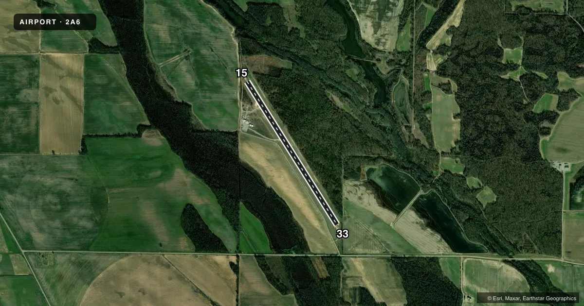
Airport sketch
Runways drawn to scale from FAA survey coordinates, rendered over satellite imagery. Not for navigation.
Approaches & charts
Services on the field
Fuel grades, oxygen, maintenance, ramp storage and lighting — as declared to the FAA by the airport operator.
Fuel & services
- Fuel
- Not available
- Other services
- AGRI
Ramp & ground
- Transient storage
- Tie-down
- Lighting schedule
- SEE RMK
- Beacon schedule
- SS-SR
- Beacon
- White / Green (civil land)(WG)
- Wind indicator
- Lighted
- Segmented circle
- No
Fuel & FBOs
Cheapest 100LL and Jet A on the field and nearby. Always confirm with the FBO before taxi.
Airport notes
Surface conditions, obstructions, local procedures, lighting outages and other notes published with each FAA cycle.
General notes
- DEER ON & INVOF ARPT.
- FOR CD CTC MEMPHIS ARTCC AT 901-368-8453/8449.
Lighting notes
- BCN OTS INDEFLY
- ACTVT MIRL RY 15/33, VASI RYS 15 & 33 - CTAF.
Approach & departure obstructions
- 3310 FT FENCE 150 FT CROSSING RY EXTENDING INTO RPZ.
- 15TRIL OTS INDEFLY
Other notes
- 1FOR ATTENDANT AFT HRS CALL 870-672-1807.
VFR map & nearby airports
VFR sectional. Tap any ICAO chip to open that airport.
Key facts · 2A6
Answer card- ICAO
- 2A6
- Name
- HOLLY GROVE MUNI
- Location
- HOLLY GROVE, ARKANSAS
- Elevation
- 176 ft MSL
- Traffic pattern altitude
- 1,176 ft MSL (1,000 AGL)
- Control tower
- Non-towered (use CTAF)
- Total runways
- 1
- Longest runway
- 15/33 · 4,469 ft
- Published ILS approaches
- 0
- Published frequencies
- 1
- Magnetic variation
- 3°
- Current flight rules
- VFR
- Current wind
- 260° at 5 kt
- Favored runway now
- RWY 33
HOLLY GROVE MUNI sits in Holly Grove, Arkansas. Field elevation is 176 ft MSL. The airport has one runway, 15/33, which is 4,469 ft long and asphalt. There is no control tower. CTAF is 122.9. No ILS approaches are published here.
Pattern altitude is not published. Use the standard 1,000 ft AGL pattern for light piston operations unless the current Chart Supplement says otherwise. The published remarks matter here. The tri-color VASI on runway 15 is out of service indefinitely. The airport beacon is also out of service indefinitely. Medium intensity runway lights are available on 15/33. Visual approach slope indicators are on both runway ends and are controlled by CTAF.
Plan for local hazards. Deer are reported on and near the airport. There is also a 10-foot fence crossing the runway extension and extending into the runway protection zone at runway 33. For clearance delivery, contact Memphis ARTCC at 901-368-8453 or 901-368-8449. There are no on-field FBOs listed, so verify services with the airport operator or call ahead before arrival. If you need after-hours attendant help, the published remark gives a phone number to use.