METAR & TAF 6M7
6M7 does not publish a METAR.
Showing the nearest reporting station: KDRP (DELTA RGNL) · 20.3 NM away. Conditions at 6M7 may differ.
METAR · KDRP
Observed 11:55Z
KDRP 271155Z AUTO 20008KT 10SM SCT060 SCT120 26/25 A3001 RMK AO2
- Wind
- 200° @ 8 kt
- Visibility
- 10 SM
- Temp / Dew
- 26°C / 25°C
- Altimeter
- 30.01 inHg
- Clouds
- SCT
- Density alt
- 1,480 ft
- Ceiling
- Unlimited
- Rules
- VFR
Airport info & contacts
Manager on record, flight service, ARTCC, attendance schedule and pattern altitude — published by the FAA and refreshed every 28 days.
Location
- From city
- 3 NM W
- VFR sectional
- MEMPHIS
- ARTCC
- ZME · MEMPHIS
- NOTAM facility
- JBR (NOTAM-D)
Airport manager
- Name
- DOUG GIBSON
- Phone
- 870-295-3485
- Address
- BOX 478, MARIANNA AR 72360
Flight service · Hours
- FSS JBR
- JONESBORO1-800-WX-BRIEF
- Attendance
- MON-FRI · DALGT
Frequencies
Tap any row to copy the frequency to your clipboard.
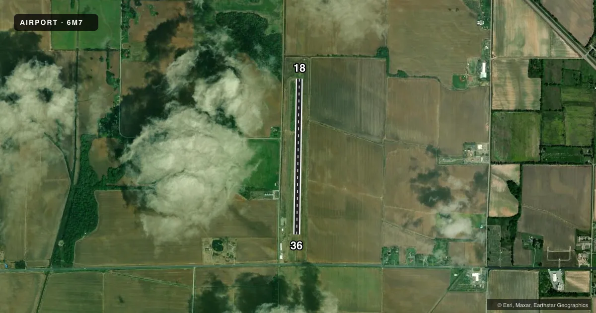
Runways & pattern
Full pagePattern entry · RWY 18
LEFT TRAFFICRunway end performance
| End | TORA | TODA | ASDA | LDA | VGSI | Approach lights | Obstruction |
|---|---|---|---|---|---|---|---|
| 18 | — | — | — | — | PAPI 2-box left(3°) | — | 75', tree, 825' from thr, 500' R of cntrln, slope 8 |
| 36 | — | — | — | — | PAPI 2-box left(3°) | — | 30', tree, 1250' from thr, 525' R of cntrln, slope 35 |
Declared distances in feet. TORA = takeoff run available, TODA = takeoff distance, ASDA = accelerate-stop, LDA = landing distance.
Airport sketch
Runways drawn to scale from FAA survey coordinates, rendered over satellite imagery. Not for navigation.
Approaches & charts
Services on the field
Fuel grades, oxygen, maintenance, ramp storage and lighting — as declared to the FAA by the airport operator.
Fuel & services
- Fuel
- 100LL
- Oxygen (bottled)
- Not available
- Oxygen (bulk)
- Not available
- Other services
- AGRI
Ramp & ground
- Transient storage
- Tie-down
- Landing fee
- No fee published
- Lighting schedule
- SEE RMK
- Beacon schedule
- SS-SR
- Beacon
- White / Green (civil land)(WG)
- Wind indicator
- Lighted
- Segmented circle
- Yes
Fuel & FBOs
Cheapest 100LL and Jet A on the field and nearby. Always confirm with the FBO before taxi.
Airport notes
Surface conditions, obstructions, local procedures, lighting outages and other notes published with each FAA cycle.
General notes
- RWY 36 75 FT UNLGTD PLINE 2300 FT SOUTH OF THR.
- NMRS AGRICULTURE OPS FEB-OCT.
- FOR CD CTC MEMPHIS ARTCC AT 901-368-8453/8449.
Lighting notes
- ACTVT REIL RWY 18 & 36; PAPI RWY 18 & 36; MIRL RWY 18/36 - CTAF.
Fuel notes
- 100LLFOR FUEL AFT HRS CALL 870-295-3485.
Approach & departure obstructions
- 18MRKGS RWY 18 FADED.
- 36MRKGS RWY 36 FADED.
VFR map & nearby airports
VFR sectional. Tap any ICAO chip to open that airport.
Key facts · 6M7
Answer card- ICAO
- 6M7
- Name
- MARIANNA/LEE COUNTY-STEVE EDWARDS FLD
- Location
- MARIANNA, ARKANSAS
- Elevation
- 219.1 ft MSL
- Traffic pattern altitude
- 1,219.1 ft MSL (1,000 AGL)
- Control tower
- Non-towered (use CTAF)
- Total runways
- 1
- Longest runway
- 18/36 · 4,021 ft
- Published ILS approaches
- 0
- Published frequencies
- 2
- Magnetic variation
- 0°
- Current flight rules
- VFR
- Current wind
- 200° at 8 kt
- Favored runway now
- RWY 18
Marianna/Lee County-Steve Edwards Fld (6M7) sits in Marianna, Arkansas. Field elevation is 219.1 ft MSL. The airport has one runway, 18/36, which is 4,021 ft long and paved. There is no control tower. CTAF and UNICOM are both 122.8. No ILS approaches are published here.
Pattern altitude is not published. Use standard 1,000 ft AGL for light piston operations unless the current Chart Supplement says otherwise. Runway 18 and runway 36 both have faded markings, so plan for a careful visual check on rollout and lineup. Runway end identifier lights are active on both ends. PAPI is installed on both runway ends. Medium intensity runway lights are installed on 18/36.
No on-field FBOs are listed. For fuel after hours, the published remarks say to call 870-295-3485. Numerous agriculture operations occur from February through October, so expect low-level traffic and keep a sharp lookout in season. Runway 36 also has a 75-foot unlighted power line 2,300 ft south of the threshold. For clearance delivery, contact Memphis ARTCC at 901-368-8453 or 901-368-8449. If you are planning a night arrival or a busy ag season arrival, verify the current Chart Supplement and coordinate early.