METAR & TAF KUTA
Current METAR
Observed 15:15Z
KUTA 271515Z AUTO VRB03KT 10SM CLR 32/27 A2995 RMK AO2 T03210270 $
- Wind
- VAR @ 3 kt
- Visibility
- 10 SM
- Temp / Dew
- 32°C / 27°C
- Altimeter
- 29.95 inHg
- Clouds
- CLR
- Density alt
- 2,244 ft
- Ceiling
- Unlimited
- Rules
- VFR
Airport info & contacts
Manager on record, flight service, ARTCC, attendance schedule and pattern altitude — published by the FAA and refreshed every 28 days.
Location
- From city
- 1 NM E
- VFR sectional
- MEMPHIS
- ARTCC
- ZME · MEMPHIS
- NOTAM facility
- UTA (NOTAM-D)
Airport manager
- Name
- MARIE WARNER
- Phone
- 662-357-7320
- Address
- 209 S ARPT BLVD-PO BOX 158, TUNICA MS 38676
Flight service · Hours
- FSS GWO
- GREENWOOD1-800-WX-BRIEF
- Attendance
- 0600-2100
Frequencies
Tap any row to copy the frequency to your clipboard.
Runways & pattern
Full pagePattern entry · RWY 35
RIGHT TRAFFICRunway end performance
| End | TORA | TODA | ASDA | LDA | VGSI | Approach lights | Obstruction |
|---|---|---|---|---|---|---|---|
| 17 | — | — | — | — | PAPI 4-box left(3°) | — | — |
| 35 | — | — | — | — | PAPI 4-box left(3°) | MALSR | — |
Declared distances in feet. TORA = takeoff run available, TODA = takeoff distance, ASDA = accelerate-stop, LDA = landing distance.
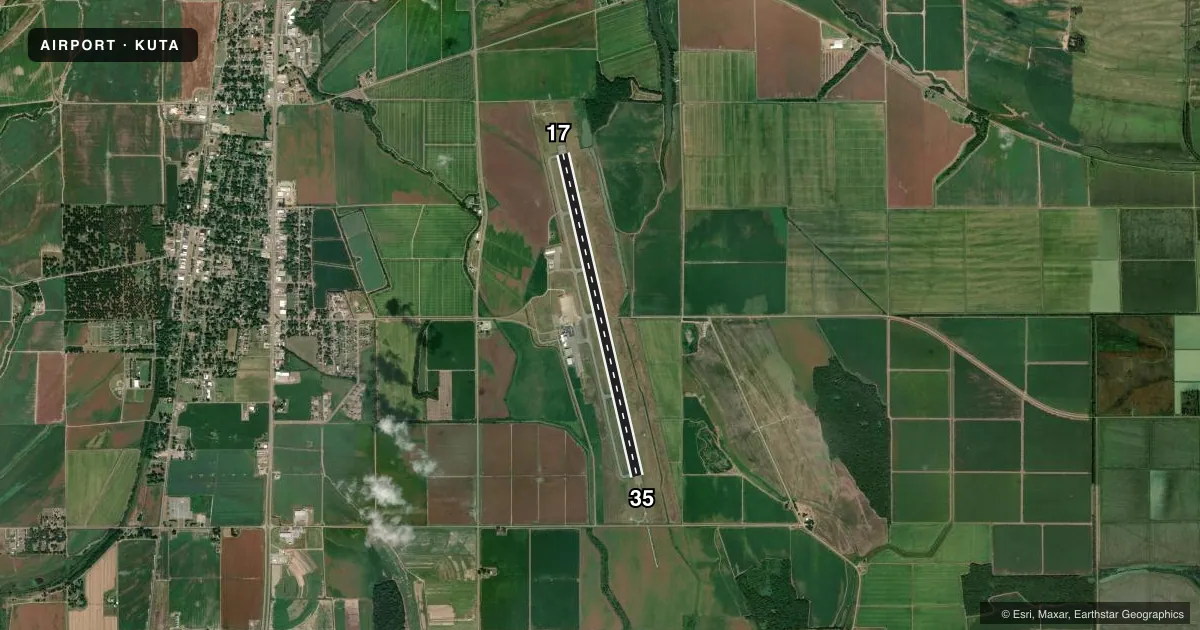
Airport sketch
Runways drawn to scale from FAA survey coordinates, rendered over satellite imagery. Not for navigation.
Approaches & charts
ILS · 1
Services on the field
Fuel grades, oxygen, maintenance, ramp storage and lighting — as declared to the FAA by the airport operator.
Fuel & services
- Fuel
- 100LLA
- Oxygen (bottled)
- High pressure
- Oxygen (bulk)
- High pressure
- Airframe repair
- Major
- Power plant repair
- Major
- Other services
- AGRI
Ramp & ground
- Transient storage
- Tie-down
- Hangar
- Landing fee
- No fee published
- Lighting schedule
- SEE RMK
- Beacon schedule
- SS-SR
- Beacon
- White / Green (civil land)(WG)
- Wind indicator
- Lighted
- Segmented circle
- Yes
Fuel & FBOs
Cheapest 100LL and Jet A on the field and nearby. Always confirm with the FBO before taxi.
Airport notes
Surface conditions, obstructions, local procedures, lighting outages and other notes published with each FAA cycle.
General notes
- AGRICULTURAL ACT INVOF ARPT DALGT.
- GEESE INVOF ARPT NOV - FEB.
- 24 HR PPR COML FLT OVR 30 PAX - AMGR.
- FOR CD CTC MEMPHIS APCH AT 901-842-8457.
Lighting notes
- ACTVT MALSR RWY 35; REIL RWY 17; HIRL RWY 17/35 - CTAF.
Runway surface & condition
- 17/35TRIPLE TANDEM = 510
- 17/35RWY 35 CALM WIND RWY.
Other notes
- VFR ONLY; ARPT TFC PATTERN ESTABLISHED ON EAST SIDE OF RWY AND RWY CNTRLN EXTNDD.
- CLSD TO SKED ACR OPS WITH MORE THAN 9 PAX SEATS & UNSKED ACR OPS WITH MORE THAN 30 PAX SEATS.
- 1AFT HR FUEL - AMGR.
VFR map & nearby airports
VFR sectional. Tap any ICAO chip to open that airport.
Key facts · KUTA
Answer card- ICAO
- KUTA
- Name
- TUNICA MUNI
- Location
- TUNICA, MISSISSIPPI
- Elevation
- 194.4 ft MSL
- Traffic pattern altitude
- 1,194.4 ft MSL (1,000 AGL)
- Control tower
- Non-towered (use CTAF)
- Total runways
- 1
- Longest runway
- 17/35 · 8,500 ft
- Published ILS approaches
- 1
- Published frequencies
- 5
- Magnetic variation
- 0°
- Current flight rules
- VFR
- Current wind
- 000° at 3 kt
- Favored runway now
- RWY 35
Tunica Muni sits in Tunica, Mississippi. Field elevation is 194.4 ft MSL. The airport has one runway, 17/35 and it is 8,500 ft long. There is no control tower. The published pattern altitude is not listed, so plan on the standard 1,000 ft AGL for light piston traffic unless ATC or the airport operator tells you otherwise.
Runway 35 has the ILS approach. The field is VFR only per the published remarks. Traffic pattern is on the east side of the runway. Runway 35 is the calm wind runway. High intensity runway lights are installed on both ends. The approach lighting system with runway alignment lights is on runway 35. Runway end identifier lights are on runway 17.
Tunica Air Center is on the field. It carries 100LL, Jet A and Jet A Prist. After-hours fuel is available from the airport manager. For clearance delivery, contact Memphis Approach at 901-842-8457. Geese are reported in the area from November through February. Agricultural activity also occurs nearby in daylight. This is a field where a first-time pilot should brief the VFR-only note. Brief the east-side pattern. Brief the runway 35 lighting setup before arrival.