METAR & TAF KNQA
Current METAR
Observed 07:55Z
KNQA 270755Z AUTO 24004KT 9SM FEW050 27/26 A2989 RMK A01
- Wind
- 240° @ 4 kt
- Visibility
- 9 SM
- Temp / Dew
- 27°C / 26°C
- Altimeter
- 29.89 inHg
- Clouds
- FEW
- Density alt
- 1,877 ft
- Ceiling
- Unlimited
- Rules
- VFR
Airport info & contacts
Manager on record, flight service, ARTCC, attendance schedule and pattern altitude — published by the FAA and refreshed every 28 days.
Location
- From city
- 1 NM NE
- VFR sectional
- MEMPHIS
- ARTCC
- ZME · MEMPHIS
- NOTAM facility
- NQA (NOTAM-D)
Airport manager
- Name
- MR. MIKE GILL
- Phone
- 901-872-7495
- Address
- 8182 HORNET AVE, MILLINGTON TN 38053
Flight service · Hours
- FSS MKL
- JACKSON1-800-WX-BRIEF
- Attendance
- MON-FRI · 0730-0200
- SAT-SUN · 0700-1900
Frequencies
Tap any row to copy the frequency to your clipboard.
Runways & pattern
Full pagePattern entry · RWY 22
RIGHT TRAFFICRunway end performance
| End | TORA | TODA | ASDA | LDA | VGSI | Approach lights | Obstruction |
|---|---|---|---|---|---|---|---|
| 04 | — | — | — | — | PAPI 4-box left(3°) | — | — |
| 22 | — | — | — | — | PAPI 4-box left(3°) | MALSR | — |
Declared distances in feet. TORA = takeoff run available, TODA = takeoff distance, ASDA = accelerate-stop, LDA = landing distance.
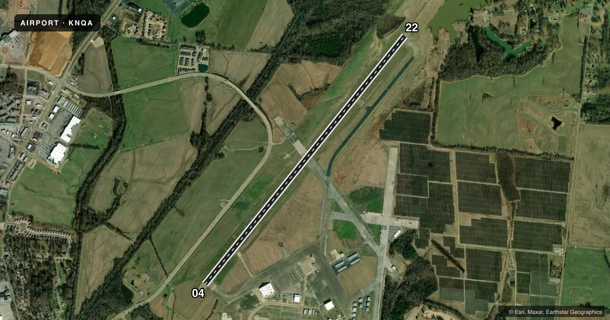
Airport sketch
Runways drawn to scale from FAA survey coordinates, rendered over satellite imagery. Not for navigation.
Approaches & charts
ILS · 1
Services on the field
Fuel grades, oxygen, maintenance, ramp storage and lighting — as declared to the FAA by the airport operator.
Fuel & services
- Fuel
- 100LLA+
- Oxygen (bottled)
- Low pressure
- Airframe repair
- Major
- Power plant repair
- Major
- Other services
- AVNCS
Ramp & ground
- Transient storage
- Tie-down
- Hangar
- Lighting schedule
- SEE RMK
- Beacon schedule
- SS-SR
- Beacon
- White / Green (civil land)(WG)
- Wind indicator
- Lighted
- Segmented circle
- Yes
Fuel & FBOs
Cheapest 100LL and Jet A on the field and nearby. Always confirm with the FBO before taxi.
Airport notes
Surface conditions, obstructions, local procedures, lighting outages and other notes published with each FAA cycle.
General notes
- CAT C AFLD.
- TWY B CLSD TO ACR.
- FOR CD WHEN ATCT IS CLSD CTC MEM APCH AT 901-842-8457.
Lighting notes
- ACTVT MALSR RWY 22; REIL RWY 04; HIRL RWY 04/22 - CTAF. HIRL RWY 04/22 PRESET LOW INTST; INCR INTST - CTAF. PAPI RWY 04 & 22 ON CONSLY.
Fuel notes
- 100LLJASU AVBL.
Runway surface & condition
- 04/22PCR VALUE: 1038/F/C/X/T
Other notes
- ARPT CLSD TO UNSKED ACR OPS WITH MORE THAN 30 PAX SEATS. ARFF NOT AVBL MON 1130-0300Z; TUE-SAT 0800-1130Z; SAT-SUN 2000-1130Z EXC PPR. INDEX D ARFF AVBL PPR - 901-873-5792.
- 1SVC AFT HR - 901-873-4359.
VFR map & nearby airports
VFR sectional. Tap any ICAO chip to open that airport.
Key facts · KNQA
Answer card- ICAO
- KNQA
- Name
- MILLINGTON/MEMPHIS
- Location
- MILLINGTON, TENNESSEE
- Elevation
- 322.4 ft MSL
- Traffic pattern altitude
- 1,322.4 ft MSL (1,000 AGL)
- Control tower
- Towered · 0900-0200 MON; 0530-0200 TUE-FRI; 0530-1900 SAT-SUN
- Total runways
- 1
- Longest runway
- 04/22 · 8,001 ft
- Published ILS approaches
- 1
- Published frequencies
- 21
- Magnetic variation
- 0°
- Current flight rules
- VFR
- Current wind
- 240° at 4 kt
- Favored runway now
- RWY 22
KNQA is in Millington, Tennessee, near Memphis. Field elevation is 322.4 ft MSL. The airport has one runway, 04/22, which is 8,001 ft long. The tower is open 0900-0200 Monday, 0530-0200 Tuesday through Friday and 0530-1900 Saturday and Sunday. One ILS is published for runway 22.
Pattern altitude is not published. Use the standard 1,000 ft AGL for light piston traffic unless the current Chart Supplement says otherwise. The airport is a category C airfield. Magnetic variation is 0°, so the runway numbers match the magnetic headings closely. Taxiway B is closed to aircraft. Plan your taxi carefully.
Millington/Memphis Airport has one on-field FBO. Millington/Memphis Airport carries 100LL and Jet A. The airport also has runway lighting details that matter at night. MALSR is on runway 22. Runway end identifier lights are on runway 04. High intensity runway lights are on both ends and are controlled on CTAF. They are preset to low intensity. They can be increased on CTAF. PAPI is on both runway ends and is on continuously.
For tower-closed departures, clearance delivery goes through Memphis Approach. The field also has restrictions tied to unscheduled aircraft operations with more than 30 passenger seats. Check the current Chart Supplement and call the airport operator if that applies to your flight.