METAR & TAF KFYE
Current METAR
Observed 04:15Z
KFYE 270415Z AUTO 00000KT 9SM CLR 28/27 A2993 RMK A01
- Wind
- 000° @ 0 kt
- Visibility
- 9 SM
- Temp / Dew
- 28°C / 27°C
- Altimeter
- 29.93 inHg
- Clouds
- CLR
- Density alt
- 2,088 ft
- Ceiling
- Unlimited
- Rules
- VFR
Airport info & contacts
Manager on record, flight service, ARTCC, attendance schedule and pattern altitude — published by the FAA and refreshed every 28 days.
Location
- From city
- 2 NM SW
- VFR sectional
- MEMPHIS
- ARTCC
- ZME · MEMPHIS
- NOTAM facility
- MKL (NOTAM-D)
Airport manager
- Name
- RUSTY BLISS
- Phone
- 901-466-7007
- Address
- 1075 AIRPORT ROAD, SOMERVILLE TN 38068
Flight service · Hours
- FSS MKL
- JACKSON1-800-WX-BRIEF
- Attendance
- MON-SAT · 0800-1800
- MAY-SEPT · SUN · 1300-1800
- OCT-APR · SUN · 1300-1700
Frequencies
Tap any row to copy the frequency to your clipboard.
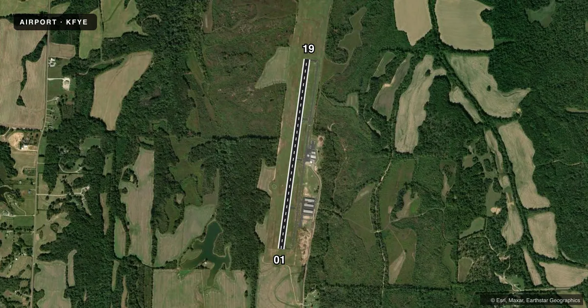
Runways & pattern
Full pagePattern entry · RWY 01
LEFT TRAFFICRunway end performance
| End | TORA | TODA | ASDA | LDA | VGSI | Approach lights | Obstruction |
|---|---|---|---|---|---|---|---|
| 01 | — | — | — | — | PAPI 2-box left(3°) | — | 77', tree, 2127' from thr, 515' R of cntrln, slope 25 |
| 19 | — | — | — | — | PAPI 2-box left(3.07°) | — | 86', tree, 3118' from thr, 196' R of cntrln, slope 33 |
Declared distances in feet. TORA = takeoff run available, TODA = takeoff distance, ASDA = accelerate-stop, LDA = landing distance.
Airport sketch
Runways drawn to scale from FAA survey coordinates, rendered over satellite imagery. Not for navigation.
Approaches & charts
Services on the field
Fuel grades, oxygen, maintenance, ramp storage and lighting — as declared to the FAA by the airport operator.
Fuel & services
- Fuel
- 100LLA
- Other services
- AGRI,INSTR
Ramp & ground
- Transient storage
- Tie-down
- Hangar
- Lighting schedule
- SS-SR
- Beacon schedule
- SS-SR
- Beacon
- White / Green (civil land)(WG)
- Wind indicator
- Lighted
- Segmented circle
- Yes
Fuel & FBOs
Cheapest 100LL and Jet A on the field and nearby. Always confirm with the FBO before taxi.
Airport notes
Surface conditions, obstructions, local procedures, lighting outages and other notes published with each FAA cycle.
General notes
- DEER INVOF MOV AREAS.
- FOR CD CTC MEMPHIS APCH AT 901-842-8457.
Other notes
- O/R - AMGR.
- VFR ONLY.
- O/R - AMGR.
- MANAGER901-212-4393
VFR map & nearby airports
VFR sectional. Tap any ICAO chip to open that airport.
Key facts · KFYE
Answer card- ICAO
- KFYE
- Name
- FAYETTE COUNTY
- Location
- SOMERVILLE, TENNESSEE
- Elevation
- 435.8 ft MSL
- Traffic pattern altitude
- 1,435.8 ft MSL (1,000 AGL)
- Control tower
- Non-towered (use CTAF)
- Total runways
- 1
- Longest runway
- 01/19 · 5,000 ft
- Published ILS approaches
- 0
- Published frequencies
- 5
- Magnetic variation
- 0°
- Current flight rules
- VFR
- Current wind
- 000° at 0 kt
- Favored runway now
- –
Fayette County Airport (KFYE) sits in Somerville, Tennessee. Field elevation is 435.8 ft MSL. The airport has one runway, 01/19, which is 5,000 ft long and asphalt. The field is not towered. Published traffic pattern altitude is not listed, so use the standard 1,000 ft AGL for light piston aircraft unless the current Chart Supplement says otherwise. No ILS approaches are published here.
This is a VFR-only field. Deer are reported in the movement area vicinity, so keep a sharp scan on taxi, takeoff and landing. For clearance delivery, contact Memphis Approach at 901-842-8457. The airport manager can be reached at 901-212-4393. The on-field FBO is Fayette County. It carries 100LL and Jet A with Prist. If you need maintenance, airframe and powerplant repair are available on request through the airport manager.
The runway heading is 8° on 01 and 188° on 19, with 0° magnetic variation listed. That makes the published headings straightforward. For a first-time arrival, the main things to plan for are VFR-only operations. No tower. Wildlife on or near the movement areas. Check the current FAA Chart Supplement before departure for any updates to procedures or remarks.