METAR & TAF M08
Current METAR
Observed 05:55Z
KM08 270555Z AUTO 00000KT 3SM BR CLR 27/27 A2992 RMK A01
- Wind
- 000° @ 0 kt
- Visibility
- 3 SM
- Temp / Dew
- 27°C / 27°C
- Altimeter
- 29.92 inHg
- Clouds
- CLR
- Density alt
- 2,059 ft
- Ceiling
- Unlimited
- Rules
- MVFR
Airport info & contacts
Manager on record, flight service, ARTCC, attendance schedule and pattern altitude — published by the FAA and refreshed every 28 days.
Location
- From city
- 4 NM SW
- VFR sectional
- MEMPHIS
- ARTCC
- ZME · MEMPHIS
- NOTAM facility
- MKL (NOTAM-D)
Airport manager
- Name
- SHELBY W. ISHAM
- Phone
- 731-658-7556
- Address
- 800 AIRPORT RD, BOLIVAR TN 38008
Flight service · Hours
- FSS MKL
- JACKSON1-800-WX-BRIEF
- Attendance
- MON-SAT · 0830-1700
- SUN · 1300-1700
Frequencies
Tap any row to copy the frequency to your clipboard.
Runways & pattern
Full pagePattern entry · RWY 01
LEFT TRAFFICRunway end performance
| End | TORA | TODA | ASDA | LDA | VGSI | Approach lights | Obstruction |
|---|---|---|---|---|---|---|---|
| 01 | — | — | — | — | PAPI 2-box left(3.05°) | — | 62', tree, 1295' from thr, 298' R of cntrln, slope 17 |
| 19 | — | — | — | — | PAPI 2-box left(3°) | — | 76', tree, 1537' from thr, 383' R of cntrln, slope 17 |
Declared distances in feet. TORA = takeoff run available, TODA = takeoff distance, ASDA = accelerate-stop, LDA = landing distance.
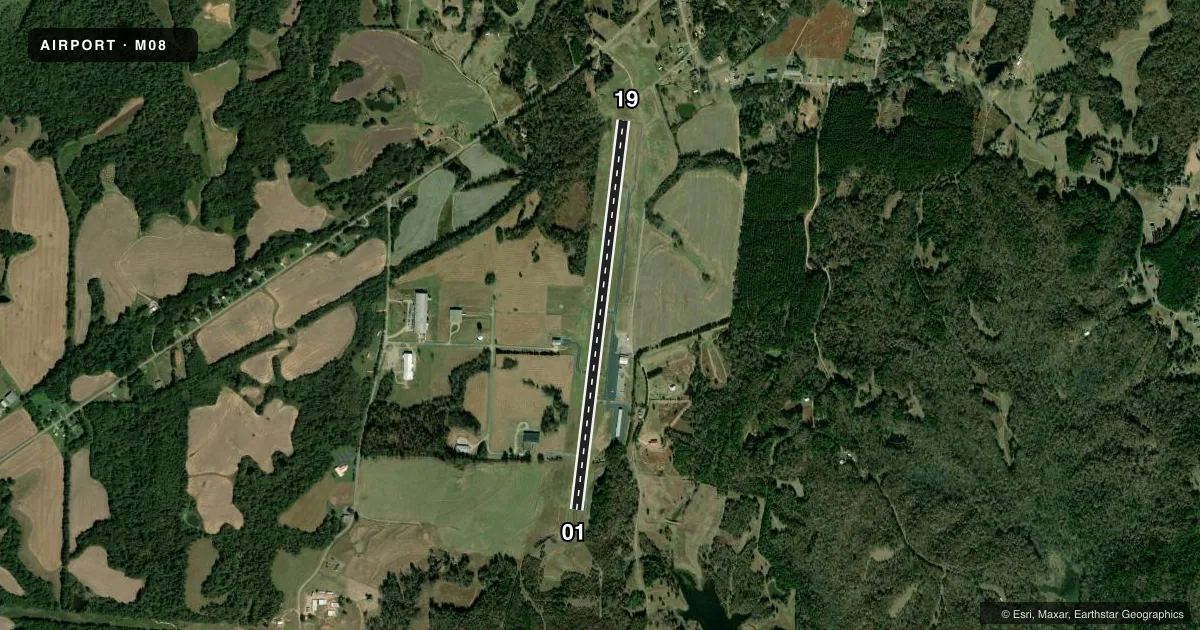
Airport sketch
Runways drawn to scale from FAA survey coordinates, rendered over satellite imagery. Not for navigation.
Approaches & charts
Services on the field
Fuel grades, oxygen, maintenance, ramp storage and lighting — as declared to the FAA by the airport operator.
Fuel & services
- Fuel
- 100LLA
- Airframe repair
- Major
- Power plant repair
- Major
- Other services
- AGRI,INSTR
Ramp & ground
- Transient storage
- Tie-down
- Hangar
- Landing fee
- No fee published
- Customs
- Not available
- Lighting schedule
- SS-SR
- Beacon schedule
- SS-SR
- Beacon
- White / Green (civil land)(WG)
- Wind indicator
- Lighted
- Segmented circle
- Yes
Fuel & FBOs
Cheapest 100LL and Jet A on the field and nearby. Always confirm with the FBO before taxi.
Airport notes
Surface conditions, obstructions, local procedures, lighting outages and other notes published with each FAA cycle.
General notes
- FUEL SVC AVBL H24 WITH CREDIT CARD.
- WILDLIFE INVOF ARPT.
- FOR CD CTC MEMPHIS ARTCC AT 901-368-8453/8449.
Other notes
- THIS AIRPORT HAS BEEN SURVEYED BY THE NATIONAL GEODETIC SURVEY.
- VFR ONLY.
- MANAGERAFT HR 731-658-4547.
VFR map & nearby airports
VFR sectional. Tap any ICAO chip to open that airport.
Key facts · M08
Answer card- ICAO
- M08
- Name
- WILLIAM L WHITEHURST FLD
- Location
- BOLIVAR, TENNESSEE
- Elevation
- 499.1 ft MSL
- Traffic pattern altitude
- 1,499.1 ft MSL (1,000 AGL)
- Control tower
- Non-towered (use CTAF)
- Total runways
- 1
- Longest runway
- 01/19 · 5,007 ft
- Published ILS approaches
- 0
- Published frequencies
- 2
- Magnetic variation
- 2°
- Current flight rules
- MVFR
- Current wind
- 000° at 0 kt
- Favored runway now
- –
William L Whitehurst Fld (M08) is in Bolivar, Tennessee. The field elevation is 499.1 ft MSL. It has one runway, 01/19, which is 5,007 ft long. The airport is not towered. CTAF and UNICOM are both 123.0. No ILS approaches are published here. Pattern altitude is not published, so use the standard 1,000 ft AGL for light piston traffic unless the current Chart Supplement says otherwise.
Hardeman County Airport is the on-field FBO. It carries 100LL and Jet A. Fuel service is available 24 hours with credit card. Wildlife is noted in the vicinity of the airport, so keep a sharp scan on departure and in the pattern. This is a VFR-only field per the published remarks. If you need clearance delivery, contact Memphis ARTCC before departure. After hours, the manager can be reached by phone. With only one asphalt runway and no tower, plan your arrival carefully and make your position reports early on CTAF.