METAR & TAF 25M
25M does not publish a METAR.
Showing the nearest reporting station: KCRX (ROSCOE TURNER) · 23.3 NM away. Conditions at 25M may differ.
METAR · KCRX
Observed 05:55Z
KCRX 270555Z AUTO 00000KT 3SM BR CLR 27/27 A2993 RMK AO2
- Wind
- 000° @ 0 kt
- Visibility
- 3 SM
- Temp / Dew
- 27°C / 27°C
- Altimeter
- 29.93 inHg
- Clouds
- CLR
- Density alt
- 2,007 ft
- Ceiling
- Unlimited
- Rules
- MVFR
Airport info & contacts
Manager on record, flight service, ARTCC, attendance schedule and pattern altitude — published by the FAA and refreshed every 28 days.
Location
- From city
- 3 NM W
- VFR sectional
- MEMPHIS
- ARTCC
- ZME · MEMPHIS
- NOTAM facility
- GWO (NOTAM-D)
Airport manager
- Name
- JOHNNY COOMBS
- Phone
- 662-587-9500
- Address
- PO BOX 127, BLUE MOUNTAIN MS 38610
Flight service · Hours
- FSS GWO
- GREENWOOD1-800-WX-BRIEF
- Attendance
- Unattended
Frequencies
Tap any row to copy the frequency to your clipboard.
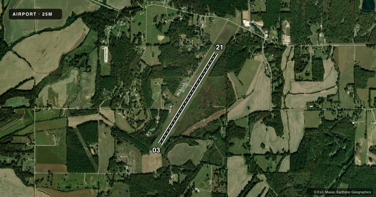
Runways & pattern
Full pagePattern entry · RWY 03
LEFT TRAFFICRunway end performance
| End | TORA | TODA | ASDA | LDA | VGSI | Approach lights | Obstruction |
|---|---|---|---|---|---|---|---|
| 03 | — | — | — | — | PAPI 2-box left(3.25°) | — | 65', tree, 1500' from thr, 300' R of cntrln, slope 20 |
| 21 | — | — | — | — | PAPI 2-box left(3.5°) | — | 65', trees, 1505' from thr, 253' R of cntrln, slope 20 |
Declared distances in feet. TORA = takeoff run available, TODA = takeoff distance, ASDA = accelerate-stop, LDA = landing distance.
Airport sketch
Runways drawn to scale from FAA survey coordinates, rendered over satellite imagery. Not for navigation.
Approaches & charts
Services on the field
Fuel grades, oxygen, maintenance, ramp storage and lighting — as declared to the FAA by the airport operator.
Fuel & services
- Fuel
- 100LLA
- Oxygen (bottled)
- Not available
- Oxygen (bulk)
- Not available
- Airframe repair
- Not available
- Power plant repair
- Not available
Ramp & ground
- Transient storage
- Not published
- Landing fee
- No fee published
- Customs
- Not available
- Lighting schedule
- SEE RMK
- Beacon schedule
- SS-SR
- Beacon
- White / Green (civil land)(WG)
- Wind indicator
- Lighted
- Segmented circle
- Yes
Fuel & FBOs
Cheapest 100LL and Jet A on the field and nearby. Always confirm with the FBO before taxi.
Airport notes
Surface conditions, obstructions, local procedures, lighting outages and other notes published with each FAA cycle.
General notes
- FOR CD CTC MEMPHIS ARTCC AT 901-368-8453/8449.
- COURTESY VAN AVBL.
Lighting notes
- DUSK-2200. AFTER 2200 ACTVT PAPI RWY 03 & 21; MIRL RWY 03/21 - CTAF.
Fuel notes
- 100LLFUEL AVBL 24 HRS WITH CREDIT CARD.
Other notes
- OWNERJOHNNY COOMBS, CHAIRMAN CO ARPT BOARD.
VFR map & nearby airports
VFR sectional. Tap any ICAO chip to open that airport.
Key facts · 25M
Answer card- ICAO
- 25M
- Name
- RIPLEY
- Location
- RIPLEY, MISSISSIPPI
- Elevation
- 466.9 ft MSL
- Traffic pattern altitude
- 1,466.9 ft MSL (1,000 AGL)
- Control tower
- Non-towered (use CTAF)
- Total runways
- 1
- Longest runway
- 03/21 · 4,400 ft
- Published ILS approaches
- 0
- Published frequencies
- 2
- Magnetic variation
- 1°
- Current flight rules
- MVFR
- Current wind
- 000° at 0 kt
- Favored runway now
- –
Ripley Airport is in Ripley, Mississippi. The field elevation is 466.9 ft MSL. It has one runway, 03/21, which is 4,400 ft long on asphalt. This is a non-towered airport. CTAF and UNICOM are both 122.8.
No ILS approaches are published here. The pattern altitude is not published, so use the standard 1,000 ft AGL pattern unless the current Chart Supplement says otherwise. The runway headings are magnetic. Runway 03 is 32° magnetic. Runway 21 is 212° magnetic.
Ripley Airport has one on-field FBO. Ripley Airport carries 100LL and Jet A Prist. 100LL is available 24 hours with a credit card. A courtesy van is available. Lighting is available from dusk to 2200. After 2200, pilots can activate the PAPI and medium intensity runway lights for runways 03 and 21 on CTAF. For clearance delivery, Memphis ARTCC is listed in the remarks.
If you are new to the field, plan for a small non-towered airport with one runway and no published ILS. Check the current Chart Supplement for any updates before departure. That is the best source for current procedures and any changes to lighting or local operations.