METAR & TAF M72
M72 does not publish a METAR.
Showing the nearest reporting station: KTUP (TUPELO RGNL) · 21.0 NM away. Conditions at M72 may differ.
METAR · KTUP
Observed 14:53Z
KTUP 271453Z VRB05KT 10SM CLR 29/24 A2995 RMK AO2 SLP135 T02940239 58017 $
- Wind
- VAR @ 5 kt
- Visibility
- 10 SM
- Temp / Dew
- 29°C / 24°C
- Altimeter
- 29.95 inHg
- Clouds
- CLR
- Density alt
- 2,155 ft
- Ceiling
- Unlimited
- Rules
- VFR
Airport info & contacts
Manager on record, flight service, ARTCC, attendance schedule and pattern altitude — published by the FAA and refreshed every 28 days.
Location
- From city
- 3 NM N
- VFR sectional
- MEMPHIS
- ARTCC
- ZME · MEMPHIS
- NOTAM facility
- GWO (NOTAM-D)
Airport manager
- Name
- RUDY DIXON
- Phone
- 662-534-1050
- Address
- 1034 COUNTY ROAD 80, NEW ALBANY MS 38652
Flight service · Hours
- FSS GWO
- GREENWOOD1-800-WX-BRIEF
- Attendance
- MON-FRI · DALGT
Frequencies
Tap any row to copy the frequency to your clipboard.
Runways & pattern
Full pagePattern entry · RWY 36
LEFT TRAFFICRunway end performance
| End | TORA | TODA | ASDA | LDA | VGSI | Approach lights | Obstruction |
|---|---|---|---|---|---|---|---|
| 18 | — | — | — | — | PAPI 2-box left(3°) | — | 64', trees, 1952' from thr, 28' R of cntrln, slope 27 |
| 36 | — | — | — | — | PAPI 2-box left(3°) | — | 78', trees, 2436' from thr, 0' R of cntrln, slope 28 |
Declared distances in feet. TORA = takeoff run available, TODA = takeoff distance, ASDA = accelerate-stop, LDA = landing distance.
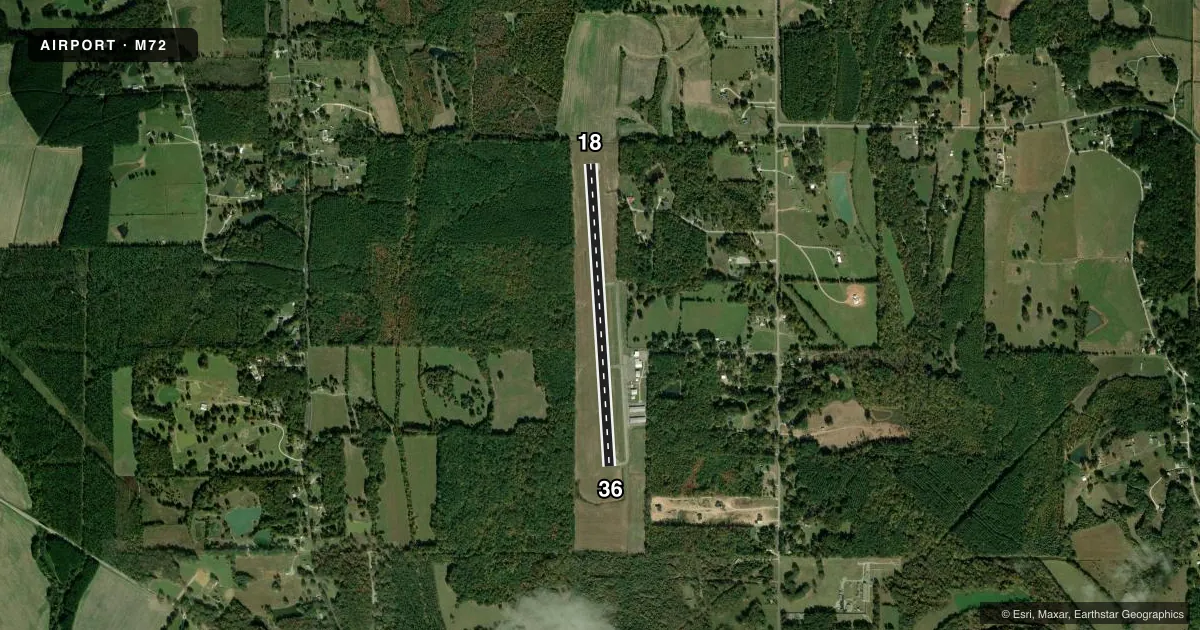
Airport sketch
Runways drawn to scale from FAA survey coordinates, rendered over satellite imagery. Not for navigation.
Approaches & charts
Services on the field
Fuel grades, oxygen, maintenance, ramp storage and lighting — as declared to the FAA by the airport operator.
Fuel & services
- Fuel
- 100LL
- Oxygen (bottled)
- Not available
- Oxygen (bulk)
- Not available
Ramp & ground
- Transient storage
- Tie-down
- Hangar
- Landing fee
- No fee published
- Customs
- Not available
- Lighting schedule
- SEE RMK
- Beacon schedule
- SS-SR
- Beacon
- White / Green (civil land)(WG)
- Wind indicator
- Lighted
- Segmented circle
- No
Fuel & FBOs
Cheapest 100LL and Jet A on the field and nearby. Always confirm with the FBO before taxi.
Airport notes
Surface conditions, obstructions, local procedures, lighting outages and other notes published with each FAA cycle.
General notes
- FOR CD CTC MEMPHIS ARTCC AT 901-368-8453/8449.
Lighting notes
- MIRL RWY 18/36 OPR DUSK-2200.
Fuel notes
- 100LLFUEL AVBL 24 HRS WITH CREDIT CARD.
Other notes
- ON REQ.
- ON REQ.
- PILOTS MUST PRVD THEIR OWN TIEDOWN ROPES.
VFR map & nearby airports
VFR sectional. Tap any ICAO chip to open that airport.
Key facts · M72
Answer card- ICAO
- M72
- Name
- NEW ALBANY/UNION COUNTY
- Location
- NEW ALBANY, MISSISSIPPI
- Elevation
- 412.7 ft MSL
- Traffic pattern altitude
- 1,412.7 ft MSL (1,000 AGL)
- Control tower
- Non-towered (use CTAF)
- Total runways
- 1
- Longest runway
- 18/36 · 3,903 ft
- Published ILS approaches
- 0
- Published frequencies
- 2
- Magnetic variation
- 1°
- Current flight rules
- VFR
- Current wind
- 000° at 5 kt
- Favored runway now
- RWY 36
New Albany/Union County Airport (M72) sits in New Albany, Mississippi. Field elevation is 412.7 ft MSL. The airport has one runway, 18/36, which is 3,903 ft long and paved with asphalt. The runway headings are 176° and 356° magnetic. No control tower is published, so plan on self-announce traffic on CTAF 122.8. Pattern altitude is not published. Use the standard 1,000 ft AGL pattern for light piston aircraft unless current local guidance says otherwise.
No ILS approaches are published here. If you need an instrument option, check the current FAA Chart Supplement before departure. The on-field FBO is New Albany-Union County Airport. It carries 100LL. Call (662) 534-1050 for current service details. The published remarks also note 24-hour self-serve fuel with credit card. Medium intensity runway lights on 18/36 operate from dusk to 2200. That matters if you are planning a late arrival.
This is a non-towered field with UNICOM on 122.8. Clearance delivery is handled through Memphis ARTCC at the published phone numbers in the Chart Supplement. Pilots should also bring their own tiedown ropes. If you are new to the airport, expect a straightforward single-runway layout with standard small-airport traffic flow.