METAR & TAF 5A4
5A4 does not publish a METAR.
Showing the nearest reporting station: KTUP (TUPELO RGNL) · 15.4 NM away. Conditions at 5A4 may differ.
METAR · KTUP
Observed 11:53Z
KTUP 271153Z 03010KT 10SM SCT050 SCT085 26/23 A3000 RMK AO2 SLP152 70001 T02610233 10272 20261 53025 $
- Wind
- 030° @ 10 kt
- Visibility
- 10 SM
- Temp / Dew
- 26°C / 23°C
- Altimeter
- 30.00 inHg
- Clouds
- SCT
- Density alt
- 1,639 ft
- Ceiling
- Unlimited
- Rules
- VFR
Airport info & contacts
Manager on record, flight service, ARTCC, attendance schedule and pattern altitude — published by the FAA and refreshed every 28 days.
Location
- From city
- 2 NM NE
- VFR sectional
- MEMPHIS
- ARTCC
- ZME · MEMPHIS
- NOTAM facility
- GWO (NOTAM-D)
Airport manager
- Name
- CITY OF OKOLONA
- Phone
- 662-447-5461
- Address
- PO BOX 111, OKOLONA MS 38860
Flight service · Hours
- FSS GWO
- GREENWOOD1-800-WX-BRIEF
- Attendance
- Unattended
Frequencies
Tap any row to copy the frequency to your clipboard.
Runways & pattern
Full pagePattern entry · RWY 36
LEFT TRAFFICRunway end performance
| End | TORA | TODA | ASDA | LDA | VGSI | Approach lights | Obstruction |
|---|---|---|---|---|---|---|---|
| 36 | — | — | — | — | — | — | 51', trees, 1535' from thr, 200' R of cntrln, slope 26 |
Declared distances in feet. TORA = takeoff run available, TODA = takeoff distance, ASDA = accelerate-stop, LDA = landing distance.
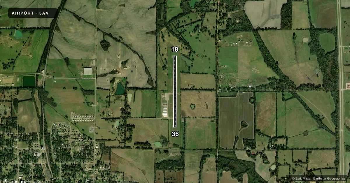
Airport sketch
Runways drawn to scale from FAA survey coordinates, rendered over satellite imagery. Not for navigation.
Approaches & charts
Services on the field
Fuel grades, oxygen, maintenance, ramp storage and lighting — as declared to the FAA by the airport operator.
Fuel & services
- Fuel
- 100LL
- Oxygen (bottled)
- Not available
- Oxygen (bulk)
- Not available
- Airframe repair
- Minor
- Power plant repair
- Minor
- Other services
- AGRI,AVNCS
Ramp & ground
- Transient storage
- Tie-down
- Landing fee
- No fee published
- Lighting schedule
- SEE RMK
- Beacon schedule
- SS-SR
- Beacon
- White / Green (civil land)(WG)
- Wind indicator
- Lighted
- Segmented circle
- Yes
Fuel & FBOs
Cheapest 100LL and Jet A on the field and nearby. Always confirm with the FBO before taxi.
Airport notes
Surface conditions, obstructions, local procedures, lighting outages and other notes published with each FAA cycle.
General notes
- RWY 18/36 TERRAIN DROPS OFF ABRUPTLY 200 FT FM BOTH ENDS.
- FOR CD CTC MEMPHIS ARTCC AT 901-368-8453/8449.
Lighting notes
- ACTVT MIRL RWY 18/36 - CTAF.
Fuel notes
- 100LLFUEL AVBL 24 HR WITH CREDIT CARD.
Other notes
- PILOT MUST PRVD THEIR OWN TIEDOWN ROPES.
- MANAGERSHERMAN CAROUTHERS, MAYOR OF OKOLONA CITY.
- OWNERSHERMAN CAROUTHERS, MAYOR OF OKOLONA CITY.
VFR map & nearby airports
VFR sectional. Tap any ICAO chip to open that airport.
Key facts · 5A4
Answer card- ICAO
- 5A4
- Name
- OKOLONA MUNI/RICHARD STOVALL FLD
- Location
- OKOLONA, MISSISSIPPI
- Elevation
- 337 ft MSL
- Traffic pattern altitude
- 1,337 ft MSL (1,000 AGL)
- Control tower
- Non-towered (use CTAF)
- Total runways
- 1
- Longest runway
- 18/36 · 3,197 ft
- Published ILS approaches
- 0
- Published frequencies
- 3
- Magnetic variation
- 2°
- Current flight rules
- VFR
- Current wind
- 030° at 10 kt
- Favored runway now
- RWY 36
Okolona Muni / Richard Stovall Fld sits in Okolona, Mississippi. Field elevation is 337 ft MSL. The airport has one runway. Runway 18/36 is 3,197 ft long with asphalt surface. There is no control tower. Pattern altitude is not published. Use the standard 1,000 ft AGL pattern for light piston traffic unless local procedures say otherwise.
No ILS approaches are published here. That makes current weather and a good scan of the runway environment more important on arrival. The runway lights for 18/36 are medium intensity and are activated by the CTAF. The field also has abrupt terrain drop-offs about 200 ft from both runway ends. That is worth having in mind on takeoff and landing.
Okolona Municipal Airport is on the field and carries AVGAS 100LL. Fuel is available 24 hours with a credit card. Pilots should bring their own tiedown ropes. For clearance delivery, contact Memphis ARTCC. The airport is in a non-towered environment, so monitor CTAF 122.9 and make standard position calls. If you need current local operating details, check the current FAA Chart Supplement or call the airport operator directly.