METAR & TAF M83
M83 does not publish a METAR.
Showing the nearest reporting station: KGTR (GOLDEN TRIANGLE RGNL) · 9.0 NM away. Conditions at M83 may differ.
METAR · KGTR
Observed 07:56Z
KGTR 270756Z AUTO 00000KT 10SM BKN050 27/26 A2994 RMK AO2 SLP136 T02670256 $
- Wind
- 000° @ 0 kt
- Visibility
- 10 SM
- Temp / Dew
- 27°C / 26°C
- Altimeter
- 29.94 inHg
- Clouds
- BKN
- Density alt
- 1,670 ft
- Ceiling
- 5,000 ft AGL
- Rules
- VFR
Airport info & contacts
Manager on record, flight service, ARTCC, attendance schedule and pattern altitude — published by the FAA and refreshed every 28 days.
Location
- From city
- 2 NM S
- VFR sectional
- MEMPHIS
- ARTCC
- ZME · MEMPHIS
- NOTAM facility
- GWO (NOTAM-D)
Airport manager
- Name
- RANDY JONES
- Phone
- 662-524-0039
- Address
- PO BOX 1117, WEST POINT MS 39773
Flight service · Hours
- FSS GWO
- GREENWOOD1-800-WX-BRIEF
- Attendance
- Unattended
Frequencies
Tap any row to copy the frequency to your clipboard.
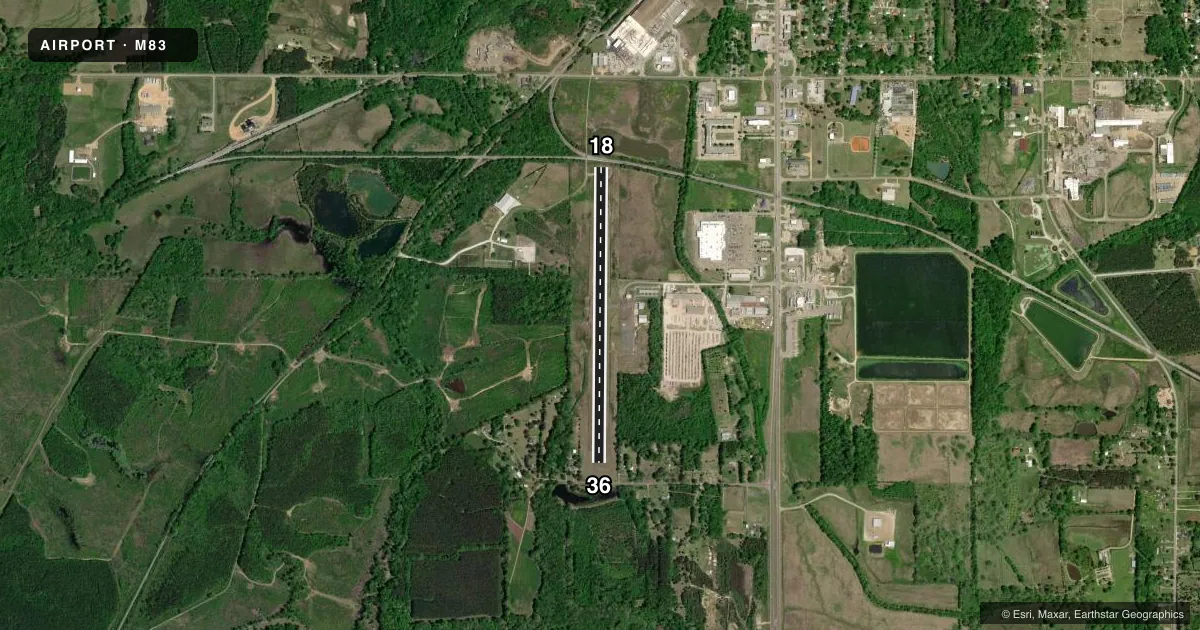
Runways & pattern
Full pagePattern entry · RWY 18
LEFT TRAFFICRunway end performance
| End | TORA | TODA | ASDA | LDA | VGSI | Approach lights | Obstruction |
|---|---|---|---|---|---|---|---|
| 18 | — | — | — | — | — | — | 47', tree, 1400' from thr, 100' R of cntrln, slope 25 |
| 36 | — | — | — | — | — | — | 11', road, 900' from thr, slope 21 |
Declared distances in feet. TORA = takeoff run available, TODA = takeoff distance, ASDA = accelerate-stop, LDA = landing distance.
Airport sketch
Runways drawn to scale from FAA survey coordinates, rendered over satellite imagery. Not for navigation.
Approaches & charts
Services on the field
Fuel grades, oxygen, maintenance, ramp storage and lighting — as declared to the FAA by the airport operator.
Fuel & services
- Fuel
- 100LLA
- Oxygen (bottled)
- Not available
- Oxygen (bulk)
- Not available
- Airframe repair
- Not available
- Power plant repair
- Not available
Ramp & ground
- Transient storage
- Tie-down
- Landing fee
- No fee published
- Customs
- Not available
- Lighting schedule
- SEE RMK
- Beacon schedule
- SS-SR
- Beacon
- White / Green (civil land)(WG)
- Wind indicator
- Lighted
- Segmented circle
- Yes
Fuel & FBOs
Cheapest 100LL and Jet A on the field and nearby. Always confirm with the FBO before taxi.
Airport notes
Surface conditions, obstructions, local procedures, lighting outages and other notes published with each FAA cycle.
General notes
- COURTESY CAR AVBL.
- FOR CD CTC COLUMBUS APCH AT 662-434-3044, WHEN CLSD CTC MEMPHIS ARTCC AT 901-368-8453/8449.
Lighting notes
- DUSK-2200. AFT 2200, ACTVT MIRL RWY 18/36 - CTAF.
Fuel notes
- 100LLFUEL SVC AVBL 24 HR WITH CREDIT CARD.
Approach & departure obstructions
- 18RR 50 FT FM RWY END.
- 364 FT FENCE 200 FT FM END OF RWY.
- 18MARKINGS FADED.
- 36MARKINGS FADED.
- 18APCH RATIO 24:1 FM DTHR.
- 36TREES.
Other notes
- PILOTS MUST PRVD THEIR OWN TIEDOWN ROPES.
VFR map & nearby airports
VFR sectional. Tap any ICAO chip to open that airport.
Key facts · M83
Answer card- ICAO
- M83
- Name
- MCCHAREN FLD
- Location
- WEST POINT, MISSISSIPPI
- Elevation
- 205.2 ft MSL
- Traffic pattern altitude
- 1,205.2 ft MSL (1,000 AGL)
- Control tower
- Non-towered (use CTAF)
- Total runways
- 1
- Longest runway
- 18/36 · 3,850 ft
- Published ILS approaches
- 0
- Published frequencies
- 3
- Magnetic variation
- 0°
- Current flight rules
- VFR
- Current wind
- 000° at 0 kt
- Favored runway now
- –
McCharen Fld sits in West Point, Mississippi. Field elevation is 205.2 ft MSL. The airport has one asphalt runway, 18/36, at 3,850 ft. It is an untowered field. Pattern altitude is not published, so use the standard 1,000 ft AGL for light piston aircraft unless the current FAA Chart Supplement says otherwise.
No ILS approaches are published here. For radio work, CTAF is 122.9. Approach and departure services are listed on 135.6 and 323.275 through Columbus. For clearance delivery, pilots are told to contact Columbus Approach. When that is closed, Memphis ARTCC handles it. The field also has 24-hour 100LL service with credit card use through McCharen Field. JET-A Prist is also listed on field. A courtesy car is available. Pilots need to bring their own tiedown ropes.
This is a field where the runway environment matters. Trees sit near runway 36. There is also a 4-foot fence 200 feet from the end of runway 36. Runway 18 has faded markings. The approach slope from the displaced threshold on runway 18 is 24 to 1. There is also a railroad 50 feet from the end of runway 18. Lighting runs from dusk to 2200. After 2200, medium intensity runway lights on 18/36 are activated on CTAF.