METAR & TAF M40
Current METAR
Observed 05:35Z
KM40 270535Z AUTO 00000KT 3SM BR CLR 26/26 A2996 RMK AO2
- Wind
- 000° @ 0 kt
- Visibility
- 3 SM
- Temp / Dew
- 26°C / 26°C
- Altimeter
- 29.96 inHg
- Clouds
- CLR
- Density alt
- 1,550 ft
- Ceiling
- Unlimited
- Rules
- MVFR
Airport info & contacts
Manager on record, flight service, ARTCC, attendance schedule and pattern altitude — published by the FAA and refreshed every 28 days.
Location
- From city
- 4 NM NE
- VFR sectional
- MEMPHIS
- ARTCC
- ZME · MEMPHIS
- NOTAM facility
- GWO (NOTAM-D)
Airport manager
- Name
- WES KIRKPATRICK
- Phone
- 662-369-4800
- Address
- 50068 AIRPORT RD, ABERDEEN MS 39730
Flight service · Hours
- FSS GWO
- GREENWOOD1-800-WX-BRIEF
- Attendance
- 0800-1700
Frequencies
Tap any row to copy the frequency to your clipboard.
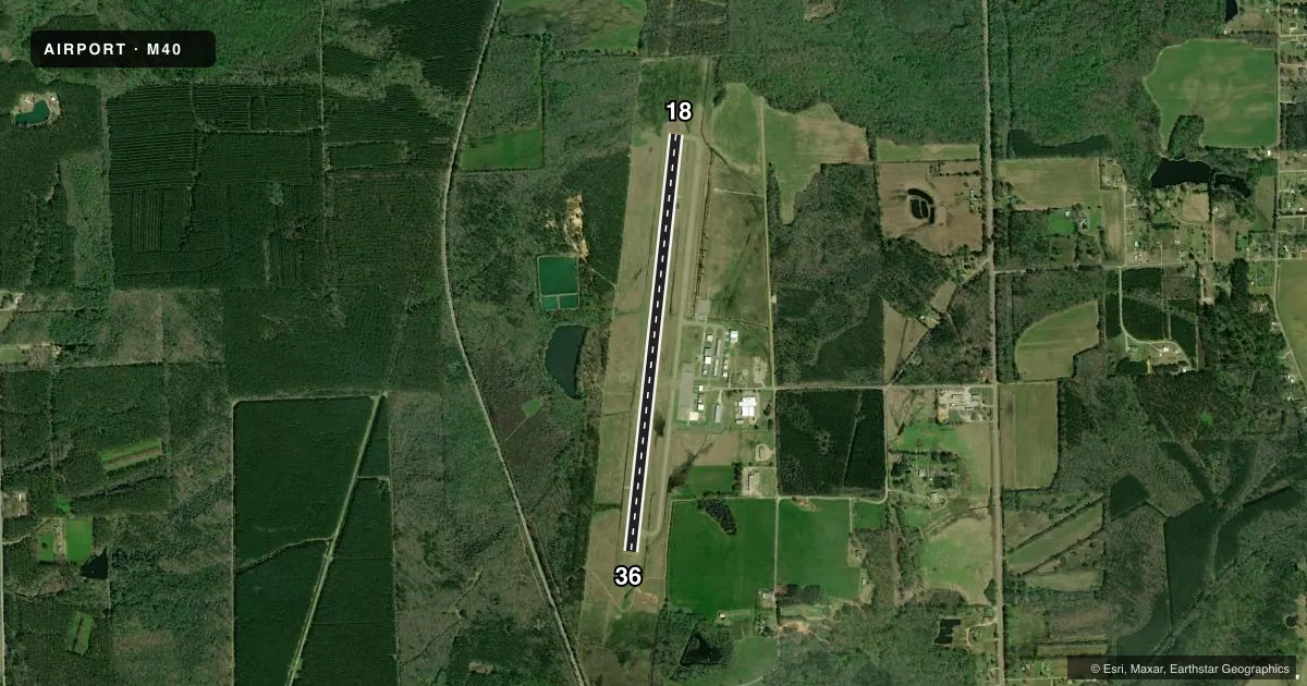
Runways & pattern
Full pagePattern entry · RWY 18
LEFT TRAFFICRunway end performance
| End | TORA | TODA | ASDA | LDA | VGSI | Approach lights | Obstruction |
|---|---|---|---|---|---|---|---|
| 18 | — | — | — | — | PAPI 4-box left(3°) | — | trees, slope 50 |
| 36 | — | — | — | — | PAPI 4-box left(3°) | — | 37', trees, 1600' from thr, slope 37 |
Declared distances in feet. TORA = takeoff run available, TODA = takeoff distance, ASDA = accelerate-stop, LDA = landing distance.
Airport sketch
Runways drawn to scale from FAA survey coordinates, rendered over satellite imagery. Not for navigation.
Approaches & charts
Services on the field
Fuel grades, oxygen, maintenance, ramp storage and lighting — as declared to the FAA by the airport operator.
Fuel & services
- Fuel
- 100LLA
- Oxygen (bottled)
- Not available
- Oxygen (bulk)
- Not available
- Airframe repair
- Major
- Power plant repair
- Major
Ramp & ground
- Transient storage
- Tie-down
- Hangar
- Landing fee
- No fee published
- Customs
- Not available
- Lighting schedule
- SEE RMK
- Beacon schedule
- SS-SR
- Beacon
- White / Green (civil land)(WG)
- Wind indicator
- Lighted
- Segmented circle
- Yes
Fuel & FBOs
Cheapest 100LL and Jet A on the field and nearby. Always confirm with the FBO before taxi.
Airport notes
Surface conditions, obstructions, local procedures, lighting outages and other notes published with each FAA cycle.
General notes
- FOR CD CTC COLUMBUS APCH AT 662-434-3044.
- COURTESY CAR AVBL.
- PAEW ON RWY 18.
Lighting notes
- ACTVT REIL RWY 18 & 36; MIRL RWY 18/36; TWY LGTS - CTAF. PAPI RWY 18 & 36 OPR CONSLY.
Fuel notes
- 100LL24 HR WITH CREDIT CARD.
- AAFT HR JET A FUEL CALL 662-436-6122.
Approach & departure obstructions
- 36UNUSBL BYD 9 DEGS R OF CNTRLN.
Other notes
- PILOTS MUST PRVD THEIR OWN TIEDOWN ROPES.
- OWNERRUBEL WEST, BOARD PRESIDENT.
- MANAGER662-436-6122.
VFR map & nearby airports
VFR sectional. Tap any ICAO chip to open that airport.
Key facts · M40
Answer card- ICAO
- M40
- Name
- MONROE COUNTY
- Location
- ABERDEEN/AMORY, MISSISSIPPI
- Elevation
- 225.8 ft MSL
- Traffic pattern altitude
- 1,225.8 ft MSL (1,000 AGL)
- Control tower
- Non-towered (use CTAF)
- Total runways
- 1
- Longest runway
- 18/36 · 4,999 ft
- Published ILS approaches
- 0
- Published frequencies
- 4
- Magnetic variation
- 2°
- Current flight rules
- MVFR
- Current wind
- 000° at 0 kt
- Favored runway now
- –
Monroe County Airport sits near Aberdeen and Amory in Mississippi. The field elevation is 225.8 ft MSL. It has one runway, 18/36, which is 4,999 ft long and asphalt. There is no control tower. Pattern altitude is not published, so light piston traffic should plan for the standard 1,000 ft AGL unless the current Chart Supplement says otherwise.
No ILS approaches are published here. Clearance delivery is handled through Columbus Approach. The published frequencies include Columbus Approach on 126.075 and 239.25. CTAF and UNICOM are both on 122.8. The on-field FBO is Monroe County Airport. It carries 100LL and Jet A Prist. 100LL is available 24 hours with a credit card. After-hours Jet A is available by calling the airport phone number in the Chart Supplement. A courtesy car is available.
A few operational notes matter here. Runway 18/36 has numerous cracks. The visual glide slope indicator for runway 36 is unusable beyond 9 degrees right of centerline. Runway end identifier lights and medium intensity runway lights are installed on 18/36. Taxiway lights are controlled by CTAF. Pilots should bring their own tiedown ropes. For the latest field status, tie-down details, or any local operating issues, call the airport operator or the FBO directly before departure.