METAR & TAF M55
M55 does not publish a METAR.
Showing the nearest reporting station: KGTR (GOLDEN TRIANGLE RGNL) · 33.7 NM away. Conditions at M55 may differ.
METAR · KGTR
Observed 10:56Z
KGTR 271056Z AUTO 00000KT 10SM CLR 25/24 A2996 RMK AO2 SLP144 T02500239 $
- Wind
- 000° @ 0 kt
- Visibility
- 10 SM
- Temp / Dew
- 25°C / 24°C
- Altimeter
- 29.96 inHg
- Clouds
- CLR
- Density alt
- 1,725 ft
- Ceiling
- Unlimited
- Rules
- VFR
Airport info & contacts
Manager on record, flight service, ARTCC, attendance schedule and pattern altitude — published by the FAA and refreshed every 28 days.
Location
- From city
- 6 NM N
- VFR sectional
- MEMPHIS
- ARTCC
- ZME · MEMPHIS
- NOTAM facility
- ANB (NOTAM-D)
Airport manager
- Name
- GLENN CRAWFORD
- Phone
- 205-695-7718
- Address
- CITY HALL, VERNON AL 35592
Flight service · Hours
- FSS ANB
- ANNISTON1-800-WX-BRIEF
- Attendance
- Unattended
Frequencies
Tap any row to copy the frequency to your clipboard.
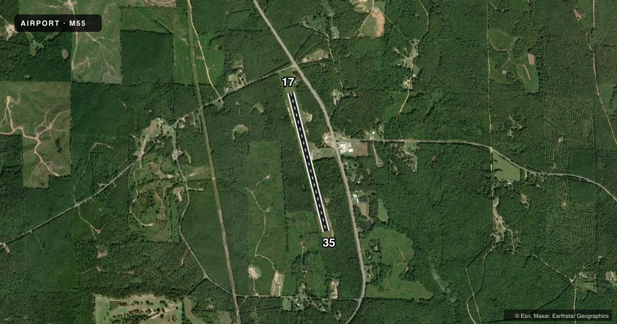
Runways & pattern
Full pagePattern entry · RWY 17
LEFT TRAFFICRunway end performance
| End | TORA | TODA | ASDA | LDA | VGSI | Approach lights | Obstruction |
|---|---|---|---|---|---|---|---|
| 17 | — | — | — | — | PSIL | — | 14', trees, 336' from thr, 137' R of cntrln, slope 9 |
| 35 | — | — | — | — | PSIL | — | 17', trees, 202' from thr, 11' R of cntrln, slope 0 |
Declared distances in feet. TORA = takeoff run available, TODA = takeoff distance, ASDA = accelerate-stop, LDA = landing distance.
Airport sketch
Runways drawn to scale from FAA survey coordinates, rendered over satellite imagery. Not for navigation.
Approaches & charts
Services on the field
Fuel grades, oxygen, maintenance, ramp storage and lighting — as declared to the FAA by the airport operator.
Fuel & services
- Fuel
- Not available
- Oxygen (bottled)
- Not available
- Oxygen (bulk)
- Not available
- Airframe repair
- Not available
- Power plant repair
- Not available
Ramp & ground
- Transient storage
- Not published
- Landing fee
- No fee published
- Customs
- Not available
- Lighting schedule
- SEE RMK
- Wind indicator
- Yes
- Segmented circle
- No
Fuel & FBOs
Cheapest 100LL and Jet A on the field and nearby. Always confirm with the FBO before taxi.
Airport notes
Surface conditions, obstructions, local procedures, lighting outages and other notes published with each FAA cycle.
General notes
- FOR CD CTC MEMPHIS ARTCC AT 901-368-8453/8449.
- ALL ARPT LGT OTS.
Lighting notes
- ARPT LGTS INOP.
Runway surface & condition
- 17/35ARPT LGTS INOP.
Approach & departure obstructions
- 1713 FT TREE 160 FT FM RWY END 111 FT RIGHT OF CNTRLN, 0:1 OBST CLNC; 18 FT TREE 149 FT FM RWY END 126 FT RIGHT OF CNTRLN; 11 FT TREE 163 FT FM RWY END 94 FT RIGHT OF CNTRLN; 6 FT TREE 197 FT FM RWY END 96 FT LEFT OF CNTRLN; 2 FT FENCE 196 FT FM RWY END 109 FT LEFT OF CNTRLN.
- 3511 FT TREE 189 FT FM RWY END 71 FT RIGHT OF CNTRLN, 0:1 OBST CLNC; 22 FT TREE 198 FT FM RWY END 125 FT RIGHT OF CNTRLN; 16 FT TREE 191 FT FM RWY END 74 FT LEFT OF CNTRLN.
- 17RWY MARKINGS POOR DUE TO FADING
- 35RWY MARKINGS POOR DUE TO FADING
Other notes
- THIS AIRPORT HAS BEEN SURVEYED BY THE NATIONAL GEODETIC SURVEY.
- BEFORE FAA ACT.
- 17/35WDSPRD JOINT CRACKING WITH VEGETATION.
VFR map & nearby airports
VFR sectional. Tap any ICAO chip to open that airport.
Key facts · M55
Answer card- ICAO
- M55
- Name
- LAMAR COUNTY
- Location
- VERNON, ALABAMA
- Elevation
- 463 ft MSL
- Traffic pattern altitude
- 1,463 ft MSL (1,000 AGL)
- Control tower
- Non-towered (use CTAF)
- Total runways
- 1
- Longest runway
- 17/35 · 3,613 ft
- Published ILS approaches
- 0
- Published frequencies
- 3
- Magnetic variation
- 2°
- Current flight rules
- VFR
- Current wind
- 000° at 0 kt
- Favored runway now
- –
Lamar County Airport (M55) sits near Vernon, Alabama. Field elevation is 463 ft MSL. The airport has one runway, 17/35, at 3,613 ft asphalt. There is no control tower. No ILS approaches are published. Pattern altitude is not published in the facts, so use the standard 1,000 ft AGL pattern unless the current Chart Supplement says otherwise.
This is a field where the runway condition matters. The published remarks call out widespread joint cracking with vegetation on the runway surface. Runway markings are poor from fading. Airport lights are inoperative. All airport lights are out of service. That makes day VFR planning the safer starting point. The runway ends also have tree obstructions close in. Check your takeoff and landing margins carefully.
No on-field FBOs are listed in the facts. Contact the airport operator directly before arrival, or call the field on CTAF for current FBO availability. For IFR or clearance needs, Memphis ARTCC is listed for clearance delivery. The published frequencies include CTAF 122.9. Approach and departure service is handled by Columbus on 126.075 and 239.25. Pilots should verify current runway condition, lighting status and any local restrictions in the current FAA Chart Supplement before flying in.