METAR & TAF M95
M95 does not publish a METAR.
Showing the nearest reporting station: KJFX (WALKER COUNTY/BEVILL FLD) · 27.6 NM away. Conditions at M95 may differ.
METAR · KJFX
Observed 13:15Z
KJFX 271315Z AUTO 00000KT 10SM FEW120 24/24 A2998 RMK AO2
- Wind
- 000° @ 0 kt
- Visibility
- 10 SM
- Temp / Dew
- 24°C / 24°C
- Altimeter
- 29.98 inHg
- Clouds
- FEW
- Density alt
- 1,449 ft
- Ceiling
- Unlimited
- Rules
- VFR
Airport info & contacts
Manager on record, flight service, ARTCC, attendance schedule and pattern altitude — published by the FAA and refreshed every 28 days.
Location
- From city
- 3 NM NE
- VFR sectional
- ATLANTA
- ARTCC
- ZME · MEMPHIS
- NOTAM facility
- ANB (NOTAM-D)
Airport manager
- Name
- KIP MADISON
- Phone
- 205-932-3819
- Address
- 100 21ST STREET NORTH EAST, FAYETTE AL 35555
Flight service · Hours
- FSS ANB
- ANNISTON1-800-WX-BRIEF
- Attendance
- MON-FRI · 0900-1300
Frequencies
Tap any row to copy the frequency to your clipboard.
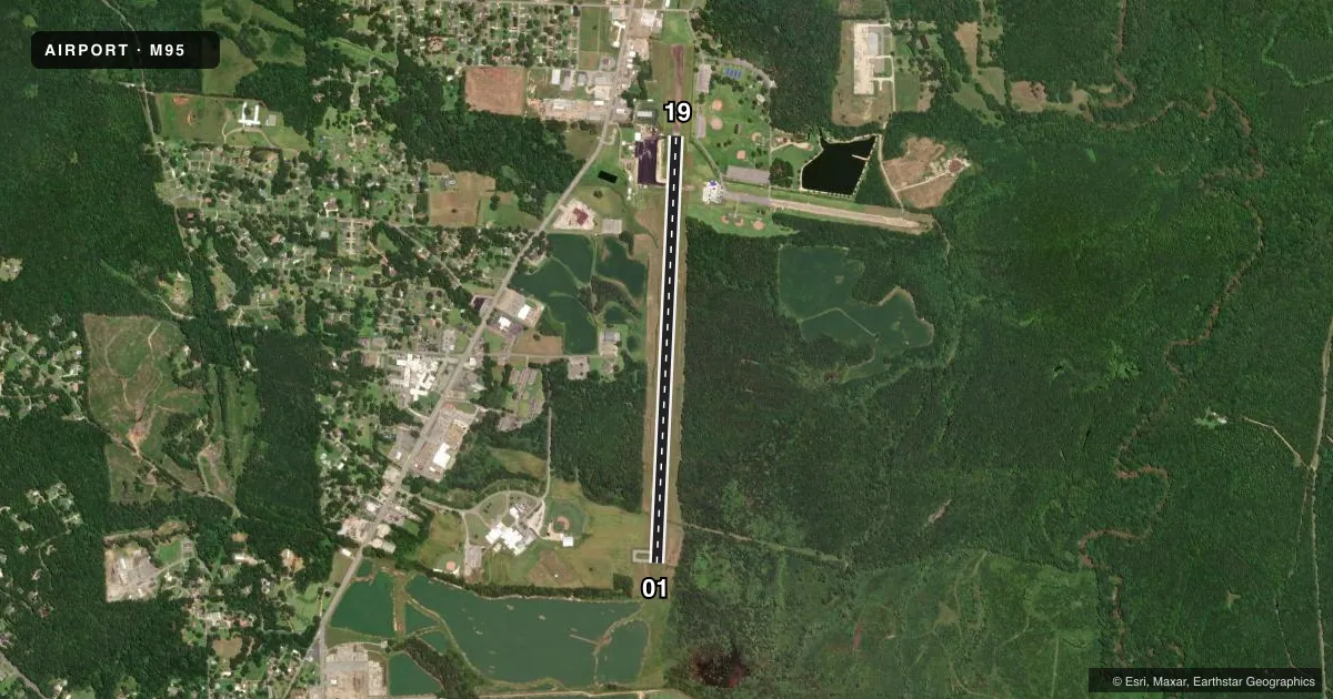
Runways & pattern
Full pagePattern entry · RWY 01
LEFT TRAFFICRunway end performance
| End | TORA | TODA | ASDA | LDA | VGSI | Approach lights | Obstruction |
|---|---|---|---|---|---|---|---|
| 01 | — | — | — | — | PAPI 2-box left(3°) | — | 63', trees, 402' from thr, 273' R of cntrln, slope 3 |
| 19 | — | — | — | — | PAPI 2-box left(3°) | — | 36', trees, 441' from thr, 221' R of cntrln, slope 6 |
Declared distances in feet. TORA = takeoff run available, TODA = takeoff distance, ASDA = accelerate-stop, LDA = landing distance.
Airport sketch
Runways drawn to scale from FAA survey coordinates, rendered over satellite imagery. Not for navigation.
Approaches & charts
Services on the field
Fuel grades, oxygen, maintenance, ramp storage and lighting — as declared to the FAA by the airport operator.
Fuel & services
- Fuel
- 100LLA+
- Oxygen (bottled)
- Not available
- Oxygen (bulk)
- Not available
- Other services
- INSTR
Ramp & ground
- Transient storage
- Tie-down
- Landing fee
- No fee published
- Customs
- Not available
- Lighting schedule
- SEE RMK
- Beacon schedule
- SS-SR
- Beacon
- White / Green (civil land)(WG)
- Wind indicator
- Lighted
- Segmented circle
- Yes
Fuel & FBOs
Cheapest 100LL and Jet A on the field and nearby. Always confirm with the FBO before taxi.
Airport notes
Surface conditions, obstructions, local procedures, lighting outages and other notes published with each FAA cycle.
General notes
- TWY LGTS FOR TWY TURNOFF ONLY.
- DEER ON & INVOF ARPT.
- FOR CD CTC COLUMBUS APCH AT 662-434-3044.
Lighting notes
- ACTVT MIRL RWY 01/19; TWY LGTS - CTAF. PAPI RWY 01 & 19 OPR CONSLY.
Approach & departure obstructions
- 01IDENT, CL AND TRSHLD MKINGS SEVERELY FADED
- 19IDENT, CL AND TRSHLD MKINGS SEVERELY FADED
Other notes
- PRIOR TO FAA ACT.
VFR map & nearby airports
VFR sectional. Tap any ICAO chip to open that airport.
Key facts · M95
Answer card- ICAO
- M95
- Name
- RICHARD ARTHUR FLD
- Location
- FAYETTE, ALABAMA
- Elevation
- 357.4 ft MSL
- Traffic pattern altitude
- 1,357.4 ft MSL (1,000 AGL)
- Control tower
- Non-towered (use CTAF)
- Total runways
- 1
- Longest runway
- 01/19 · 5,009 ft
- Published ILS approaches
- 0
- Published frequencies
- 4
- Magnetic variation
- 3°
- Current flight rules
- VFR
- Current wind
- 000° at 0 kt
- Favored runway now
- –
Richard Arthur Field is in Fayette, Alabama. The field elevation is 357.4 ft MSL. M95 has one runway. Runway 01/19 is 5,009 ft of asphalt, which is the longest runway on the field. There is no control tower. No ILS approaches are published here.
The pattern altitude is not published. Use 1,000 ft AGL for light piston traffic unless the current Chart Supplement says otherwise. The airport sits in a non-towered environment with CTAF and UNICOM on 122.8. Columbus Approach provides approach and departure services on 126.075 and 239.25. For clearance delivery, the published remark says to contact Columbus Approach at 662-434-3044.
Richard Arthur Field has one on-field FBO. Richard Arthur Field carries AVGAS 100LL and Jet A Prist. The published remarks also note medium intensity runway lights on 01/19. The PAPI on runways 01 and 19 operates continuously. Taxiway lights are for turnoff only. The runway 01 and 19 markings are reported as severely faded. Deer are on and near the airport. Plan for wildlife on taxi, takeoff and landing.