METAR & TAF KJFX
Current METAR
Observed 18:35Z
KJFX 241835Z AUTO VRB04KT SCT045 29/18 A3010 RMK AO2 PWINO
- Wind
- VAR @ 4 kt
- Visibility
- —
- Temp / Dew
- 29°C / 18°C
- Altimeter
- 30.10 inHg
- Clouds
- SCT
- Density alt
- 2,055 ft
- Ceiling
- Unlimited
- Rules
- VFR
Airport info & contacts
Manager on record, flight service, ARTCC, attendance schedule and pattern altitude — published by the FAA and refreshed every 28 days.
Location
- From city
- 5 NM NW
- VFR sectional
- ATLANTA
- ARTCC
- ZTL · ATLANTA
- NOTAM facility
- ANB (NOTAM-D)
Airport manager
- Name
- KEITH DUNCAN
- Phone
- 205-388-1294
- Address
- 198 BIDDLE DRIVE, JASPER AL 35503
Flight service · Hours
- FSS ANB
- ANNISTON1-800-WX-BRIEF
- Attendance
- MON - SAT · 0700-2000
Frequencies
Tap any row to copy the frequency to your clipboard.
Runways & pattern
Full pagePattern entry · RWY 27
LEFT TRAFFICRunway end performance
| End | TORA | TODA | ASDA | LDA | VGSI | Approach lights | Obstruction |
|---|---|---|---|---|---|---|---|
| 09 | 5,001' | 5,001' | 4,800' | 4,800' | VASI 4-box left(3°) | — | 11', trees, 230' from thr, 202' R of cntrln, slope 2 |
| 27 | 5,001' | 5,001' | 5,001' | 4,800' | VASI 4-box left(3°) | — | 21', trees, 705' from thr, 64' R of cntrln, slope 24 |
Declared distances in feet. TORA = takeoff run available, TODA = takeoff distance, ASDA = accelerate-stop, LDA = landing distance.
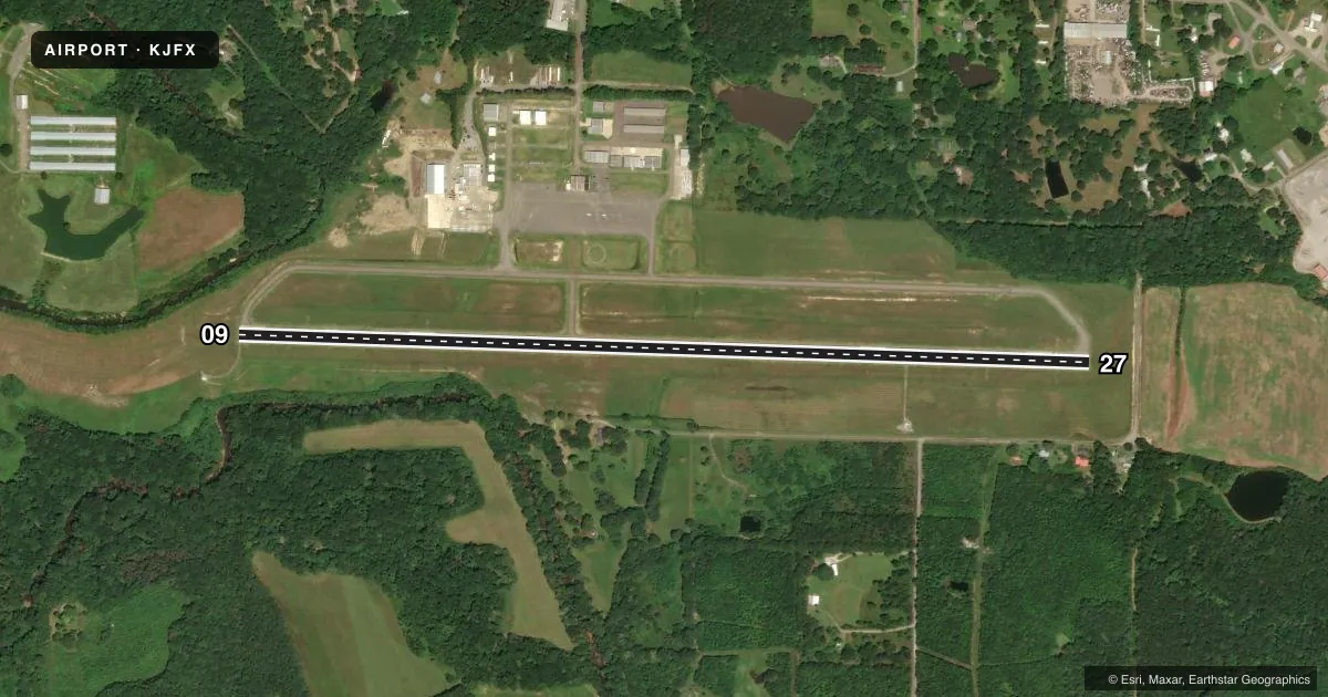
Airport sketch
Runways drawn to scale from FAA survey coordinates, rendered over satellite imagery. Not for navigation.
Approaches & charts
ILS · 1
Services on the field
Fuel grades, oxygen, maintenance, ramp storage and lighting — as declared to the FAA by the airport operator.
Fuel & services
- Fuel
- 100LLAA1
- Oxygen (bottled)
- Not available
- Oxygen (bulk)
- Not available
- Airframe repair
- Major
- Power plant repair
- Major
- Other services
- INSTR,RNTL
Ramp & ground
- Transient storage
- Tie-down
- Landing fee
- No fee published
- Lighting schedule
- SEE RMK
- Beacon schedule
- SS-SR
- Beacon
- White / Green (civil land)(WG)
- Wind indicator
- Lighted
- Segmented circle
- Yes
Fuel & FBOs
Cheapest 100LL and Jet A on the field and nearby. Always confirm with the FBO before taxi.
Airport notes
Surface conditions, obstructions, local procedures, lighting outages and other notes published with each FAA cycle.
General notes
- DEER ON & INVOF RWYS.
- GCO AVBL ON FREQ 121.725 THRU BIRMINGHAM (BHM) CLEARANCE DELIVERY.
- FOR CD IF UNA VIA GCO CTC BIRMINGHAM APCH AT 205-769-3890.
- HVY FLT STUDENT ACT.
Lighting notes
- ACTVT REIL RWY 9 & 27; VASI RWY 9 & 27; MIRL RWY 9/27- CTAF.
Fuel notes
- 100LLFUEL AVBL 24/7 WITH CC.
Other notes
- NO OUTSIDE WORK EXCP EMERGS.
- THIS AIRPORT HAS BEEN SURVEYED BY THE NATIONAL GEODETIC SURVEY.
- NO OUTSIDE WORK EXCP EMERGS.
- OWNERSTEVE MILLER, CHAIRMAN. MIKE SHORT, CO ENGR, KEITH DUNCAN, ARPT MGR.
VFR map & nearby airports
VFR sectional. Tap any ICAO chip to open that airport.
Key facts · KJFX
Answer card- ICAO
- KJFX
- Name
- WALKER COUNTY/BEVILL FLD
- Location
- JASPER, ALABAMA
- Elevation
- 482.6 ft MSL
- Traffic pattern altitude
- 1,482.6 ft MSL (1,000 AGL)
- Control tower
- Non-towered (use CTAF)
- Total runways
- 1
- Longest runway
- 09/27 · 5,004 ft
- Published ILS approaches
- 1
- Published frequencies
- 5
- Magnetic variation
- 1°
- Current flight rules
- VFR
- Current wind
- 000° at 4 kt
- Favored runway now
- RWY 27
Walker County/Bevill Fld sits in Jasper, Alabama. Field elevation is 482.6 ft MSL. The airport has one asphalt runway, 09/27, at 5,004 ft. There is no control tower. Use CTAF 123.075 and expect a busy non-towered pattern. Pattern altitude is not published. Use the standard 1,000 ft AGL pattern unless local procedures or current guidance say otherwise.
Runway 27 has an ILS. The field also has runway end identifier lights, visual approach slope indicators and medium intensity runway lights on 09/27. That helps for night work and marginal weather. Sanders Aviation is on the field. It carries 100LL and Jet A with 24-hour self-serve 100LL available by credit card. Heavy student traffic is published here. Expect training patterns and extra radio calls. Deer are also reported on and near the runways. Keep a sharp scan on taxi, takeoff and landing.
For clearance delivery, ground communications outlet service is available on 121.725 through Birmingham Clearance Delivery. If that does not work, contact Birmingham Approach at the number in the Chart Supplement. This is a good airport to brief carefully before arrival. Know the runway lighting. Watch for student traffic. Plan for a non-towered environment.