METAR & TAF 1M4
Current METAR
Observed 05:56Z
K1M4 250556Z AUTO 00000KT 10SM OVC050 20/19 A3008 RMK AO2 SLP943 T02000189 10250 20194 58004
- Wind
- 000° @ 0 kt
- Visibility
- 10 SM
- Temp / Dew
- 20°C / 19°C
- Altimeter
- 30.08 inHg
- Clouds
- OVC
- Density alt
- 1,555 ft
- Ceiling
- 5,000 ft AGL
- Rules
- VFR
Airport info & contacts
Manager on record, flight service, ARTCC, attendance schedule and pattern altitude — published by the FAA and refreshed every 28 days.
Location
- From city
- 3 NM NE
- VFR sectional
- ATLANTA
- ARTCC
- ZME · MEMPHIS
- NOTAM facility
- ANB (NOTAM-D)
Airport manager
- Name
- BRYAN CRUMPTON
- Phone
- 205-486-8054
- Address
- 721 COUNTY RD 51, HALEYVILLE AL 35565
Flight service · Hours
- FSS ANB
- ANNISTON1-800-WX-BRIEF
- Attendance
- MON-FRI · 0800-1700
Frequencies
Tap any row to copy the frequency to your clipboard.
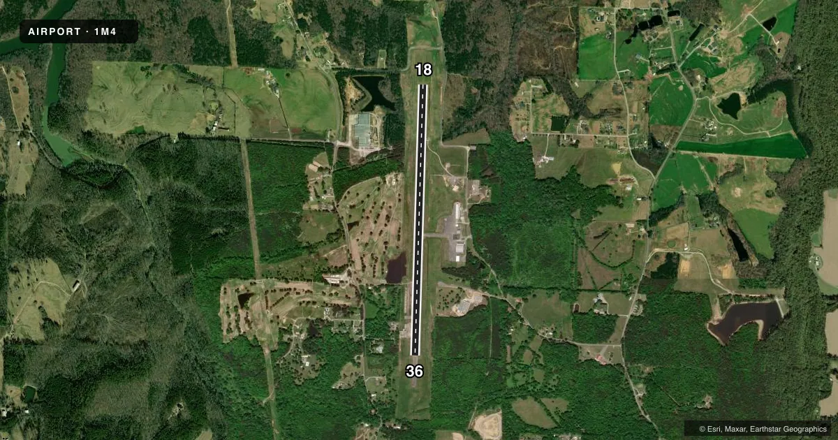
Runways & pattern
Full pagePattern entry · RWY 18
LEFT TRAFFICRunway end performance
| End | TORA | TODA | ASDA | LDA | VGSI | Approach lights | Obstruction |
|---|---|---|---|---|---|---|---|
| 18 | — | — | — | — | PAPI 4-box left(3°) | — | 45', tree, 1067' from thr, 331' R of cntrln, slope 19 |
| 36 | — | — | — | — | PAPI 4-box left(3°) | — | 53', tree, 935' from thr, 318' R of cntrln, slope 13 |
Declared distances in feet. TORA = takeoff run available, TODA = takeoff distance, ASDA = accelerate-stop, LDA = landing distance.
Airport sketch
Runways drawn to scale from FAA survey coordinates, rendered over satellite imagery. Not for navigation.
Approaches & charts
Services on the field
Fuel grades, oxygen, maintenance, ramp storage and lighting — as declared to the FAA by the airport operator.
Fuel & services
- Fuel
- 100LLA+
- Oxygen (bottled)
- Not available
- Oxygen (bulk)
- Not available
- Airframe repair
- Not available
- Power plant repair
- Not available
Ramp & ground
- Transient storage
- Tie-down
- Landing fee
- No fee published
- Customs
- Not available
- Lighting schedule
- SEE RMK
- Beacon schedule
- SS-SR
- Beacon
- White / Green (civil land)(WG)
- Wind indicator
- Lighted
- Segmented circle
- Yes
Fuel & FBOs
Cheapest 100LL and Jet A on the field and nearby. Always confirm with the FBO before taxi.
Airport notes
Surface conditions, obstructions, local procedures, lighting outages and other notes published with each FAA cycle.
General notes
- FOR CD CTC MEMPHIS ARTCC AT 901-368-8453/8449.
- WIDESPREAD CRACKING AND VEGETATION GROWTH ON RAMP.
Lighting notes
- ACTVT REIL RWY 18 & 36; PAPI RWY 18 & 36; MIRL 18/36 - CTAF
Runway surface & condition
- 18/36PCR VALUE: 333/F/D/X/T
Other notes
- PRIOR TO FAA ACT.
- 1FOR SVC AFT HRS CALL 205-494-9527, FUEL UNAVBL WKENDS EXC PRIOR APVL.
VFR map & nearby airports
VFR sectional. Tap any ICAO chip to open that airport.
Key facts · 1M4
Answer card- ICAO
- 1M4
- Name
- POSEY FLD
- Location
- HALEYVILLE, ALABAMA
- Elevation
- 929.8 ft MSL
- Traffic pattern altitude
- 1,929.8 ft MSL (1,000 AGL)
- Control tower
- Non-towered (use CTAF)
- Total runways
- 1
- Longest runway
- 18/36 · 5,008 ft
- Published ILS approaches
- 0
- Published frequencies
- 2
- Magnetic variation
- 1°
- Current flight rules
- VFR
- Current wind
- 000° at 0 kt
- Favored runway now
- –
POSEY FLD sits in Haleyville, Alabama. The field elevation is 929.8 ft MSL. It has one runway. Runway 18/36 is 5,008 ft long and asphalt. There is no control tower. CTAF and UNICOM are both 122.8. No ILS approaches are published here.
Pattern altitude is not published. Use the standard 1,000 ft AGL pattern for light piston aircraft unless the current Chart Supplement says otherwise. The runway lighting is pilot controlled on CTAF. Runway end identifier lights are installed on both ends. Precision approach path indicators are also available on 18 and 36. The runway pavement has a published PCN of 333/F/D/X/T. The ramp has widespread cracking and vegetation growth, so taxi and parking deserve a close look on arrival.
Bailey Aviation is on the field. It carries 100LL and Jet A. For service after hours, call 205-494-9527. Fuel is unavailable on weekends except with prior approval. This is a non-towered field, so plan your calls early and listen carefully on 122.8. If you need clearance delivery, Memphis ARTCC is listed in the remarks. Check the current FAA Chart Supplement for any updates before you go.