METAR & TAF 9A4
Current METAR
Observed 04:35Z
K9A4 270435Z AUTO 00000KT 7SM SCT032 SCT040 SCT046 A2999 RMK AO2
- Wind
- 000° @ 0 kt
- Visibility
- 7 SM
- Temp / Dew
- —
- Altimeter
- 29.99 inHg
- Clouds
- SCT
- Density alt
- —
- Ceiling
- Unlimited
- Rules
- VFR
Airport info & contacts
Manager on record, flight service, ARTCC, attendance schedule and pattern altitude — published by the FAA and refreshed every 28 days.
Location
- From city
- 2 NM NE
- VFR sectional
- ATLANTA
- ARTCC
- ZME · MEMPHIS
- NOTAM facility
- ANB (NOTAM-D)
Airport manager
- Name
- GLENN REIST
- Phone
- 256-318-4536
- Address
- 52 AIR FORCE STREET, COURTLAND AL 35618
Flight service · Hours
- FSS ANB
- ANNISTON1-800-WX-BRIEF
- Attendance
- Unattended
Frequencies
Tap any row to copy the frequency to your clipboard.
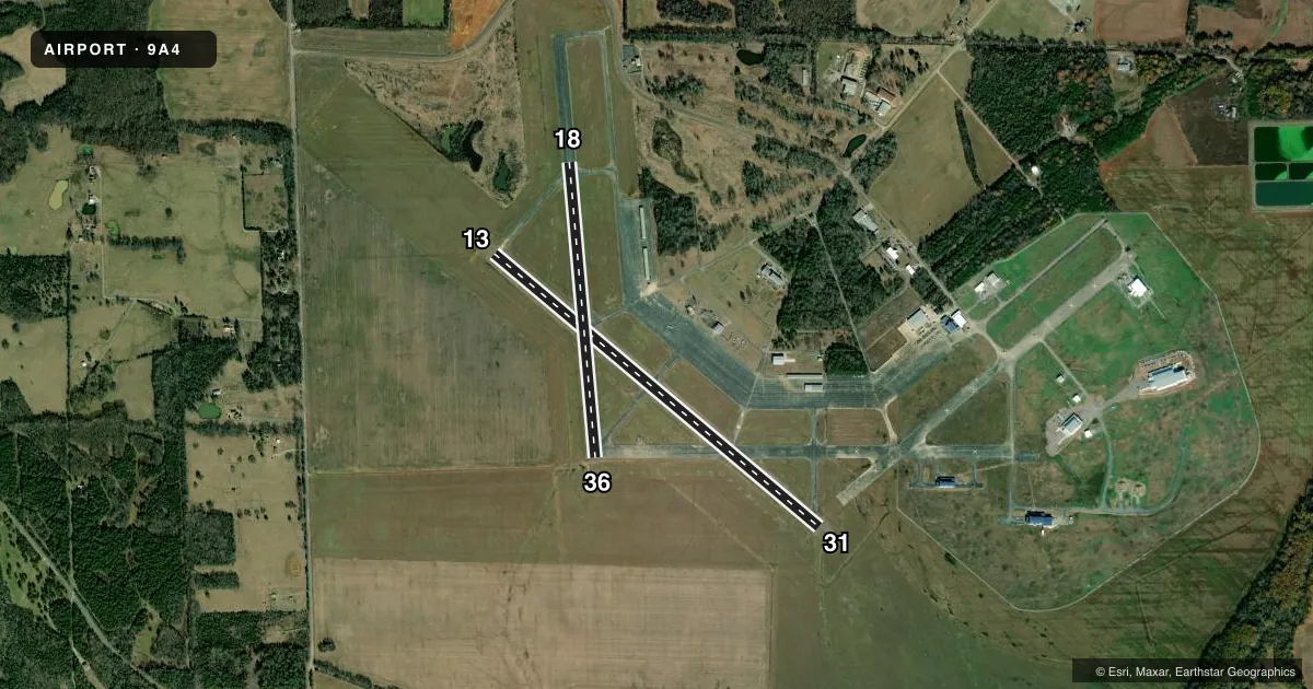
Runways & pattern
Full pagePattern entry · RWY 13
LEFT TRAFFICAirport sketch
Runways drawn to scale from FAA survey coordinates, rendered over satellite imagery. Not for navigation.
Approaches & charts
Services on the field
Fuel grades, oxygen, maintenance, ramp storage and lighting — as declared to the FAA by the airport operator.
Fuel & services
- Fuel
- 100LL
- Oxygen (bottled)
- Not available
- Airframe repair
- Not available
- Power plant repair
- Not available
- Other services
- AGRI
Ramp & ground
- Transient storage
- Tie-down
- Lighting schedule
- SEE RMK
- Beacon schedule
- SS-SR
- Beacon
- White / Green (civil land)(WG)
- Wind indicator
- Lighted
- Segmented circle
- No
Fuel & FBOs
Cheapest 100LL and Jet A on the field and nearby. Always confirm with the FBO before taxi.
Airport notes
Surface conditions, obstructions, local procedures, lighting outages and other notes published with each FAA cycle.
General notes
- FOR CD CTC HUNTSVILLE APCH AT 256-542-2070, WHEN APCH CLSD CTC MEMPHIS ARTCC AT 901-368-8453/8449.
Lighting notes
- HIRL RWY 13/31 PRESET LOW INTST, TO INCR INTST - CTAF. NO TWY LGTS.
Fuel notes
- 100LL100LL FUEL AVBL 24/7 WITH CC.
Approach & departure obstructions
- 13MKNGS SVRLY FADED
- 31MKNGS SVRLY FADED
Other notes
- PRVDD VFR USE ONLY.
- 13/31CONC BLOCKS/JOINTS UNEVEN AT APCH END RWY 31.
VFR map & nearby airports
VFR sectional. Tap any ICAO chip to open that airport.
Key facts · 9A4
Answer card- ICAO
- 9A4
- Name
- COURTLAND
- Location
- COURTLAND, ALABAMA
- Elevation
- 588 ft MSL
- Traffic pattern altitude
- 1,588 ft MSL (1,000 AGL)
- Control tower
- Non-towered (use CTAF)
- Total runways
- 1
- Longest runway
- 13/31 · 4,994 ft
- Published ILS approaches
- 0
- Published frequencies
- 4
- Magnetic variation
- 3°
- Current flight rules
- VFR
- Current wind
- 000° at 0 kt
- Favored runway now
- –
Courtland Airport sits in Courtland, Alabama at 588 ft MSL. It has two concrete runways. The longest is 4,994 ft on runway 13/31. Runway 18/36 is 3,484 ft. There is no control tower. CTAF and UNICOM are both 122.7. Approach and departure service is through Huntsville on 118.05 and 239.0. No ILS approaches are published here.
Pattern altitude is not published. Use the standard 1,000 ft AGL pattern unless the current Chart Supplement or local procedures say otherwise. The field is listed for VFR use only. That matters here because runway 18/36 has rough concrete, including potholes and loose chunks near the runway 36 end. The published remarks also call out uneven concrete blocks and joints near the approach end of runway 31. Markings on runways 13, 31 and 36 are faded.
Courtland Airport has one on-field FBO, Courtland Airport. It carries 100LL. 100LL is available 24 hours a day with a credit card. High intensity lights on runway 13/31 come up in low intensity by default. Use the CTAF to increase them. There are no taxiway lights. If you need clearance delivery, contact Huntsville Approach. If approach is closed, use Memphis ARTCC. Plan for a small, non-towered field with limited lighting. The runway surface deserves a close look before landing.