METAR & TAF KDCU
Current METAR
Observed 11:53Z
KDCU 271153Z AUTO 00000KT 10SM FEW090 FEW110 23/23 A2994 RMK AO2 RAE20 TSE02 SLP129 P0003 60011 70011 T02280228 10278 20228 50006 $
- Wind
- 000° @ 0 kt
- Visibility
- 10 SM
- Temp / Dew
- 23°C / 23°C
- Altimeter
- 29.94 inHg
- Clouds
- FEW
- Density alt
- 1,669 ft
- Ceiling
- Unlimited
- Rules
- VFR
Airport info & contacts
Manager on record, flight service, ARTCC, attendance schedule and pattern altitude — published by the FAA and refreshed every 28 days.
Location
- From city
- 3 NM NE
- VFR sectional
- ATLANTA
- ARTCC
- ZME · MEMPHIS
- NOTAM facility
- DCU (NOTAM-D)
Airport manager
- Name
- ADAM FOX
- Phone
- 256-355-5770
- Address
- PRYOR FIELD AIRPORT AUTHORITY, P.O. BOX 1182, DECATUR AL 35602
Flight service · Hours
- FSS ANB
- ANNISTON1-800-WX-BRIEF
- Attendance
- MAR-NOV · MON-FRI · 0700-1900
- SAT-SUN · 0800-1700
- DEC-FEB · MON-FRI · 0700-1800
Frequencies
Tap any row to copy the frequency to your clipboard.
Runways & pattern
Full pagePattern entry · RWY 18
LEFT TRAFFICRunway end performance
| End | TORA | TODA | ASDA | LDA | VGSI | Approach lights | Obstruction |
|---|---|---|---|---|---|---|---|
| 36 | — | — | — | — | PAPI 2-box left(3°) | — | — |
Declared distances in feet. TORA = takeoff run available, TODA = takeoff distance, ASDA = accelerate-stop, LDA = landing distance.
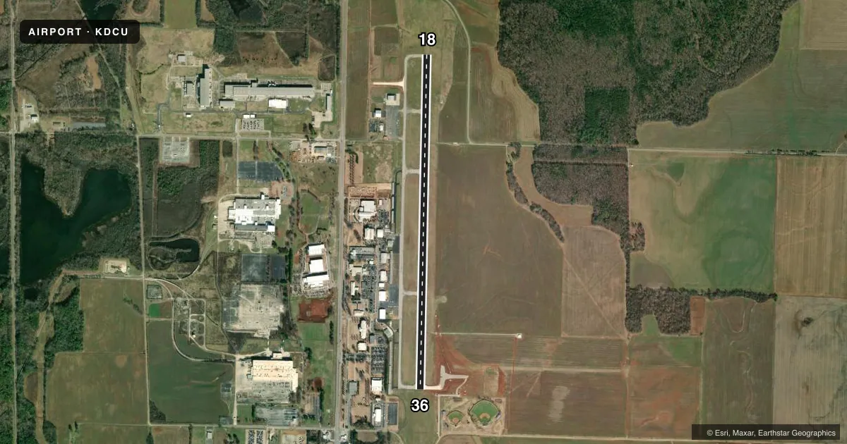
Airport sketch
Runways drawn to scale from FAA survey coordinates, rendered over satellite imagery. Not for navigation.
Approaches & charts
ILS · 1
Services on the field
Fuel grades, oxygen, maintenance, ramp storage and lighting — as declared to the FAA by the airport operator.
Fuel & services
- Fuel
- 100LLA+
- Oxygen (bottled)
- HIGH/LOW
- Oxygen (bulk)
- Not available
- Airframe repair
- Major
- Power plant repair
- Major
- Other services
- AFRT,CARGO,INSTR,RNTL,SALES
Ramp & ground
- Transient storage
- Tie-down
- Hangar
- Landing fee
- No fee published
- Customs
- Not available
- Lighting schedule
- SEE RMK
- Beacon schedule
- SS-SR
- Beacon
- White / Green (civil land)(WG)
- Wind indicator
- Lighted
- Segmented circle
- Yes
Fuel & FBOs
Cheapest 100LL and Jet A on the field and nearby. Always confirm with the FBO before taxi.
Airport notes
Surface conditions, obstructions, local procedures, lighting outages and other notes published with each FAA cycle.
General notes
- FOR CD CTC HUNTSVILLE APCH AT 256-542-2070. WHEN APCH CLSD CTC MEMPHIS ARTCC AT 901-368-8453/8449.
- ARPT UNATTD THANKSGIVING, CHRISTMAS, NEW YEARS
Lighting notes
- ACTVT REIL RWYS 18 & 36; PAPI RWY 36; HIRL RWY 18/36- CTAF.
Runway surface & condition
- 18/3625 FT PAVED SHOULDERS WITH GRASS.
Other notes
- 1FOR ATTENDANT AFT HRS CALL 256-280-1184
VFR map & nearby airports
VFR sectional. Tap any ICAO chip to open that airport.
Key facts · KDCU
Answer card- ICAO
- KDCU
- Name
- PRYOR FLD RGNL
- Location
- DECATUR, ALABAMA
- Elevation
- 592 ft MSL
- Traffic pattern altitude
- 1,592 ft MSL (1,000 AGL)
- Control tower
- Non-towered (use CTAF)
- Total runways
- 1
- Longest runway
- 18/36 · 6,107 ft
- Published ILS approaches
- 1
- Published frequencies
- 4
- Magnetic variation
- 4°
- Current flight rules
- VFR
- Current wind
- 000° at 0 kt
- Favored runway now
- –
Pryor Field Regional Airport sits in Decatur, Alabama. The field elevation is 592 ft MSL. It has one runway. Runway 18/36 is 6,107 ft long with asphalt pavement. The airport is unattended on Thanksgiving, Christmas and New Year's Day. Pattern altitude is not published in the facts. Verify the current Chart Supplement before you fly. For light piston traffic, a standard 1,000 ft AGL pattern is often used. Confirm before departure.
KDCU has no control tower. CTAF and UNICOM are both 123.075. Huntsville Approach handles approach and departure on 118.05 and 239.0. There is one ILS approach. It serves runway 18. Runway 36 has a PAPI. Runways 18 and 36 also have high intensity runway lights controlled by CTAF. Runway 18/36 has 25-foot paved shoulders with grass. Stay centered on rollout and taxi with care near the edges.
Pryor Flight Center is on the field. It carries 100LL, Jet A and Jet A Prist. If you need an attendant after hours, call the number in the Chart Supplement or contact the FBO directly. For clearance delivery, Huntsville Approach is the published contact when available. When Huntsville Approach is closed, use Memphis ARTCC. First-time arrivals should plan for an uncontrolled field with published instrument capability and standard mid-size regional airport traffic flow.