METAR & TAF M38
M38 does not publish a METAR.
Showing the nearest reporting station: KMDQ (HUNTSVILLE EXEC TOM SHARP JR FLD) · 5.6 NM away. Conditions at M38 may differ.
METAR · KMDQ
Observed 13:15Z
KMDQ 271315Z AUTO 10SM CLR 23/22 A2996 RMK A02 T02310224
- Wind
- Calm
- Visibility
- 10 SM
- Temp / Dew
- 23°C / 22°C
- Altimeter
- 29.96 inHg
- Clouds
- CLR
- Density alt
- 1,920 ft
- Ceiling
- Unlimited
- Rules
- VFR
Airport info & contacts
Manager on record, flight service, ARTCC, attendance schedule and pattern altitude — published by the FAA and refreshed every 28 days.
Location
- From city
- 4 NM W
- VFR sectional
- ATLANTA
- ARTCC
- ZME · MEMPHIS
- NOTAM facility
- ANB (NOTAM-D)
Airport manager
- Name
- AARON WYPYSZYNSKI
- Phone
- 256-361-9357
- Address
- 342 OPP REYNOLDS RD, HAZEL GREEN AL 35750
Flight service · Hours
- FSS ANB
- ANNISTON1-800-WX-BRIEF
- Attendance
- TUE-SAT · 0800-1700
Frequencies
Tap any row to copy the frequency to your clipboard.
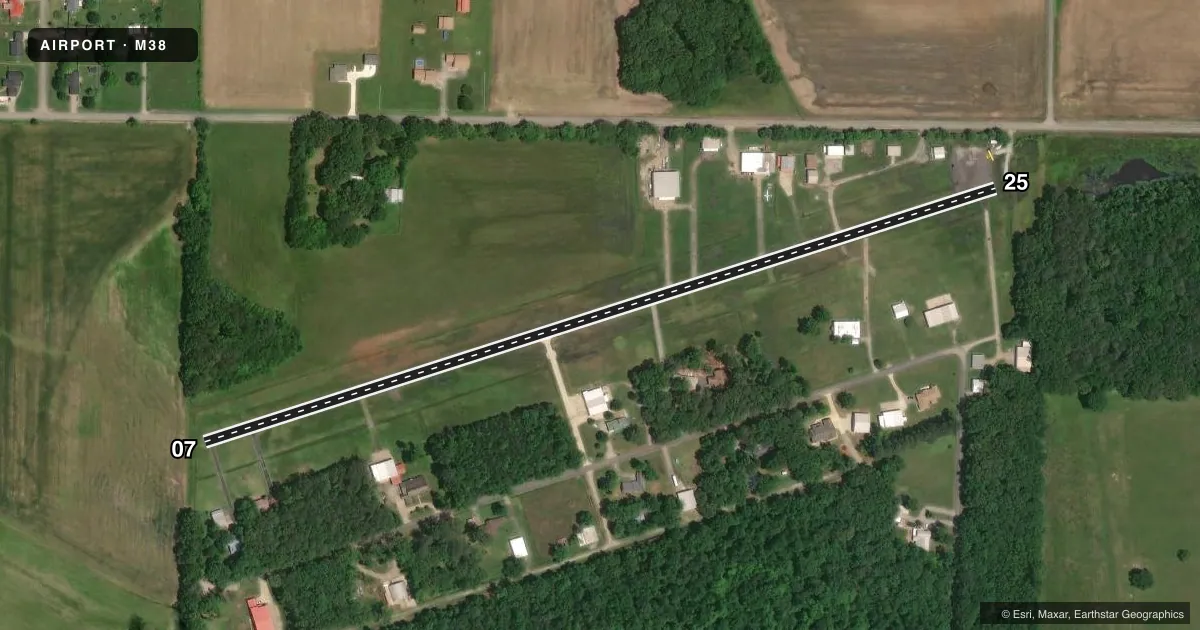
Runways & pattern
Full pagePattern entry · RWY 07
LEFT TRAFFICRunway end performance
| End | TORA | TODA | ASDA | LDA | VGSI | Approach lights | Obstruction |
|---|---|---|---|---|---|---|---|
| 07 | — | — | — | — | — | — | 65', tree, 1433' from thr, 139' R of cntrln, slope 18 |
| 25 | — | — | — | — | — | — | 56', trees, 200' from thr, 75' R of cntrln, slope 0 |
Declared distances in feet. TORA = takeoff run available, TODA = takeoff distance, ASDA = accelerate-stop, LDA = landing distance.
Airport sketch
Runways drawn to scale from FAA survey coordinates, rendered over satellite imagery. Not for navigation.
Approaches & charts
Services on the field
Fuel grades, oxygen, maintenance, ramp storage and lighting — as declared to the FAA by the airport operator.
Fuel & services
- Fuel
- 100LL
- Oxygen (bottled)
- Not available
- Oxygen (bulk)
- Not available
Ramp & ground
- Transient storage
- Tie-down
- Landing fee
- No fee published
- Customs
- Not available
- Lighting schedule
- SEE RMK
- Beacon schedule
- SS-SR
- Beacon
- White / Green (civil land)(WG)
- Wind indicator
- Yes
- Segmented circle
- No
Fuel & FBOs
Cheapest 100LL and Jet A on the field and nearby. Always confirm with the FBO before taxi.
Airport notes
Surface conditions, obstructions, local procedures, lighting outages and other notes published with each FAA cycle.
General notes
- TWY LGTS FOR TWY TURNOFF ONLY.
- FOR CD CTC HUNTSVILLE APCH AT 256-542-2070, WHEN APCH CLSD CTC MEMPHIS ARTCC AT 901-368-8453/8449.
- FUEL FOR HGF, INC MEMBERS ONLY.
Lighting notes
- ACTVT LIRL RWY 07/25 - CTAF.
Approach & departure obstructions
- 25+77 FT TREES 167 FT TO 200 FT FM RWY THR, 75 FT LEFT OF CNTRLN.
- 25APCH RATIO 9:1 TO DSPLCD THR.
Other notes
- VFR USE ONLY
- MANAGERPRESIDENT, HAZEL GREEN FLYERS, INC
- MANAGERHAZELGREENFLYERSM38@GMAIL.COM
VFR map & nearby airports
VFR sectional. Tap any ICAO chip to open that airport.
Key facts · M38
Answer card- ICAO
- M38
- Name
- HAZEL GREEN
- Location
- HAZEL GREEN, ALABAMA
- Elevation
- 814 ft MSL
- Traffic pattern altitude
- 1,814 ft MSL (1,000 AGL)
- Control tower
- Non-towered (use CTAF)
- Total runways
- 1
- Longest runway
- 07/25 · 2,670 ft
- Published ILS approaches
- 0
- Published frequencies
- 3
- Magnetic variation
- 0°
- Current flight rules
- VFR
- Current wind
- Calm / unavailable
- Favored runway now
- –
Hazel Green Airport sits in Hazel Green, Alabama. Field elevation is 814 ft MSL. The airport has one runway. Runway 07/25 is 2,670 ft long and asphalt. This is a non-towered field. CTAF and UNICOM are both 122.8. APCH/P DEP is 125.6 with Huntsville. No ILS approaches are published, so plan for VFR only operations. The published pattern altitude is not given. Use the standard 1,000 ft AGL for light piston traffic unless the current Chart Supplement says otherwise.
The published remarks matter here. Fuel is for Hazel Green Flyers, Inc. members only. If you need fuel access or field coordination, contact the manager directly. Low intensity runway lights on 07/25 are activated by using the common traffic advisory frequency. There is also a published obstacle note on the 25 end. The approach slope ratio is 9 to 1 to the displaced threshold. There are 77 ft trees near that threshold, left of centerline. Taxiway lights are for taxiway turnoff only. For clearance delivery, contact Huntsville Approach. If approach is closed, use Memphis ARTCC. Pilots should treat this as a small VFR field with limited published instrument support. Pay close attention to the departure and arrival path near runway 25.