METAR & TAF KGZS
Current METAR
Observed 11:35Z
KGZS 271135Z AUTO 00000KT 10SM 23/23 A2997 RMK A01
- Wind
- 000° @ 0 kt
- Visibility
- 10 SM
- Temp / Dew
- 23°C / 23°C
- Altimeter
- 29.97 inHg
- Clouds
- Clear
- Density alt
- 1,752 ft
- Ceiling
- Unlimited
- Rules
- VFR
Airport info & contacts
Manager on record, flight service, ARTCC, attendance schedule and pattern altitude — published by the FAA and refreshed every 28 days.
Location
- From city
- 3 NM SW
- VFR sectional
- ATLANTA
- ARTCC
- ZME · MEMPHIS
- NOTAM facility
- MKL (NOTAM-D)
Airport manager
- Name
- RANDY JONES
- Phone
- 931-363-6827
- Address
- 1736 BETHEL RD, PULASKI TN 38478
Flight service · Hours
- FSS MKL
- JACKSON1-800-WX-BRIEF
- Attendance
- MON-SAT · 0800-1900
- SUN · 1300-1800
Frequencies
Tap any row to copy the frequency to your clipboard.
Runways & pattern
Full pagePattern entry · RWY 16
LEFT TRAFFICRunway end performance
| End | TORA | TODA | ASDA | LDA | VGSI | Approach lights | Obstruction |
|---|---|---|---|---|---|---|---|
| 16 | — | — | — | — | PAPI 2-box left(3.8°) | — | — |
| 34 | — | — | — | — | PAPI 2-box left(3°) | — | 74', tower, 1768' from thr, 458' R of cntrln, slope 21 |
Declared distances in feet. TORA = takeoff run available, TODA = takeoff distance, ASDA = accelerate-stop, LDA = landing distance.
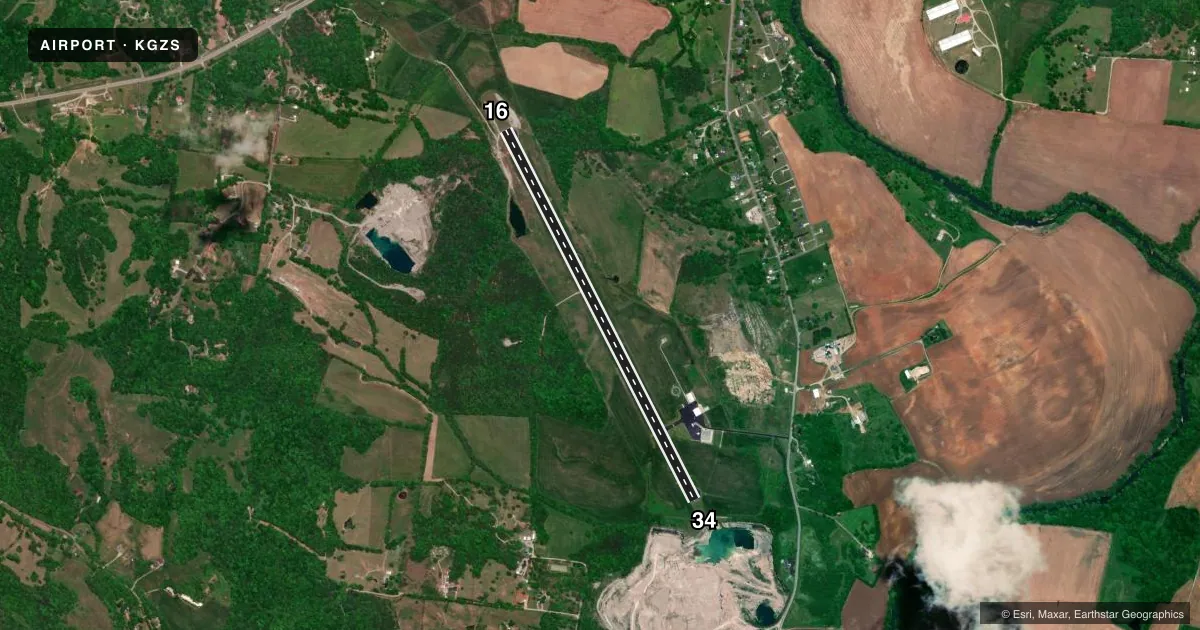
Airport sketch
Runways drawn to scale from FAA survey coordinates, rendered over satellite imagery. Not for navigation.
Approaches & charts
Services on the field
Fuel grades, oxygen, maintenance, ramp storage and lighting — as declared to the FAA by the airport operator.
Fuel & services
- Fuel
- 100LLA+
- Airframe repair
- Major
- Power plant repair
- Major
- Other services
- INSTR,RNTL
Ramp & ground
- Transient storage
- Tie-down
- Landing fee
- No fee published
- Customs
- Not available
- Lighting schedule
- SS-SR
- Beacon schedule
- SS-SR
- Beacon
- White / Green (civil land)(WG)
- Wind indicator
- Lighted
- Segmented circle
- Yes
Fuel & FBOs
Cheapest 100LL and Jet A on the field and nearby. Always confirm with the FBO before taxi.
Airport notes
Surface conditions, obstructions, local procedures, lighting outages and other notes published with each FAA cycle.
General notes
- ROCK QUARRY 1000 FT FM RWY 34; XPLOS OPS SKED IN ADVN WITH ARPT.
- FOR CD CTC MEMPHIS ARTCC AT 901-368-8453/8449.
Approach & departure obstructions
- 34APCH SLOPE 51:1 TO DTHR.
- 34ROCK QUARRY TWR.
Other notes
- THIS AIRPORT HAS BEEN SURVEYED BY THE NATIONAL GEODETIC SURVEY.
- 1CLSD CHRISTMAS.
- 1AFT HR - AMGR.
VFR map & nearby airports
VFR sectional. Tap any ICAO chip to open that airport.
Key facts · KGZS
Answer card- ICAO
- KGZS
- Name
- ABERNATHY FLD
- Location
- PULASKI, TENNESSEE
- Elevation
- 688.8 ft MSL
- Traffic pattern altitude
- 1,688.8 ft MSL (1,000 AGL)
- Control tower
- Non-towered (use CTAF)
- Total runways
- 1
- Longest runway
- 16/34 · 5,310 ft
- Published ILS approaches
- 0
- Published frequencies
- 2
- Magnetic variation
- 2°
- Current flight rules
- VFR
- Current wind
- 000° at 0 kt
- Favored runway now
- –
Abernathy Fld sits in Pulaski, Tennessee. The field elevation is 688.8 ft MSL. It has one runway. Runway 16/34 is 5,310 ft of asphalt, so it gives you a solid strip for light aircraft and many business aircraft. The airport is non-towered. CTAF and UNICOM are both 122.8. No ILS approaches are published here.
The pattern altitude is not published. Use 1,000 ft AGL for light piston operations unless the current Chart Supplement or local procedures say otherwise. The published remarks matter here. There is a rock quarry about 1,000 ft from runway 34. A quarry tower is also noted near that end. The runway 34 displaced threshold has a 51 to 1 approach slope note. That is worth a close look on arrival and departure planning.
After hours, contact the airport manager. The airport is closed on Christmas. For clearance delivery, Memphis ARTCC is listed in the remarks. No on-field FBOs are listed in the facts, so verify fuel and services with the airport operator or the FBO directly by phone before you go.