METAR & TAF KMDQ
Current METAR
Observed 12:15Z
KMDQ 271215Z AUTO 10SM SCT006 23/23 A2996 RMK A02 T02270226
- Wind
- Calm
- Visibility
- 10 SM
- Temp / Dew
- 23°C / 23°C
- Altimeter
- 29.96 inHg
- Clouds
- SCT
- Density alt
- 1,857 ft
- Ceiling
- Unlimited
- Rules
- VFR
Airport info & contacts
Manager on record, flight service, ARTCC, attendance schedule and pattern altitude — published by the FAA and refreshed every 28 days.
Location
- From city
- 1 NM NE
- VFR sectional
- ATLANTA
- ARTCC
- ZME · MEMPHIS
- NOTAM facility
- MDQ (NOTAM-D)
Airport manager
- Name
- LEVI WILLOUGHBY
- Phone
- 770-710-2518
- Address
- 360 CLYDE SHELTON DRIVE, MERIDIANVILLE AL 35759
Flight service · Hours
- FSS ANB
- ANNISTON1-800-WX-BRIEF
- Attendance
- MON-FRI · 0730-2130
- SAT-SUN · 0730-2000
Frequencies
Tap any row to copy the frequency to your clipboard.
Runways & pattern
Full pagePattern entry · RWY 18
LEFT TRAFFICRunway end performance
| End | TORA | TODA | ASDA | LDA | VGSI | Approach lights | Obstruction |
|---|---|---|---|---|---|---|---|
| 18 | — | — | — | — | PAPI 4-box left(3°) | — | 39', trees, 1074' from thr, 204' R of cntrln, slope 22 |
| 36 | — | — | — | — | PAPI 4-box left(3°) | — | — |
Declared distances in feet. TORA = takeoff run available, TODA = takeoff distance, ASDA = accelerate-stop, LDA = landing distance.
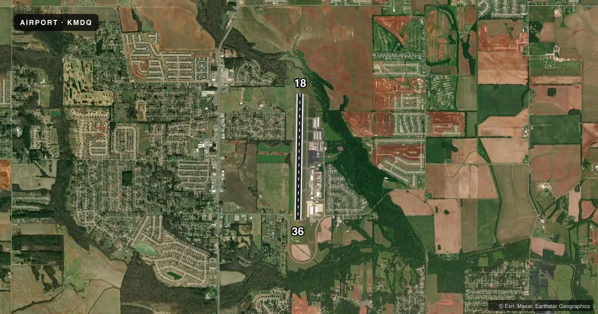
Airport sketch
Runways drawn to scale from FAA survey coordinates, rendered over satellite imagery. Not for navigation.
Approaches & charts
ILS · 1
Services on the field
Fuel grades, oxygen, maintenance, ramp storage and lighting — as declared to the FAA by the airport operator.
Fuel & services
- Fuel
- 100LLA
- Oxygen (bottled)
- Not available
- Oxygen (bulk)
- Low pressure
- Airframe repair
- Major
- Power plant repair
- Major
- Other services
- INSTR,RNTL
Ramp & ground
- Transient storage
- Tie-down
- Hangar
- Landing fee
- No fee published
- Customs
- Not available
- Lighting schedule
- SEE RMK
- Beacon schedule
- SS-SR
- Beacon
- White / Green (civil land)(WG)
- Wind indicator
- Lighted
- Segmented circle
- Yes
Fuel & FBOs
Cheapest 100LL and Jet A on the field and nearby. Always confirm with the FBO before taxi.
Airport notes
Surface conditions, obstructions, local procedures, lighting outages and other notes published with each FAA cycle.
General notes
- GCO AVBL ON FREQ 121.725 THRU HUNTSVILLE APCH & ANNISTON FSS.
- FOR CD IF UNA VIA GCO, CTC HUNTSVILLE APCH AT 256-542-2098. WHEN APCH CLSD CTC MEMPHIS ARTCC AT 901-368-8453/8449.
Lighting notes
- ACTVT REILS RWY 18 & 36; PAPI RWY 18 & 36; MIRL RWY 18/36 - CTAF.
Runway surface & condition
- 18/36PCR VALUE: 372/F/C/X/T
Other notes
- 1FOR SVC AFT HRS CALL 256-603-9345.
- OWNERTOM SHARP.
VFR map & nearby airports
VFR sectional. Tap any ICAO chip to open that airport.
Key facts · KMDQ
Answer card- ICAO
- KMDQ
- Name
- HUNTSVILLE EXEC TOM SHARP JR FLD
- Location
- HUNTSVILLE, ALABAMA
- Elevation
- 763.2 ft MSL
- Traffic pattern altitude
- 1,763.2 ft MSL (1,000 AGL)
- Control tower
- Non-towered (use CTAF)
- Total runways
- 1
- Longest runway
- 18/36 · 6,500 ft
- Published ILS approaches
- 1
- Published frequencies
- 4
- Magnetic variation
- 4°
- Current flight rules
- VFR
- Current wind
- Calm / unavailable
- Favored runway now
- –
Huntsville Exec Tom Sharp Jr Fld (KMDQ) sits in Huntsville, Alabama. Field elevation is 763.2 ft MSL. The airport has one runway. Runway 18/36 is 6,500 ft long with asphalt pavement. The runway headings are 181° and 1° magnetic.
There is no control tower. CTAF and UNICOM are both 123.0. Approach and departure service is on 125.6 or 354.1 with Huntsville. One ILS approach is published for runway 18. Pattern altitude is not published, so use the standard 1,000 ft AGL for light piston traffic unless the current Chart Supplement says otherwise.
Executive Flight Center is on the field. It carries 100LL and Jet A. Runway 18/36 has REILs and PAPI. Medium intensity runway lights are controlled on CTAF. The pavement classification number for 18/36 is 372/F/C/X/T.
For a first-time arrival, the main things to brief are the non-towered flow. Brief the published approach on 18. Brief the lighting setup if you plan a night arrival. If you need clearance delivery and cannot get it through ground communications outlet, contact Huntsville Approach. If approach is closed, the published remarks direct you to Memphis ARTCC. Check the current FAA Chart Supplement for any updated local procedures before you go.