METAR & TAF 3M5
3M5 does not publish a METAR.
Showing the nearest reporting station: KMDQ (HUNTSVILLE EXEC TOM SHARP JR FLD) · 8.2 NM away. Conditions at 3M5 may differ.
METAR · KMDQ
Observed 08:35Z
KMDQ 270835Z AUTO 10SM SCT110 24/23 A2994 RMK A02 LTG DSNT N AND E T02400233
- Wind
- Calm
- Visibility
- 10 SM
- Temp / Dew
- 24°C / 23°C
- Altimeter
- 29.94 inHg
- Clouds
- SCT
- Density alt
- 1,867 ft
- Ceiling
- Unlimited
- Rules
- VFR
Airport info & contacts
Manager on record, flight service, ARTCC, attendance schedule and pattern altitude — published by the FAA and refreshed every 28 days.
Location
- From city
- 7 NM E
- VFR sectional
- ATLANTA
- ARTCC
- ZME · MEMPHIS
- NOTAM facility
- ANB (NOTAM-D)
Airport manager
- Name
- TIMOTHY KNUEVEN
- Phone
- 256-852-9781
- Address
- 200 AIRPORT DRIVE, BROWNSBORO AL 35741
Flight service · Hours
- FSS ANB
- ANNISTON1-800-WX-BRIEF
- Attendance
- Unattended
Frequencies
Tap any row to copy the frequency to your clipboard.
Runways & pattern
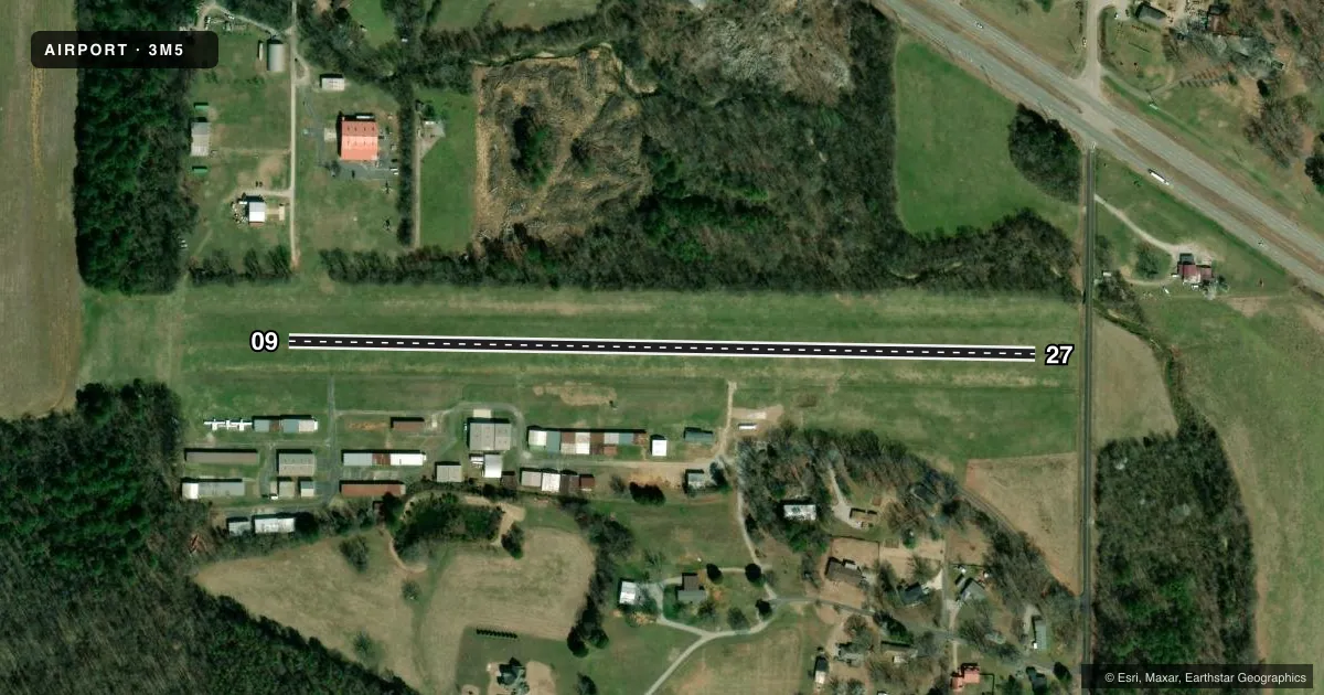
Full pagePattern entry · RWY 09
LEFT TRAFFICAirport sketch
Runways drawn to scale from FAA survey coordinates, rendered over satellite imagery. Not for navigation.
Approaches & charts
Services on the field
Fuel grades, oxygen, maintenance, ramp storage and lighting — as declared to the FAA by the airport operator.
Fuel & services
- Fuel
- 100LL
- Oxygen (bottled)
- Not available
- Oxygen (bulk)
- Not available
- Airframe repair
- Minor
- Power plant repair
- Minor
- Other services
- GLD,INSTR,RNTL,TOW
Ramp & ground
- Transient storage
- Tie-down
- Landing fee
- No fee published
- Customs
- Not available
- Lighting schedule
- SEE RMK
- Beacon schedule
- SEE RMK
- Beacon
- White / Green (civil land)(WG)
- Wind indicator
- Lighted
- Segmented circle
- No
Fuel & FBOs
Cheapest 100LL and Jet A on the field and nearby. Always confirm with the FBO before taxi.
Airport notes
Surface conditions, obstructions, local procedures, lighting outages and other notes published with each FAA cycle.
General notes
- TWY LGTS FOR TWY TURNOFF ONLY.
- FOR CD CTC HUNTSVILLE APCH AT 256-542-2070, WHEN APCH CLSD CTC MEMPHIS ARTCC AT 901-368-8453/8449.
- GLIDER ACT INVOF ARPT.
- ARPT MOWING IN PROGRESS WKDAYS SPRING THRU AUTUMN.
- DEER ON AND INVOF OF ARPT
Lighting notes
- ACTVT ROTG BCN - CTAF.
- ACTVT LIRL RWY 09/27 - CTAF.
VFR map & nearby airports
VFR sectional. Tap any ICAO chip to open that airport.
Key facts · 3M5
Answer card- ICAO
- 3M5
- Name
- MOONTOWN
- Location
- HUNTSVILLE, ALABAMA
- Elevation
- 655 ft MSL
- Traffic pattern altitude
- 1,655 ft MSL (1,000 AGL)
- Control tower
- Non-towered (use CTAF)
- Total runways
- 1
- Longest runway
- 09/27 · 2,180 ft
- Published ILS approaches
- 0
- Published frequencies
- 3
- Magnetic variation
- 1°
- Current flight rules
- VFR
- Current wind
- Calm / unavailable
- Favored runway now
- –
Moontown Airport sits near Huntsville, Alabama. Field elevation is 655 ft MSL. The airport has one runway. Runway 09/27 is 2,180 ft of turf, so plan for short-field performance and soft-field technique. The field is non-towered. CTAF and UNICOM are both 122.7. Huntsville Approach is 125.6 for approach and departure work. No ILS approaches are published here.
Pattern altitude is not published. Use the standard 1,000 ft AGL pattern unless the current Chart Supplement says otherwise. That puts the light-piston pattern at about 1,655 ft MSL. The on-field FBO is Moontown Airport. It carries 100LL. Call (256) 852-9781 before arrival if you need current service details.
A few published remarks matter here. The rotating beacon is activated by CTAF. The low-intensity runway lights on 09/27 are also CTAF-activated. Taxiway lights are for turnoff use only. Deer are reported on and near the airport. Glider activity is also in the area. Mowing runs on weekdays from spring through autumn, so expect changing surface conditions and possible field work. If you need clearance delivery, contact Huntsville Approach. If Approach is closed, use Memphis ARTCC. Check the current Chart Supplement before flying in for any updated procedures or restrictions.