METAR & TAF 5M0
5M0 does not publish a METAR.
Showing the nearest reporting station: KCMD (CULLMAN RGNL/FOLSOM FLD) · 9.2 NM away. Conditions at 5M0 may differ.
METAR · KCMD
Observed 12:15Z
KCMD 271215Z AUTO 17004KT 10SM CLR 23/23 A2997 RMK AO2 LTG DSNT SE AND S
- Wind
- 170° @ 4 kt
- Visibility
- 10 SM
- Temp / Dew
- 23°C / 23°C
- Altimeter
- 29.97 inHg
- Clouds
- CLR
- Density alt
- 1,677 ft
- Ceiling
- Unlimited
- Rules
- VFR
Airport info & contacts
Manager on record, flight service, ARTCC, attendance schedule and pattern altitude — published by the FAA and refreshed every 28 days.
Location
- From city
- 2 NM S
- VFR sectional
- ATLANTA
- ARTCC
- ZME · MEMPHIS
- NOTAM facility
- ANB (NOTAM-D)
Airport manager
- Name
- STONEY POWELL
- Phone
- 256-773-1130
- Address
- 450 AIRPORT RD SW, HARTSELLE AL 35640
Flight service · Hours
- FSS ANB
- ANNISTON1-800-WX-BRIEF
- Attendance
- 0800-1700
Frequencies
Tap any row to copy the frequency to your clipboard.
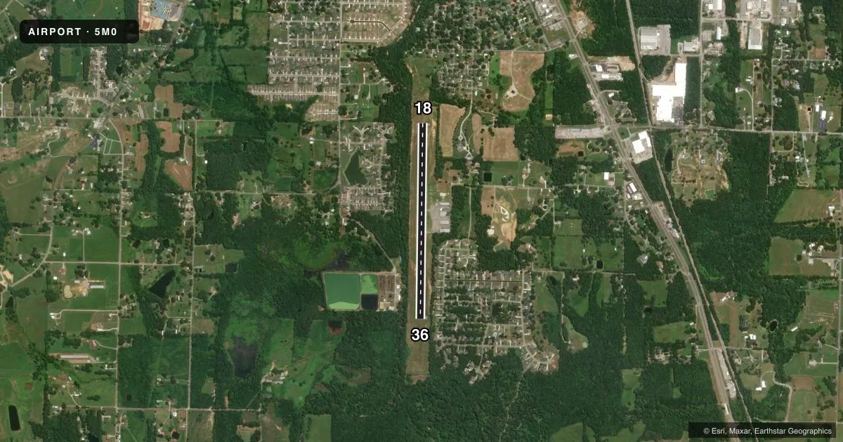
Runways & pattern
Full pagePattern entry · RWY 18
LEFT TRAFFICRunway end performance
| End | TORA | TODA | ASDA | LDA | VGSI | Approach lights | Obstruction |
|---|---|---|---|---|---|---|---|
| 18 | — | — | — | — | — | — | 26', tree, 312' from thr, 138' R of cntrln, slope 4 |
| 36 | — | — | — | — | VASI 2-box left(3°) | — | 79', tree, 1249' from thr, 151' R of cntrln, slope 13 |
Declared distances in feet. TORA = takeoff run available, TODA = takeoff distance, ASDA = accelerate-stop, LDA = landing distance.
Airport sketch
Runways drawn to scale from FAA survey coordinates, rendered over satellite imagery. Not for navigation.
Approaches & charts
Services on the field
Fuel grades, oxygen, maintenance, ramp storage and lighting — as declared to the FAA by the airport operator.
Fuel & services
- Fuel
- 100LL
- Oxygen (bottled)
- Not available
- Oxygen (bulk)
- Not available
- Airframe repair
- Major
- Power plant repair
- Major
- Other services
- INSTR,RNTL
Ramp & ground
- Transient storage
- Tie-down
- Hangar
- Landing fee
- No fee published
- Customs
- Not available
- Lighting schedule
- SEE RMK
- Beacon schedule
- SS-SR
- Beacon
- White / Green (civil land)(WG)
- Wind indicator
- Lighted
- Segmented circle
- Yes
Fuel & FBOs
Cheapest 100LL and Jet A on the field and nearby. Always confirm with the FBO before taxi.
Airport notes
Surface conditions, obstructions, local procedures, lighting outages and other notes published with each FAA cycle.
General notes
- FOR CD CTC HUNTSVILLE APCH AT 256-542-2070, WHEN APCH CLSD CTC MEMPHIS ARTCC AT 901-368-8453/8449.
Lighting notes
- ACTVT MIRL RY 18/36 & VASI RY 36 - CTAF. MIRL RY 18/36 PRESET HIGH INTST.
Approach & departure obstructions
- 18ALL MKNGS OBSCD OR FADED
- 36ALL MKNGS OBSCD OR FADED
Other notes
- MANAGERAFT HRS 256-303-2777.
VFR map & nearby airports
VFR sectional. Tap any ICAO chip to open that airport.
Key facts · 5M0
Answer card- ICAO
- 5M0
- Name
- HARTSELLE/MORGAN COUNTY RGNL
- Location
- HARTSELLE, ALABAMA
- Elevation
- 628.5 ft MSL
- Traffic pattern altitude
- 1,628.5 ft MSL (1,000 AGL)
- Control tower
- Non-towered (use CTAF)
- Total runways
- 1
- Longest runway
- 18/36 · 3,599 ft
- Published ILS approaches
- 0
- Published frequencies
- 4
- Magnetic variation
- 3°
- Current flight rules
- VFR
- Current wind
- 170° at 4 kt
- Favored runway now
- RWY 18
Hartselle/Morgan County Rgnl sits in Hartselle, Alabama. Field elevation is 628.5 ft MSL. The airport has one runway. Runway 18/36 is 3,599 ft long with asphalt pavement. This is an uncontrolled field. CTAF and UNICOM are both 122.8. There is no tower.
No ILS approaches are published here. The published pattern altitude is not listed, so use the standard 1,000 ft AGL for light piston traffic unless the current Chart Supplement says otherwise. The runway lights on 18/36 are medium intensity. Runway 36 also has a visual approach slope indicator on the CTAF. Published remarks say runway markings on both ends are obscured or faded. That is worth planning for on rollout and lineup.
Blackstone Rotor is on the field. It carries 100LL. For clearance delivery, Huntsville Approach is listed in the remarks. If Huntsville Approach is closed, the remarks direct pilots to Memphis ARTCC. After hours contact is also published in the remarks. For a first visit, brief the faded runway markings, the single-runway setup and the lack of published ILS before you go in.