METAR & TAF 2A8
2A8 does not publish a METAR.
Showing the nearest reporting station: KCMD (CULLMAN RGNL/FOLSOM FLD) · 15.2 NM away. Conditions at 2A8 may differ.
METAR · KCMD
Observed 11:55Z
KCMD 271155Z AUTO VRB03KT 10SM -RA CLR 23/23 A2996 RMK AO2 LTG DSNT SE AND S P0003
- Wind
- VAR @ 3 kt
- Visibility
- 10 SM
- Temp / Dew
- 23°C / 23°C
- Altimeter
- 29.96 inHg
- Clouds
- CLR
- Density alt
- 1,885 ft
- Ceiling
- Unlimited
- Rules
- VFR
Airport info & contacts
Manager on record, flight service, ARTCC, attendance schedule and pattern altitude — published by the FAA and refreshed every 28 days.
Location
- From city
- 1 NM NE
- VFR sectional
- ATLANTA
- ARTCC
- ZME · MEMPHIS
- NOTAM facility
- ANB (NOTAM-D)
Airport manager
- Name
- RANDALL WISENER
- Phone
- 907-312-4240
- Address
- 1315 SARDIS AIRPORT ROAD, ADDISON AL 35540
Flight service · Hours
- FSS ANB
- ANNISTON1-800-WX-BRIEF
- Attendance
- Unattended
Frequencies
Tap any row to copy the frequency to your clipboard.
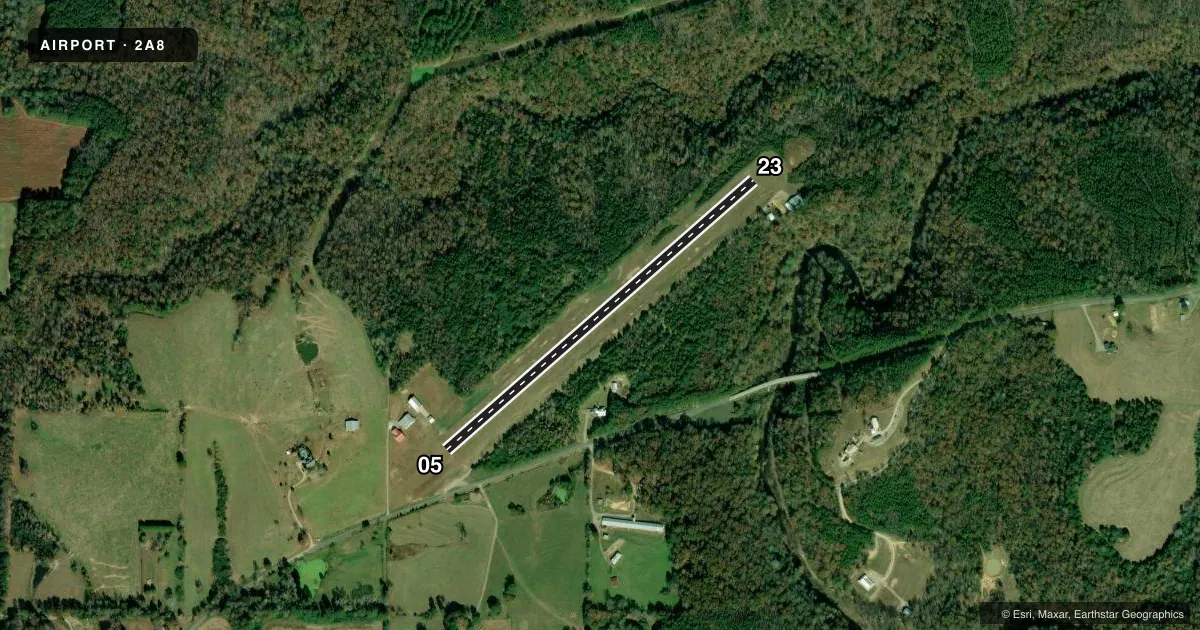
Runways & pattern
Full pagePattern entry · RWY 05
LEFT TRAFFICRunway end performance
| End | TORA | TODA | ASDA | LDA | VGSI | Approach lights | Obstruction |
|---|---|---|---|---|---|---|---|
| 05 | — | — | — | — | — | — | 25', trees, 629' from thr, 25' R of cntrln, slope 25 |
| 23 | — | — | — | — | — | — | 30', trees, 454' from thr, 178' R of cntrln, slope 15 |
Declared distances in feet. TORA = takeoff run available, TODA = takeoff distance, ASDA = accelerate-stop, LDA = landing distance.
Airport sketch
Runways drawn to scale from FAA survey coordinates, rendered over satellite imagery. Not for navigation.
Approaches & charts
Services on the field
Fuel grades, oxygen, maintenance, ramp storage and lighting — as declared to the FAA by the airport operator.
Fuel & services
- Fuel
- Not available
Ramp & ground
- Transient storage
- Not published
- Wind indicator
- Yes
- Segmented circle
- No
Fuel & FBOs
Cheapest 100LL and Jet A on the field and nearby. Always confirm with the FBO before taxi.
Airport notes
Surface conditions, obstructions, local procedures, lighting outages and other notes published with each FAA cycle.
General notes
- FOR CD CTC MEMPHIS ARTCC AT 901-368-8453/8449.
- ADDISON ARPT (2A8) IS PRIVATELY OWNED, PRIVATELY OPERATED, PUBLIC USE ARPT. ARPT IS OPEN FOR DAY USE AND VFR OPS ONLY.
Approach & departure obstructions
- 05MKD BY WHITE CONES WITH BLACK TIPS.
- 23MKD BY WHITE CONES WITH BLACK TIPS.
Other notes
- PRVDD VFR USE ONLY.
VFR map & nearby airports
VFR sectional. Tap any ICAO chip to open that airport.
Key facts · 2A8
Answer card- ICAO
- 2A8
- Name
- ADDISON
- Location
- ADDISON, ALABAMA
- Elevation
- 786 ft MSL
- Traffic pattern altitude
- 1,786 ft MSL (1,000 AGL)
- Control tower
- Non-towered (use CTAF)
- Total runways
- 1
- Longest runway
- 05/23 · 2,644 ft
- Published ILS approaches
- 0
- Published frequencies
- 1
- Magnetic variation
- 0°
- Current flight rules
- VFR
- Current wind
- 000° at 3 kt
- Favored runway now
- RWY 05
Addison Muni is in Addison, Alabama. The field elevation is 786 ft MSL. It has one runway, 05/23 and the longest runway is 2,644 ft of turf. The airport is not towered. CTAF is 122.9.
No ILS approaches are published here. The airport is open for day use and VFR operations only. The published remarks also say the runway ends are marked by white cones with black tips. That is worth a close look on short final, especially on a turf strip.
Pattern altitude is not published in the facts. Use the standard 1,000 ft AGL for light piston traffic unless the current FAA Chart Supplement says otherwise. For clearance delivery, contact Memphis ARTCC at 901-368-8453 or 901-368-8449. There are no on-field FBOs listed in the facts. Plan to verify services directly with the airport operator before arrival.
This is a small non-towered field with VFR-only use. A first-time pilot should brief the turf surface, the short runway length and the lack of published instrument approaches before going in. Check the current FAA Chart Supplement for any changes before you fly.