METAR & TAF M22
M22 does not publish a METAR.
Showing the nearest reporting station: KMSL (NORTHWEST ALABAMA RGNL) · 18.7 NM away. Conditions at M22 may differ.
METAR · KMSL
Observed 05:53Z
KMSL 270553Z AUTO 00000KT 10SM FEW017 FEW080 27/24 A2991 RMK AO2 LTG DSNT NE AND E PRESFR SLP119 T02670239 10322 20267 403440233 58016
- Wind
- 000° @ 0 kt
- Visibility
- 10 SM
- Temp / Dew
- 27°C / 24°C
- Altimeter
- 29.91 inHg
- Clouds
- FEW
- Density alt
- 2,342 ft
- Ceiling
- Unlimited
- Rules
- VFR
Airport info & contacts
Manager on record, flight service, ARTCC, attendance schedule and pattern altitude — published by the FAA and refreshed every 28 days.
Location
- From city
- 3 NM SE
- VFR sectional
- ATLANTA
- ARTCC
- ZME · MEMPHIS
- NOTAM facility
- ANB (NOTAM-D)
Airport manager
- Name
- EMILY EVANS
- Phone
- 256-412-5225
- Address
- 13365 HWY 243, RUSSELLVILLE AL 35654-7605
Flight service · Hours
- FSS ANB
- ANNISTON1-800-WX-BRIEF
- Attendance
- MON-SAT · 0900-1700
Frequencies
Tap any row to copy the frequency to your clipboard.
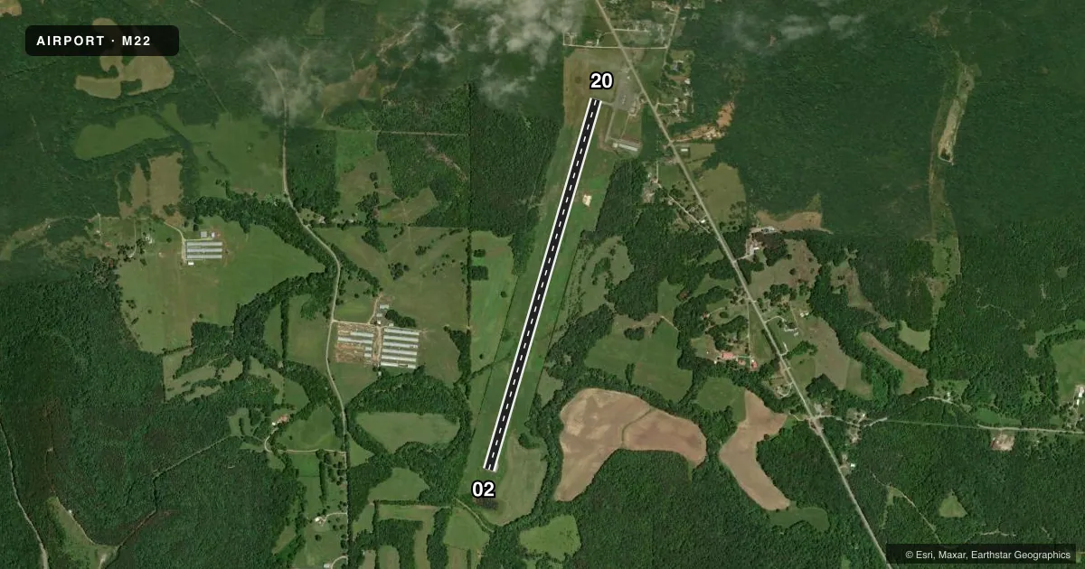
Runways & pattern
Full pagePattern entry · RWY 02
LEFT TRAFFICRunway end performance
| End | TORA | TODA | ASDA | LDA | VGSI | Approach lights | Obstruction |
|---|---|---|---|---|---|---|---|
| 02 | 5,000' | 5,000' | 5,500' | 5,500' | PAPI 2-box left(4°) | — | 20', trees, 469' from thr, 117' R of cntrln, slope 13 |
| 20 | 5,500' | 5,500' | 5,500' | 5,000' | PAPI 4-box left(3°) | — | — |
Declared distances in feet. TORA = takeoff run available, TODA = takeoff distance, ASDA = accelerate-stop, LDA = landing distance.
Airport sketch
Runways drawn to scale from FAA survey coordinates, rendered over satellite imagery. Not for navigation.
Approaches & charts
Services on the field
Fuel grades, oxygen, maintenance, ramp storage and lighting — as declared to the FAA by the airport operator.
Fuel & services
- Fuel
- 100LLA
- Oxygen (bottled)
- Not available
- Oxygen (bulk)
- Not available
- Airframe repair
- Not available
- Power plant repair
- Not available
- Other services
- INSTR,RNTL
Ramp & ground
- Transient storage
- Tie-down
- Landing fee
- No fee published
- Customs
- Not available
- Lighting schedule
- SEE RMK
- Beacon schedule
- SS-SR
- Beacon
- White / Green (civil land)(WG)
- Wind indicator
- Lighted
- Segmented circle
- Yes
Fuel & FBOs
Cheapest 100LL and Jet A on the field and nearby. Always confirm with the FBO before taxi.
Airport notes
Surface conditions, obstructions, local procedures, lighting outages and other notes published with each FAA cycle.
General notes
- FOR CD CTC MEMPHIS ARTCC AT 901-368-8453/8449.
Lighting notes
- ACTVT REIL RWY 02 & 20; PAPI RWY 02 & 20; MIRL RWY 02/20 - CTAF.
Runway surface & condition
- 02/20PCR VALUE: 903/F/C/X/T
Approach & departure obstructions
- 20APCH SLP 29:1 TO DTHR.
Other notes
- VFR OPS ONLY.
- 1AFT HRS CALL 256-710-4739.
- MANAGERARPT NR 256-331-9000.
VFR map & nearby airports
VFR sectional. Tap any ICAO chip to open that airport.
Key facts · M22
Answer card- ICAO
- M22
- Name
- BILL PUGH FLD
- Location
- RUSSELLVILLE, ALABAMA
- Elevation
- 717.8 ft MSL
- Traffic pattern altitude
- 1,717.8 ft MSL (1,000 AGL)
- Control tower
- Non-towered (use CTAF)
- Total runways
- 1
- Longest runway
- 02/20 · 5,500 ft
- Published ILS approaches
- 0
- Published frequencies
- 2
- Magnetic variation
- 2°
- Current flight rules
- VFR
- Current wind
- 000° at 0 kt
- Favored runway now
- –
Bill Pugh Fld is in Russellville, Alabama. The field elevation is 717.8 ft MSL. It has one runway, 02/20, which is 5,500 ft of asphalt. There is no control tower. CTAF and UNICOM are both 122.8. No ILS approaches are published, so plan for VFR only. The published remarks say this is VFR operations only.
Pattern altitude is not published. Use the standard 1,000 ft AGL pattern unless the current Chart Supplement or local procedures say otherwise. For a first-time arrival, note the lighting setup. Runway end identifier lights are active on 02 and 20. Medium intensity runway lights are on both ends and are controlled by CTAF. PAPI is available on runway 20. The runway 20 approach also has a published slope note to the displaced threshold, so brief that side carefully before you descend.
Explore Aviation is on the field. It carries 100LL and Jet A. The airport manager phone number is 256-331-9000. After hours, call 256-710-4739. For clearance delivery, contact Memphis ARTCC at 901-368-8453 or 901-368-8449. The pavement rating is published as 903/F/C/X/T. Check the current Chart Supplement for any local operating notes before you go.