METAR & TAF KHAB
KHAB does not publish a METAR.
Showing the nearest reporting station: KJFX (WALKER COUNTY/BEVILL FLD) · 36.4 NM away. Conditions at KHAB may differ.
METAR · KJFX
Observed 12:55Z
KJFX 271255Z AUTO VRB03KT 10SM CLR 24/24 A2996 RMK AO2 P0003
- Wind
- VAR @ 3 kt
- Visibility
- 10 SM
- Temp / Dew
- 24°C / 24°C
- Altimeter
- 29.96 inHg
- Clouds
- CLR
- Density alt
- 1,571 ft
- Ceiling
- Unlimited
- Rules
- VFR
Airport info & contacts
Manager on record, flight service, ARTCC, attendance schedule and pattern altitude — published by the FAA and refreshed every 28 days.
Location
- From city
- 1 NM S
- VFR sectional
- ATLANTA
- ARTCC
- ZME · MEMPHIS
- NOTAM facility
- ANB (NOTAM-D)
Airport manager
- Name
- JEFF DAVIS
- Phone
- 205-921-9585
- Address
- 550 DR. PYLE DRIVE, HAMILTON AL 35570
Flight service · Hours
- FSS ANB
- ANNISTON1-800-WX-BRIEF
- Attendance
- MON-FRI · 0800-1630
Frequencies
Tap any row to copy the frequency to your clipboard.
Runways & pattern
Full pagePattern entry · RWY 36
LEFT TRAFFICRunway end performance
| End | TORA | TODA | ASDA | LDA | VGSI | Approach lights | Obstruction |
|---|---|---|---|---|---|---|---|
| 18 | — | — | — | — | PAPI 2-box left(3°) | — | 45', tree, 740' from thr, 214' R of cntrln, slope 12 |
| 36 | — | — | — | — | PAPI 2-box left(3°) | — | 32', tree, 677' from thr, 162' R of cntrln, slope 14 |
Declared distances in feet. TORA = takeoff run available, TODA = takeoff distance, ASDA = accelerate-stop, LDA = landing distance.
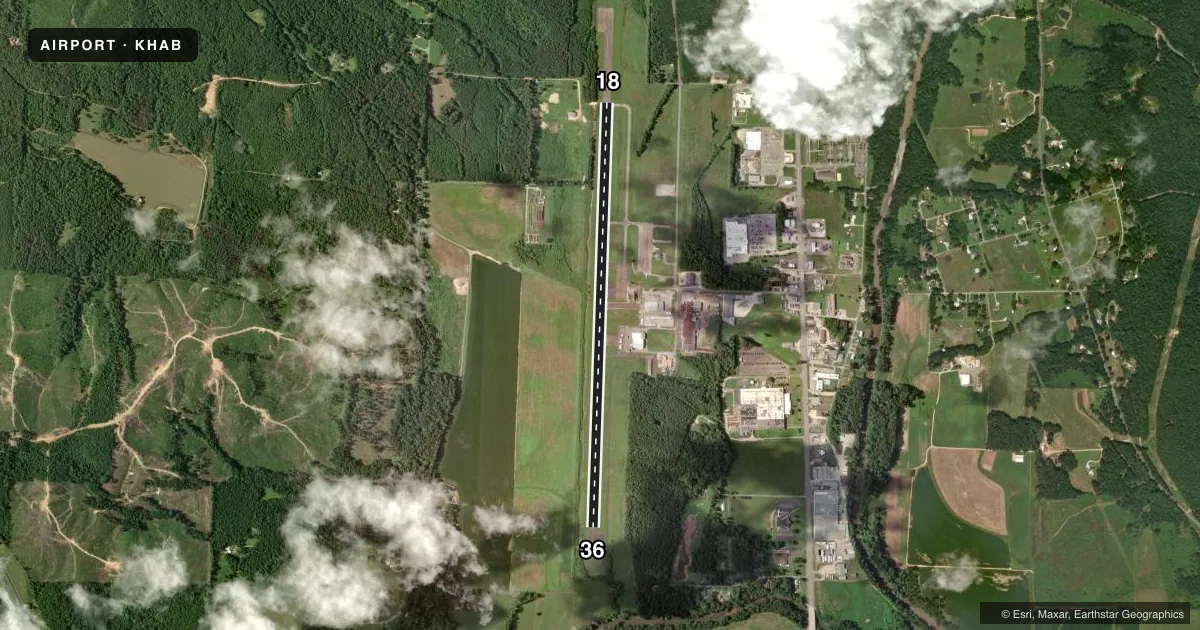
Airport sketch
Runways drawn to scale from FAA survey coordinates, rendered over satellite imagery. Not for navigation.
Approaches & charts
Services on the field
Fuel grades, oxygen, maintenance, ramp storage and lighting — as declared to the FAA by the airport operator.
Fuel & services
- Fuel
- 100LLA+
- Oxygen (bottled)
- Not available
- Oxygen (bulk)
- Not available
- Airframe repair
- Not available
- Power plant repair
- Not available
Ramp & ground
- Transient storage
- Tie-down
- Hangar
- Landing fee
- No fee published
- Customs
- Not available
- Lighting schedule
- SEE RMK
- Beacon schedule
- SS-SR
- Beacon
- White / Green (civil land)(WG)
- Wind indicator
- Lighted
- Segmented circle
- Yes
Fuel & FBOs
Cheapest 100LL and Jet A on the field and nearby. Always confirm with the FBO before taxi.
Airport notes
Surface conditions, obstructions, local procedures, lighting outages and other notes published with each FAA cycle.
General notes
- FOR CD CTC MEMPHIS ARTCC AT 901-368-8453/8449.
Lighting notes
- REIL RWY 18 & 36; PAPI RWY 18 & 36; MIRL RWY 18/36 OPER DUSK - 2100; AFT 2100-CTAF.
Approach & departure obstructions
- 18ALL RWY MKINGS SVRLY FADED
- 36ALL RWY MKINGS SVRLY FADED
Other notes
- BEFORE FAA ACT.
- 1FOR SVC AFT HRS 205-570-1677
VFR map & nearby airports
VFR sectional. Tap any ICAO chip to open that airport.
Key facts · KHAB
Answer card- ICAO
- KHAB
- Name
- MARION COUNTY-RANKIN FITE
- Location
- HAMILTON, ALABAMA
- Elevation
- 436 ft MSL
- Traffic pattern altitude
- 1,436 ft MSL (1,000 AGL)
- Control tower
- Non-towered (use CTAF)
- Total runways
- 1
- Longest runway
- 18/36 · 5,495 ft
- Published ILS approaches
- 0
- Published frequencies
- 2
- Magnetic variation
- 1°
- Current flight rules
- VFR
- Current wind
- 000° at 3 kt
- Favored runway now
- RWY 36
Marion County-Rankin Fite Airport (KHAB) sits in Hamilton, Alabama at 436 ft MSL. It has one runway, 18/36, which is 5,495 ft long. The airport is non-towered. CTAF and UNICOM are both 122.8. No ILS approaches are published here.
The pattern altitude is not published. Use 1,000 ft AGL for light piston operations unless the current Chart Supplement says otherwise. The field has runway end identifier lights and PAPI on both ends of runway 18/36. Medium intensity runway lights on 18/36 operate from dusk to 2100. After 2100, use CTAF for lighting activation guidance. Runway markings on both ends are reported as severely faded, so plan to read the pavement carefully on arrival and departure.
Marion County-Rankin Fite Airport is the on-field FBO. It carries 100LL and Jet A Prist. For after-hours service, call 205-570-1677. For clearance delivery, Memphis ARTCC is listed at 901-368-8453 or 901-368-8449. First-time visitors should verify current runway condition and lighting status before a night arrival. Check the current FAA Chart Supplement for any updated remarks before you go.