METAR & TAF KMSL
Current METAR
Observed 04:53Z
KMSL 270453Z AUTO 00000KT 10SM CLR 27/26 A2997 RMK AO2 LTG DSNT N SLP140 T02670261
- Wind
- 000° @ 0 kt
- Visibility
- 10 SM
- Temp / Dew
- 27°C / 26°C
- Altimeter
- 29.97 inHg
- Clouds
- CLR
- Density alt
- 2,061 ft
- Ceiling
- Unlimited
- Rules
- VFR
Airport info & contacts
Manager on record, flight service, ARTCC, attendance schedule and pattern altitude — published by the FAA and refreshed every 28 days.
Location
- From city
- 1 NM E
- VFR sectional
- ATLANTA
- ARTCC
- ZME · MEMPHIS
- NOTAM facility
- MSL (NOTAM-D)
Airport manager
- Name
- BARRY GRIFFITH
- Phone
- 256-383-2270
- Address
- 1729 T. ED CAMPBELL DR SUITE A, MUSCLE SHOALS AL 35661-2016
Flight service · Hours
- FSS ANB
- ANNISTON1-800-WX-BRIEF
- Attendance
- 0600-1800
Frequencies
Tap any row to copy the frequency to your clipboard.
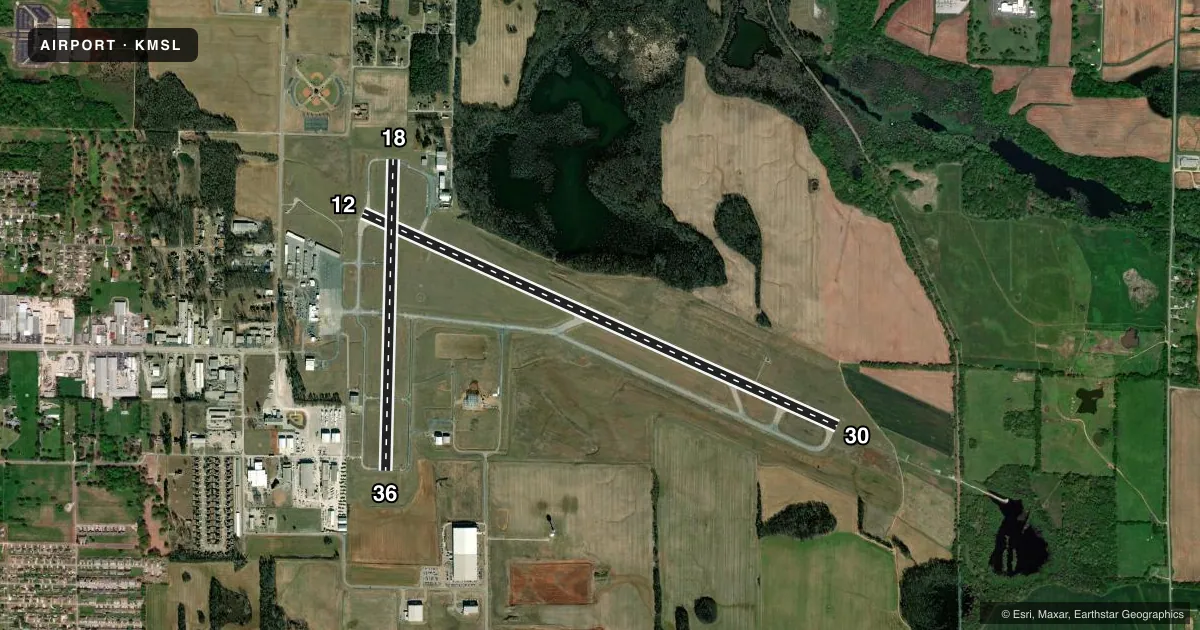
Runways & pattern
Full pagePattern entry · RWY 12
LEFT TRAFFIC| Runway | Heading (°M) | Length | Surface | Traffic |
|---|---|---|---|---|
| 12/30 | 111° / 291° | 6,694 ft | ASPH | Standard L |
| 18/36 | 178° / 358° | 4,000 ft | ASPH | Standard L |
Runway end performance
| End | TORA | TODA | ASDA | LDA | VGSI | Approach lights | Obstruction |
|---|---|---|---|---|---|---|---|
| 12 | — | — | — | — | PAPI 4-box right(3°) | — | 52', trees, 1689' from thr, 269' R of cntrln, slope 28 |
| 30 | — | — | — | — | — | MALSR | 68', trees, 2004' from thr, 530' R of cntrln, slope 26 |
| 18 | — | — | — | — | PAPI 4-box left(3°) | — | 61', tree, 906' from thr, 283' R of cntrln, slope 11 |
| 36 | — | — | — | — | PAPI 4-box left(3°) | — | — |
Declared distances in feet. TORA = takeoff run available, TODA = takeoff distance, ASDA = accelerate-stop, LDA = landing distance.
Airport sketch
Runways drawn to scale from FAA survey coordinates, rendered over satellite imagery. Not for navigation.
Approaches & charts
ILS · 1
Services on the field
Fuel grades, oxygen, maintenance, ramp storage and lighting — as declared to the FAA by the airport operator.
Fuel & services
- Fuel
- 100LLA
- Oxygen (bottled)
- Not available
- Oxygen (bulk)
- Not available
- Airframe repair
- Not available
- Power plant repair
- Not available
- Other services
- AFRT,INSTR,RNTL
Ramp & ground
- Transient storage
- Tie-down
- Hangar
- Landing fee
- No fee published
- Customs
- Not available
- Lighting schedule
- SEE RMK
- Beacon schedule
- SS-SR
- Beacon
- White / Green (civil land)(WG)
- Wind indicator
- Lighted
- Segmented circle
- Yes
Fuel & FBOs
Cheapest 100LL and Jet A on the field and nearby. Always confirm with the FBO before taxi.
Airport notes
Surface conditions, obstructions, local procedures, lighting outages and other notes published with each FAA cycle.
General notes
- NO GA PARKING ON ACR RAMP.
- LNDG FEE & PAX FAC CHRG FOR UNSKED ACR & CHTR OPNS.
- TWY A IS THE PREF TWY FOR ACR & CHTR OPNS USING THE ACR RAMP.
- LNDG FEE FOR ACR OVER 12,500 LBS.
- GCO AVBL ON FREQ 121.725 FOR MEMPHIS ARTCC (ZME).
- FOR CD IF UNA VIA GCO CTC MEMPHIS ARTCC AT 901-368-8453/8449.
Lighting notes
- ACTVT MALSR RWY 30; REIL RWY 12; PAPI RWY 12; PAPI RWY 18 & 36; HIRL RWY 12/30; MIRL RWY 18/36 - CTAF.
Fuel notes
- 100LLFUEL AVBL NIGHTS CALL 256-383-2270. AVGAS 100LL SELF SERVE AVBL 24 HRS.
Runway surface & condition
- 12/30PCR VALUE: 430/F/B/X/T
- 18/36PCR VALUE: 470/F/C/X/T
- 18/36RWY 18/36 NOT AVBL FOR PART 121/PART 380 OPS WITH SKED PAX CARRYING OPS MORE THAN 9 PAX SEATS AND NON-SKED PAX CARRYING OPS MORE THAN 30 PAX SEATS.
Approach & departure obstructions
- 30CALM WIND RWY.
Other notes
- PPR FOR UNSKED ACR & CHTR OPNS WITH MORE THAN 30 PSGR SEATS; CALL AMGR (256) 381-2869, EXT 101 OR FAX (256) 381-2915.
- 1EXC THANKSGIVING, CHRISTMAS, AND NEW YEARS DAY
- MANAGEREXT. 101.
VFR map & nearby airports
VFR sectional. Tap any ICAO chip to open that airport.
Key facts · KMSL
Answer card- ICAO
- KMSL
- Name
- NORTHWEST ALABAMA RGNL
- Location
- MUSCLE SHOALS, ALABAMA
- Elevation
- 550.5 ft MSL
- Traffic pattern altitude
- 1,550.5 ft MSL (1,000 AGL)
- Control tower
- Non-towered (use CTAF)
- Total runways
- 2
- Longest runway
- 12/30 · 6,694 ft
- Published ILS approaches
- 1
- Published frequencies
- 2
- Magnetic variation
- 3°
- Current flight rules
- VFR
- Current wind
- 000° at 0 kt
- Favored runway now
- –
Northwest Alabama Rgnl is in Muscle Shoals, Alabama. Field elevation is 550.5 ft MSL. The airport has two asphalt runways. The longest is 12/30 at 6,694 ft. There is no control tower, so use CTAF 123.05 for local traffic. One ILS approach is published for runway 30.
Pattern altitude is not published. Use 1,000 ft AGL for light piston traffic unless the current Chart Supplement says otherwise. That puts the standard pattern near 1,550.5 ft MSL here. Shoals Flight Center is on the field. It carries 100LL and Jet A Prist. 100LL self-serve is available 24 hours. Fuel is also available at night by calling the FBO.
A few operational notes matter here. No general aviation parking is allowed on the aircraft ramp. Taxiway A is the preferred taxiway for aircraft and charter operations using the aircraft ramp. Landing fees apply for aircraft over 12,500 pounds. Unscheduled aircraft and charter operations with more than 30 passenger seats need prior permission. If you are planning a nonstandard arrival, or if you need clearance delivery and ground comms are not available, contact Memphis ARTCC using the number in the Chart Supplement. Check the current Chart Supplement for any published noise or curfew restrictions before flying into the field.