METAR & TAF 2M2
Current METAR
Observed 12:55Z
K2M2 271255Z AUTO 22004KT 10SM FEW110 22/21 A2992 RMK A01
- Wind
- 220° @ 4 kt
- Visibility
- 10 SM
- Temp / Dew
- 22°C / 21°C
- Altimeter
- 29.92 inHg
- Clouds
- FEW
- Density alt
- 2,001 ft
- Ceiling
- Unlimited
- Rules
- VFR
Airport info & contacts
Manager on record, flight service, ARTCC, attendance schedule and pattern altitude — published by the FAA and refreshed every 28 days.
Location
- From city
- 3 NM NE
- VFR sectional
- ATLANTA
- ARTCC
- ZME · MEMPHIS
- NOTAM facility
- MKL (NOTAM-D)
Airport manager
- Name
- DOUG SMITH
- Phone
- 931-762-5133
- Address
- 4110 AIRPORT DR, LAWRENCEBURG TN 38464
Flight service · Hours
- FSS MKL
- JACKSON1-800-WX-BRIEF
- Attendance
- 0800-1700
Frequencies
Tap any row to copy the frequency to your clipboard.
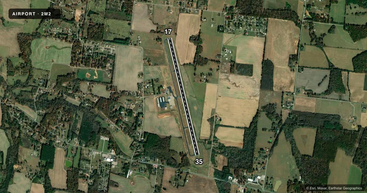
Runways & pattern
Full pagePattern entry · RWY 17
LEFT TRAFFICRunway end performance
| End | TORA | TODA | ASDA | LDA | VGSI | Approach lights | Obstruction |
|---|---|---|---|---|---|---|---|
| 17 | — | — | — | — | PAPI 4-box left(3°) | — | 58', trees, 1730' from thr, 379' R of cntrln, slope 26 |
| 35 | — | — | — | — | PAPI 4-box left(3°) | — | 98', trees, 2743' from thr, 609' R of cntrln, slope 25 |
Declared distances in feet. TORA = takeoff run available, TODA = takeoff distance, ASDA = accelerate-stop, LDA = landing distance.
Airport sketch
Runways drawn to scale from FAA survey coordinates, rendered over satellite imagery. Not for navigation.
Approaches & charts
Services on the field
Fuel grades, oxygen, maintenance, ramp storage and lighting — as declared to the FAA by the airport operator.
Fuel & services
- Fuel
- 100LLA+
- Oxygen (bottled)
- Low pressure
- Airframe repair
- Major
- Power plant repair
- Minor
- Other services
- AGRI,INSTR
Ramp & ground
- Transient storage
- Tie-down
- Hangar
- Landing fee
- No fee published
- Customs
- Not available
- Lighting schedule
- SS-SR
- Beacon schedule
- SS-SR
- Beacon
- White / Green (civil land)(WG)
- Wind indicator
- Lighted
- Segmented circle
- Yes
Fuel & FBOs
Cheapest 100LL and Jet A on the field and nearby. Always confirm with the FBO before taxi.
Airport notes
Surface conditions, obstructions, local procedures, lighting outages and other notes published with each FAA cycle.
General notes
- FOR CD CTC MEMPHIS ARTCC AT 901-368-8453/8449.
Other notes
- BOTH ON SITE
- 1AFT HR - 931-231-4075.
- OWNER931-766-4128.
VFR map & nearby airports
VFR sectional. Tap any ICAO chip to open that airport.
Key facts · 2M2
Answer card- ICAO
- 2M2
- Name
- LAWRENCEBURG/LAWRENCE COUNTY (FLEEMAN FLD)
- Location
- LAWRENCEBURG, TENNESSEE
- Elevation
- 936.5 ft MSL
- Traffic pattern altitude
- 1,936.5 ft MSL (1,000 AGL)
- Control tower
- Non-towered (use CTAF)
- Total runways
- 1
- Longest runway
- 17/35 · 5,002 ft
- Published ILS approaches
- 0
- Published frequencies
- 2
- Magnetic variation
- 1°
- Current flight rules
- VFR
- Current wind
- 220° at 4 kt
- Favored runway now
- RWY 17
Lawrenceburg/Lawrence County Airport sits in Lawrenceburg, Tennessee. The field elevation is 936.5 ft MSL. It has one runway, 17/35, at 5,002 ft. There is no control tower. CTAF and UNICOM are both 122.8.
No ILS approaches are published here. Pattern altitude is not published, so use the standard 1,000 ft AGL for light piston operations unless the current FAA Chart Supplement says otherwise. The on-field FBO is Lawrenceburg/Lawrence County Airport. It carries AVGAS 100LL and Jet A. Airframe and repair services are on site. For clearance delivery, Memphis ARTCC is listed in the remarks. After-hours contact is also published in the Chart Supplement.
For a first-time arrival, the main things to plan for are the non-towered setup and the runway length. The runway is long enough for a lot of light aircraft. You still want to brief the field elevation and local density altitude before departure. Check the current FAA Chart Supplement for any noise or curfew restrictions before flying into the field.