METAR & TAF KBHM
Current METAR
Observed 05:53Z
KBHM 270553Z 24003KT 10SM CLR 28/26 A2999 RMK AO2 SLP144 T02780256 10317 20278 403390239 50001 $
- Wind
- 240° @ 3 kt
- Visibility
- 10 SM
- Temp / Dew
- 28°C / 26°C
- Altimeter
- 29.99 inHg
- Clouds
- CLR
- Density alt
- 2,279 ft
- Ceiling
- Unlimited
- Rules
- VFR
Airport info & contacts
Manager on record, flight service, ARTCC, attendance schedule and pattern altitude — published by the FAA and refreshed every 28 days.
Location
- From city
- 4 NM NE
- VFR sectional
- ATLANTA
- ARTCC
- ZTL · ATLANTA
- NOTAM facility
- BHM (NOTAM-D)
Airport manager
- Name
- RONALD MATHIEU
- Phone
- (205) 599-0505
- Address
- BIRMINGHAM AIRPORT AUTHORITY, 5900 MESSER AIRPORT HWY, BIRMINGHAM AL 35212
Flight service · Hours
- FSS ANB
- ANNISTON1-800-WX-BRIEF
- Attendance
- ALL
Frequencies
Tap any row to copy the frequency to your clipboard.
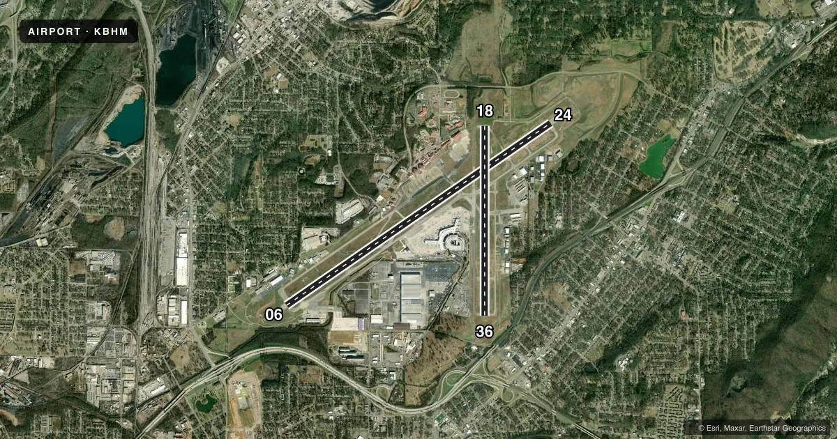
Runways & pattern
Full pagePattern entry · RWY 24
LEFT TRAFFIC| Runway | Heading (°M) | Length | Surface | Traffic |
|---|---|---|---|---|
| 06/24Favored | 52° / 232° | 12,007 ft | ASPH | Standard L |
| 18/36 | 177° / 357° | 7,099 ft | ASPH | Standard L |
Runway end performance
| End | TORA | TODA | ASDA | LDA | VGSI | Approach lights | Obstruction |
|---|---|---|---|---|---|---|---|
| 06 | 12,007' | 12,007' | 12,007' | 12,007' | PAPI 4-box left(3°) | ALSF2 | 58', trees, 1290' from thr, 654' R of cntrln, slope 18 |
| 24 | 12,007' | 12,007' | 12,007' | 10,801' | PAPI 4-box left(3°) | MALSR | 67', gnd, 1323' from thr, 610' R of cntrln, slope 16 |
| 18 | 7,099' | 7,099' | 7,099' | 7,099' | PAPI 4-box left(3.2°) | — | 245', trees, 5689' from thr, 883' R of cntrln, slope 22 |
| 36 | 7,099' | 7,099' | 7,099' | 7,099' | — | — | 62', trees, 1340' from thr, 210' R of cntrln, slope 18 |
Declared distances in feet. TORA = takeoff run available, TODA = takeoff distance, ASDA = accelerate-stop, LDA = landing distance.
Airport sketch
Runways drawn to scale from FAA survey coordinates, rendered over satellite imagery. Not for navigation.
Approaches & charts
ILS · 3
Services on the field
Fuel grades, oxygen, maintenance, ramp storage and lighting — as declared to the FAA by the airport operator.
Fuel & services
- Fuel
- 100LLA
- Oxygen (bottled)
- Not available
- Oxygen (bulk)
- HIGH/LOW
- Airframe repair
- Major
- Power plant repair
- Major
- Other services
- AFRT,AMB,AVNCS,CARGO,CHTR,INSTR,RNTL,SALES,SURV
Ramp & ground
- Transient storage
- Tie-down
- Hangar
- Landing fee
- No fee published
- Customs
- Not available
- Beacon schedule
- SS-SR
- Beacon
- White / Green (civil land)(WG)
- Wind indicator
- Lighted
- Segmented circle
- No
Fuel & FBOs
Cheapest 100LL and Jet A on the field and nearby. Always confirm with the FBO before taxi.
Airport notes
Surface conditions, obstructions, local procedures, lighting outages and other notes published with each FAA cycle.
General notes
- TWY G RSTRD TO ACFT 65000 LBS OR LESS.
- TWY M N OF RWY 6/24 RSTRD TO ACFT 75000 LBS OR LESS.
- TWY N RSTRD TO ACFT 204000 LBS OR LESS.
- BIRD ACTV INVOF RWYS.
- TWY F BTN RWY 18/36 & TWY G RSTRD TO ACFT 100000 LBS OR LESS.
- ANG: PPR RQR FOR ANG RAMP. NML OPR HRS 1300-2330Z++ TUE-FRI, CLSD WKNDS & HOL. NO SVC AVBL OUTSIDE THESE HRS WITHOUT PRIOR APVL. NO LCL OR ROUND-ROBIN FLT BY TRAN ACFT. CALL AIRFIELD OPS DSN 778-2555, C205-714-2555 FOR PPR 72 HR PRIOR (96 HRS FOR CARGO MSN). ALL INBD ACFT CTC ANG COMD POST "VULCN CONTROL" NO LATER THAN 15 MIN PRIOR TO LDG WITH PPR NR AND SUPPORT REQ. SPACE-A CAPABILITIES EXTREMELY LTD, PAX SVC LTD AVAILABILITY.
- TWY H S OF TWY H4 RSTRD TO ACFT WITH WINGSPAN LESS THAN 118 FT.
- TWY A BTN TWY A HLDG BAY AND TWY A3 RSTRD TO ACFT WITH WINGSPAN LESS THAN 150 FT.
- TWY H2 RSTRD TO ACFT WITH WINGSPAN LESS THAN 105 FT.
- TWY H3 RSTRD TO ACFT WITH WINGSPAN LESS THAN 105 FT.
Fuel notes
- AA++100 (MIL)
Runway surface & condition
- 06/24PCR VALUE: 1102/F/D/X/T
- 18/36PCR VALUE: 440/F/D/X/T
Approach & departure obstructions
- 24MALSR ATCT CTLD, OPS UMMONITORED.
- 24NAVAID SHELTER 149 FT FM RWY END, 405 FT L, 1 FT ABV RWY END ELEV.
- 24APCH SLOPE 25:1 DUE TO 44 FT POLE, 4424 FT FROM DSPLCD THR.
VFR map & nearby airports
VFR sectional. Tap any ICAO chip to open that airport.
Key facts · KBHM
Answer card- ICAO
- KBHM
- Name
- BIRMINGHAM-SHUTTLESWORTH INTL
- Location
- BIRMINGHAM, ALABAMA
- Elevation
- 650 ft MSL
- Traffic pattern altitude
- 1,650 ft MSL (1,000 AGL)
- Control tower
- Towered · 24
- Total runways
- 2
- Longest runway
- 06/24 · 12,007 ft
- Published ILS approaches
- 3
- Published frequencies
- 22
- Magnetic variation
- 3°
- Current flight rules
- VFR
- Current wind
- 240° at 3 kt
- Favored runway now
- RWY 24
Birmingham-Shuttlesworth Intl is in Birmingham, Alabama. Field elevation is 650 ft MSL. The airport has 2 asphalt runways. The longest is 12,007 ft on 06/24. The tower is open 24 hours. Three ILS approaches are published for runway ends 06, 18 and 24.
Pattern altitude is not published. Use the standard 1,000 ft AGL for light piston traffic unless ATC gives you something different. That puts the pattern at 1,650 ft MSL based on the field elevation. The field sits under Class C airspace. Expect normal big-airport traffic flow. Stay sharp on taxi instructions.
Atlantic Aviation is on the field. It carries 100LL and Jet A. Million Air is also on the field. It carries 100LL, Jet A and Jet A Prist. The airport remarks also note military A++100 fuel availability.
A few published restrictions matter here. Taxiway M north of runway 06/24 is limited to aircraft 75,000 lb or less. Taxiway N is limited to aircraft 204,000 lb or less. Taxiway F between runway 18/36 and taxiway G is limited to aircraft 100,000 lb or less. Runway 24 has a published obstruction note that drives a 25:1 approach slope. If you are planning a first stop here, check the current Chart Supplement and listen closely to tower and ground. This is a busy controlled field with large-aircraft traffic and specific ramp limits, especially around the Air National Guard area.