METAR & TAF KEKY
Current METAR
Observed 09:56Z
KEKY 270956Z AUTO 00000KT 9SM CLR 25/25 A2995 RMK AO2 LTG DSNT NE SLP112 T02500250 $
- Wind
- 000° @ 0 kt
- Visibility
- 9 SM
- Temp / Dew
- 25°C / 25°C
- Altimeter
- 29.95 inHg
- Clouds
- CLR
- Density alt
- 2,030 ft
- Ceiling
- Unlimited
- Rules
- VFR
Airport info & contacts
Manager on record, flight service, ARTCC, attendance schedule and pattern altitude — published by the FAA and refreshed every 28 days.
Location
- From city
- 3 NM SE
- VFR sectional
- ATLANTA
- ARTCC
- ZTL · ATLANTA
- NOTAM facility
- ANB (NOTAM-D)
Airport manager
- Name
- TIM WASYLUKA
- Phone
- (205) 835-1415
- Address
- 900 MITCHELL FIELD RD, BESSEMER AL 35022
Flight service · Hours
- FSS ANB
- ANNISTON1-800-WX-BRIEF
- Attendance
- 0800-1800
Frequencies
Tap any row to copy the frequency to your clipboard.
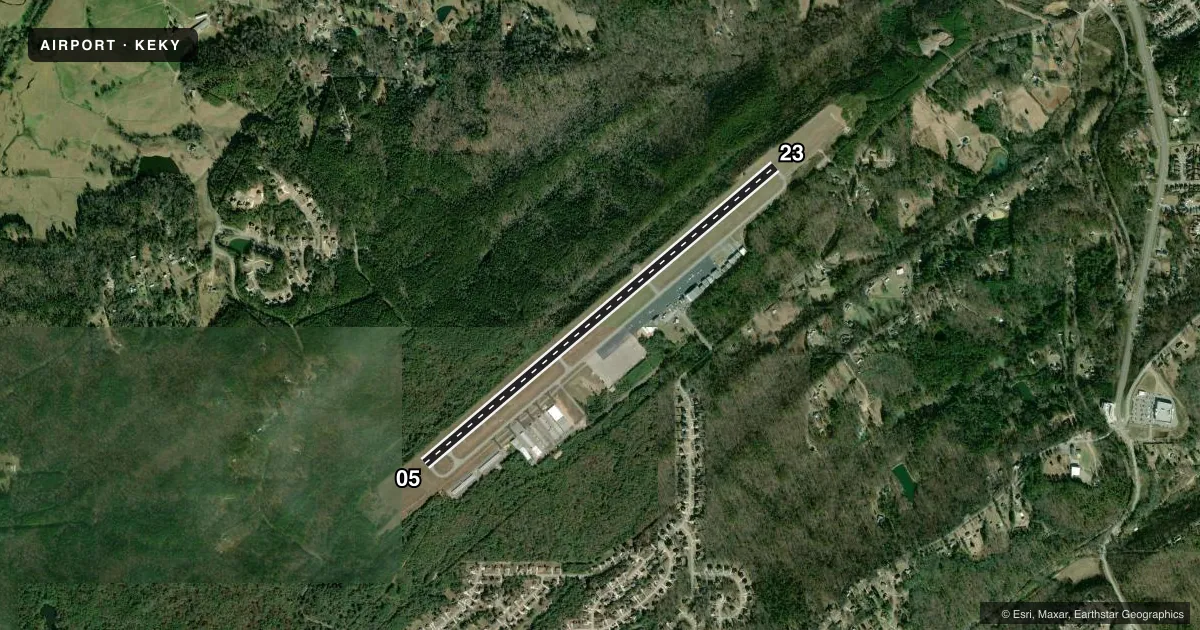
Runways & pattern
Full pagePattern entry · RWY 05
LEFT TRAFFICRunway end performance
| End | TORA | TODA | ASDA | LDA | VGSI | Approach lights | Obstruction |
|---|---|---|---|---|---|---|---|
| 05 | — | — | — | — | PAPI 4-box left(3°) | — | 33', trees, 1136' from thr, 346' R of cntrln, slope 28 |
| 23 | — | — | — | — | PAPI 4-box left(3°) | — | 30', trees, 598' from thr, 167' R of cntrln, slope 13 |
Declared distances in feet. TORA = takeoff run available, TODA = takeoff distance, ASDA = accelerate-stop, LDA = landing distance.
Airport sketch
Runways drawn to scale from FAA survey coordinates, rendered over satellite imagery. Not for navigation.
Approaches & charts
ILS · 1
Services on the field
Fuel grades, oxygen, maintenance, ramp storage and lighting — as declared to the FAA by the airport operator.
Fuel & services
- Fuel
- 100LLAA+
- Oxygen (bottled)
- HIGH/LOW
- Oxygen (bulk)
- Not available
- Airframe repair
- Major
- Power plant repair
- Major
- Other services
- AVNCS,INSTR,RNTL
Ramp & ground
- Transient storage
- Tie-down
- Hangar
- Landing fee
- No fee published
- Customs
- Not available
- Lighting schedule
- SEE RMK
- Beacon schedule
- SS-SR
- Beacon
- White / Green (civil land)(WG)
- Wind indicator
- Lighted
- Segmented circle
- Yes
Fuel & FBOs
Cheapest 100LL and Jet A on the field and nearby. Always confirm with the FBO before taxi.
Airport notes
Surface conditions, obstructions, local procedures, lighting outages and other notes published with each FAA cycle.
General notes
- FOR CD IF UNA VIA FREQ, CTC BIRMINGHAM APCH AT 205-769-3890.
Lighting notes
- ACTVT REIL RWY 05 & 23; HIRL RWY 05/23 - CTAF.
Other notes
- 1FEE FOR AFT HRS SVC CALL 205-835-1415.
VFR map & nearby airports
VFR sectional. Tap any ICAO chip to open that airport.
Key facts · KEKY
Answer card- ICAO
- KEKY
- Name
- BESSEMER NTL
- Location
- BESSEMER, ALABAMA
- Elevation
- 699.6 ft MSL
- Traffic pattern altitude
- 1,699.6 ft MSL (1,000 AGL)
- Control tower
- Non-towered (use CTAF)
- Total runways
- 1
- Longest runway
- 05/23 · 6,007 ft
- Published ILS approaches
- 1
- Published frequencies
- 5
- Magnetic variation
- 3°
- Current flight rules
- VFR
- Current wind
- 000° at 0 kt
- Favored runway now
- –
Bessemer Ntl sits in Bessemer, Alabama, southwest of Birmingham. Field elevation is 699.6 ft MSL. The airport has one runway, 05/23, which is 6,007 ft long. There is no control tower. CTAF and UNICOM are both 123.0. The field has one ILS approach on runway 05. Pattern altitude is not published in the facts. Use the standard 1,000 ft AGL pattern for light piston traffic unless the current Chart Supplement says otherwise.
Bessemer Airport is the on-field FBO. It carries 100LL, Jet A and Jet A Prist. Runway end identifier lights are active on 05 and 23. High intensity runway lights are also on 05 and 23. They are controlled by the CTAF. That matters at night or in reduced visibility. There is also a fee for after-hours service. Call the airport before you go if you expect a late arrival.
This is a non-towered field with Birmingham approach support on the published frequencies. Clearance delivery can also be handled through Birmingham Approach if needed. Check the current Chart Supplement for any local procedures before arrival. The runway is long enough for a wide range of GA traffic. Watch the density altitude on warm Alabama days. Use the current chart for airspace details and any arrival notes.