METAR & TAF 0A8
0A8 does not publish a METAR.
Showing the nearest reporting station: KEET (SHELBY COUNTY) · 21.2 NM away. Conditions at 0A8 may differ.
METAR · KEET
Observed 05:53Z
KEET 270553Z AUTO 00000KT 5SM BR CLR 26/26 A2997 RMK AO2 SLP141 T02610256 10306 20261 403280233 53003 $
- Wind
- 000° @ 0 kt
- Visibility
- 5 SM
- Temp / Dew
- 26°C / 26°C
- Altimeter
- 29.97 inHg
- Clouds
- CLR
- Density alt
- 1,569 ft
- Ceiling
- Unlimited
- Rules
- MVFR
Airport info & contacts
Manager on record, flight service, ARTCC, attendance schedule and pattern altitude — published by the FAA and refreshed every 28 days.
Location
- From city
- 3 NM E
- VFR sectional
- ATLANTA
- ARTCC
- ZTL · ATLANTA
- NOTAM facility
- ANB (NOTAM-D)
Airport manager
- Name
- SHANE WALLACE
- Phone
- 205-247-6001
- Address
- P.O BOX 308, CENTREVILLE AL 35042
Flight service · Hours
- FSS ANB
- ANNISTON1-800-WX-BRIEF
- Attendance
- Unattended
Frequencies
Tap any row to copy the frequency to your clipboard.
Runways & pattern
Full pagePattern entry · RWY 10
LEFT TRAFFICRunway end performance
| End | TORA | TODA | ASDA | LDA | VGSI | Approach lights | Obstruction |
|---|---|---|---|---|---|---|---|
| 10 | — | — | — | — | PAPI 2-box left(4°) | — | 17', trees, 340' from thr, 69' R of cntrln, slope 8 |
| 28 | — | — | — | — | PAPI 2-box left(4°) | — | 86', trees, 615' from thr, 165' R of cntrln, slope 4 |
Declared distances in feet. TORA = takeoff run available, TODA = takeoff distance, ASDA = accelerate-stop, LDA = landing distance.
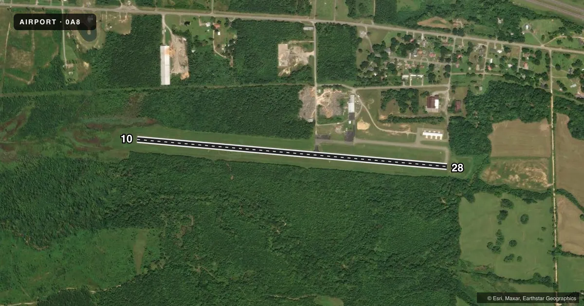
Airport sketch
Runways drawn to scale from FAA survey coordinates, rendered over satellite imagery. Not for navigation.
Approaches & charts
Services on the field
Fuel grades, oxygen, maintenance, ramp storage and lighting — as declared to the FAA by the airport operator.
Fuel & services
- Fuel
- Not available
- Oxygen (bottled)
- Not available
- Oxygen (bulk)
- Not available
- Airframe repair
- Not available
- Power plant repair
- Minor
Ramp & ground
- Transient storage
- Not published
- Landing fee
- No fee published
- Customs
- Not available
- Lighting schedule
- SEE RMK
- Beacon schedule
- SS-SR
- Beacon
- White / Green (civil land)(WG)
- Wind indicator
- Lighted
- Segmented circle
- No
Fuel & FBOs
Cheapest 100LL and Jet A on the field and nearby. Always confirm with the FBO before taxi.
Airport notes
Surface conditions, obstructions, local procedures, lighting outages and other notes published with each FAA cycle.
General notes
- PILOT ACES VIA WALK THRU GATE ON NORTH SIDE OF ARPT.
- FOR CD CTC ATLANTA ARTCC AT 770-210-7692.
Lighting notes
- ACTVT REIL RWY 10 & 28; PAPI RWY 10 & 28; MIRL RWY 10/28 - CTAF.
Other notes
- BEFORE FAA ACT.
- 1ARPT UNATNDD.
- MANAGERFOR ARPT ACES CTC 205-225-4763 OR 205-316-8574.
VFR map & nearby airports
VFR sectional. Tap any ICAO chip to open that airport.
Key facts · 0A8
Answer card- ICAO
- 0A8
- Name
- BIBB COUNTY
- Location
- CENTREVILLE, ALABAMA
- Elevation
- 250.9 ft MSL
- Traffic pattern altitude
- 1,250.9 ft MSL (1,000 AGL)
- Control tower
- Non-towered (use CTAF)
- Total runways
- 1
- Longest runway
- 10/28 · 4,206 ft
- Published ILS approaches
- 0
- Published frequencies
- 2
- Magnetic variation
- 2°
- Current flight rules
- MVFR
- Current wind
- 000° at 0 kt
- Favored runway now
- –
Bibb County Airport sits in Centreville, Alabama. The field elevation is 250.9 ft MSL. It has one runway, 10/28, which is 4,206 ft long and asphalt. The airport is unattended and there is no control tower. CTAF and UNICOM are both 122.975. No ILS approaches are published here.
Pattern altitude is not published. Use 1,000 ft AGL as the standard light-piston pattern unless the current Chart Supplement says otherwise. The runway lights are medium intensity and are controlled on the common traffic advisory frequency. Runway end identifier lights are available on both ends. Precision approach path indicators are also available for runways 10 and 28. The published remarks also say the airport was listed before FAA activation. Verify current status before you go.
There are no on-field FBOs listed in the facts. Pilot access is via the walk-through gate on the north side of the airport. For airport access, call 205-225-4763 or 205-316-8574. For clearance delivery, contact Atlanta ARTCC at 770-210-7692. If you are planning IFR or want current operational details, check the current FAA Chart Supplement before departure. The runway length is workable for light piston traffic. It is still a small unattended field, so make your plan with current weather, lighting and access details in hand.