METAR & TAF A08
A08 does not publish a METAR.
Showing the nearest reporting station: KSEM (CRAIG FLD) · 22.5 NM away. Conditions at A08 may differ.
METAR · KSEM
Observed 06:15Z
KSEM 270615Z AUTO 16003KT 9SM FEW035 SCT041 BKN048 25/25 A2995 RMK AO2
- Wind
- 160° @ 3 kt
- Visibility
- 9 SM
- Temp / Dew
- 25°C / 25°C
- Altimeter
- 29.95 inHg
- Clouds
- BKN
- Density alt
- 1,436 ft
- Ceiling
- 4,800 ft AGL
- Rules
- VFR
Airport info & contacts
Manager on record, flight service, ARTCC, attendance schedule and pattern altitude — published by the FAA and refreshed every 28 days.
Location
- From city
- 8 NM SW
- VFR sectional
- ATLANTA
- ARTCC
- ZTL · ATLANTA
- NOTAM facility
- ANB (NOTAM-D)
Airport manager
- Name
- DONALD BENNETT
- Phone
- 734-250-4119
- Address
- 5310 VAIDEN ACCESS, MARION JUNCTION AL 36759
Flight service · Hours
- FSS ANB
- ANNISTON1-800-WX-BRIEF
- Attendance
- Unattended
Frequencies
Tap any row to copy the frequency to your clipboard.
Runways & pattern
Full pagePattern entry · RWY 16
LEFT TRAFFICRunway end performance
| End | TORA | TODA | ASDA | LDA | VGSI | Approach lights | Obstruction |
|---|---|---|---|---|---|---|---|
| 16 | — | — | — | — | PAPI 2-box left(3°) | — | 10', tree, 88' from thr, 120' R of cntrln, slope 0 |
| 34 | — | — | — | — | PAPI 2-box left(3°) | — | — |
Declared distances in feet. TORA = takeoff run available, TODA = takeoff distance, ASDA = accelerate-stop, LDA = landing distance.
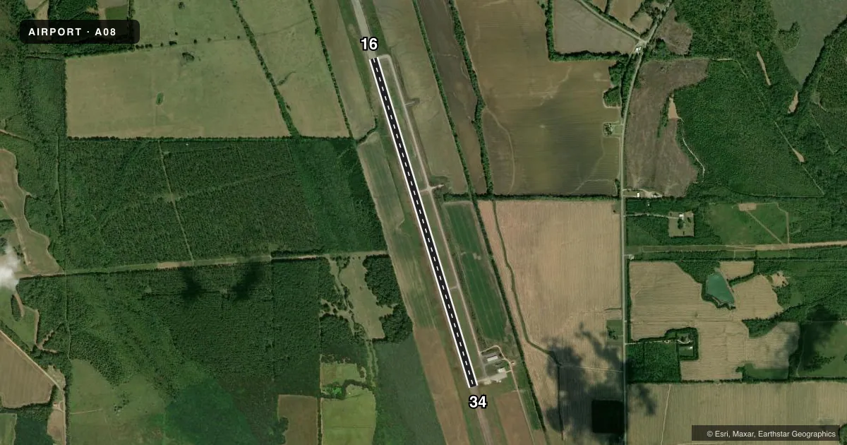
Airport sketch
Runways drawn to scale from FAA survey coordinates, rendered over satellite imagery. Not for navigation.
Approaches & charts
Services on the field
Fuel grades, oxygen, maintenance, ramp storage and lighting — as declared to the FAA by the airport operator.
Fuel & services
- Fuel
- Not available
- Oxygen (bottled)
- Not available
- Oxygen (bulk)
- Not available
- Airframe repair
- Not available
- Power plant repair
- Not available
- Other services
- AGRI,INSTR
Ramp & ground
- Transient storage
- Tie-down
- Landing fee
- No fee published
- Lighting schedule
- SEE RMK
- Beacon schedule
- SS-SR
- Beacon
- White / Green (civil land)(WG)
- Wind indicator
- No
- Segmented circle
- Yes
Fuel & FBOs
Cheapest 100LL and Jet A on the field and nearby. Always confirm with the FBO before taxi.
Airport notes
Surface conditions, obstructions, local procedures, lighting outages and other notes published with each FAA cycle.
General notes
- FOR CD CTC ATLANTA ARTCC AT 770-210-7692.
Lighting notes
- ARPT BCN CURRENTLY INOPERABLE
- ALL AIRFIELD LIGHTING CURRENTLY INOPERABLE
Runway surface & condition
- 16/34LCTD 10 FT FROM RWY EDGE.
Approach & departure obstructions
- 16SVRL CLOSE-IN OBSTN TREES LOCATED APPROX 100-120 FT L OF RWY 16 CNTRLN
- 16MARKINGS SVRLY FADED OR OBSC.
- 34MARKINGS SVRLY FADED OR OBSC.
- 16CONTROLLING OBSTN EXCEEDS A 45 DEG SLP
Other notes
- VFR ONLY.
- 16/3480 FT OVERLAY; SIDE TRSNS SMOOTH.
VFR map & nearby airports
VFR sectional. Tap any ICAO chip to open that airport.
Key facts · A08
Answer card- ICAO
- A08
- Name
- VAIDEN FLD
- Location
- MARION, ALABAMA
- Elevation
- 220 ft MSL
- Traffic pattern altitude
- 1,220 ft MSL (1,000 AGL)
- Control tower
- Non-towered (use CTAF)
- Total runways
- 1
- Longest runway
- 16/34 · 6,400 ft
- Published ILS approaches
- 0
- Published frequencies
- 1
- Magnetic variation
- 3°
- Current flight rules
- VFR
- Current wind
- 160° at 3 kt
- Favored runway now
- RWY 16
Vaiden Fld sits in Marion, Alabama at 220 ft MSL. The field has one runway, 16/34 and it is 6,400 ft long. There is no control tower. No ILS approaches are published. Pattern altitude is not published, so use the standard 1,000 ft AGL for light piston operations unless the current FAA Chart Supplement says otherwise.
Aeropro is the on-field FBO. Fuel grades are not reported in the facts. Confirm what is available with the FBO directly by phone before you go. The published remarks also matter here. Runway 16 and 34 markings are severely faded or obscured. The airport beacon is inoperable. All airfield lighting is currently inoperable. The field is published as VFR only, so plan a daylight arrival unless you have current local confirmation of usable lighting. Runway 16 has close-in trees about 100 to 120 ft left of centerline. The controlling obstruction near runway 16 exceeds a 45 degree slope. Runway 16/34 also has an 80-foot overlay with smooth side transitions.
For clearance delivery, contact Atlanta ARTCC at 770-210-7692. CTAF is 122.9. If you are planning a first visit, brief the runway markings carefully and expect a visual arrival with no instrument backup. Check the current FAA Chart Supplement for any updates before departure.