METAR & TAF 1A9
Current METAR
Observed 03:35Z
K1A9 270335Z AUTO 00000KT 10SM CLR A2995 RMK AO2
- Wind
- 000° @ 0 kt
- Visibility
- 10 SM
- Temp / Dew
- —
- Altimeter
- 29.95 inHg
- Clouds
- CLR
- Density alt
- —
- Ceiling
- Unlimited
- Rules
- VFR
Airport info & contacts
Manager on record, flight service, ARTCC, attendance schedule and pattern altitude — published by the FAA and refreshed every 28 days.
Location
- From city
- 3 NM SW
- VFR sectional
- ATLANTA
- ARTCC
- ZTL · ATLANTA
- NOTAM facility
- ANB (NOTAM-D)
Airport manager
- Name
- PAUL GARDNER
- Phone
- 334-361-0060
- Address
- 1450 AVIATION WAY, PRATTVILLE AL 36067
Flight service · Hours
- FSS ANB
- ANNISTON1-800-WX-BRIEF
- Attendance
- 0800-1700
Frequencies
Tap any row to copy the frequency to your clipboard.
Runways & pattern
Full pagePattern entry · RWY 09
LEFT TRAFFICRunway end performance
| End | TORA | TODA | ASDA | LDA | VGSI | Approach lights | Obstruction |
|---|---|---|---|---|---|---|---|
| 09 | — | — | — | — | PAPI 4-box left(4°) | — | 115', tree, 1430' from thr, 355' R of cntrln, slope 10 |
| 27 | — | — | — | — | PAPI 4-box left(3°) | — | 18', brush, 485' from thr, 157' R of cntrln, slope 15 |
Declared distances in feet. TORA = takeoff run available, TODA = takeoff distance, ASDA = accelerate-stop, LDA = landing distance.
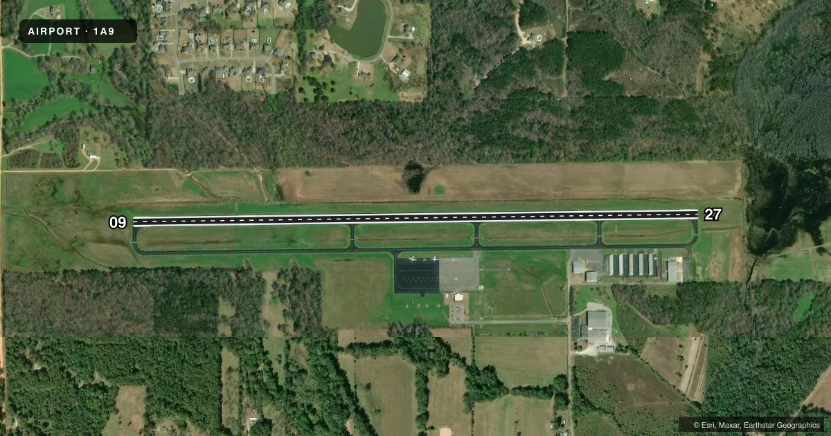
Airport sketch
Runways drawn to scale from FAA survey coordinates, rendered over satellite imagery. Not for navigation.
Approaches & charts
Services on the field
Fuel grades, oxygen, maintenance, ramp storage and lighting — as declared to the FAA by the airport operator.
Fuel & services
- Fuel
- 100LLA+
- Oxygen (bottled)
- Not available
- Oxygen (bulk)
- Not available
- Airframe repair
- Not available
- Power plant repair
- Not available
- Other services
- INSTR,RNTL
Ramp & ground
- Transient storage
- Tie-down
- Landing fee
- No fee published
- Customs
- Not available
- Lighting schedule
- SEE RMK
- Beacon schedule
- SS-SR
- Beacon
- White / Green (civil land)(WG)
- Wind indicator
- Lighted
- Segmented circle
- No
Fuel & FBOs
Cheapest 100LL and Jet A on the field and nearby. Always confirm with the FBO before taxi.
Airport notes
Surface conditions, obstructions, local procedures, lighting outages and other notes published with each FAA cycle.
General notes
- GCO AVBL ON FREQ 121.725.
- FOR CD IF UNA VIA GCO CTC ATLANTA ARTCC AT 770-210-7692.
- FBO PHONE 334-361-0060
Lighting notes
- ACTVT REIL 9 & 27; MIRL RWY 09/27- CTAF.
Fuel notes
- 100LL100LL FUEL 24 HR CREDIT CARD SVC AVBL.
- A+JET A+ FUEL 24 HR CREDIT CARD SVC AVBL
Approach & departure obstructions
- 09OTS INDEFLY.
Other notes
- MANAGERAFT HRS PHONE 334-730-3458
VFR map & nearby airports
VFR sectional. Tap any ICAO chip to open that airport.
Key facts · 1A9
Answer card- ICAO
- 1A9
- Name
- PRATTVILLE/GROUBY FLD
- Location
- PRATTVILLE, ALABAMA
- Elevation
- 224.9 ft MSL
- Traffic pattern altitude
- 1,224.9 ft MSL (1,000 AGL)
- Control tower
- Non-towered (use CTAF)
- Total runways
- 1
- Longest runway
- 09/27 · 5,400 ft
- Published ILS approaches
- 0
- Published frequencies
- 4
- Magnetic variation
- 3°
- Current flight rules
- VFR
- Current wind
- 000° at 0 kt
- Favored runway now
- –
Prattville/Grouby Fld sits in Prattville, Alabama. Field elevation is 224.9 ft MSL. The airport has one runway. Runway 09/27 is 5,400 ft long. That is the longest runway on the field. There is no control tower. CTAF and UNICOM are both 122.8. Approach and departure service is available through Montgomery on 121.2 and 269.05.
No ILS approaches are published here. Pattern altitude is not published, so use the standard 1,000 ft AGL pattern for light piston traffic unless the current Chart Supplement says otherwise. The field has active runway end identifier lights on 09 and 27. Medium intensity runway lights are on runway 09/27 and are controlled by CTAF. Published remarks also note a ground control outlet on 121.725. There is an obstruction to the sky near runway 09 that is listed as indefinite, so give the departure path a careful look before you launch.
Prattville Aviation is on the field. It carries 100LL and Jet A. The remarks say both fuels are available 24 hours with credit card service. If you need clearance delivery and ground control outlet service is not available, contact Atlanta ARTCC. For local operating details, check the current FAA Chart Supplement or call the airport operator directly.